Huixtla elevation
Huixtla (Chiapas), Mexico elevation is 52 meters and Huixtla elevation in feet is 171 ft above sea level [src 1]. Huixtla is a seat of a second-order administrative division (feature code) with elevation that is 1262 meters (4140 ft) smaller than average city elevation in Mexico.
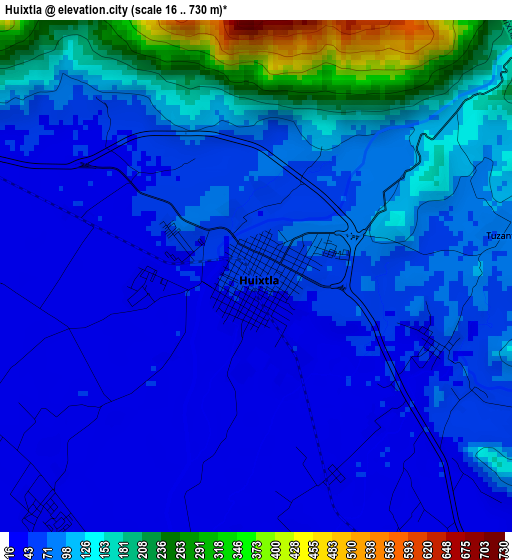
Below is the Elevation map of Huixtla, which displays elevation range with different colors. Scale of the first map is from 16 to 730 m (52 to 2395 ft) with average elevation of 93.2 meters (=306 ft) [note 1]
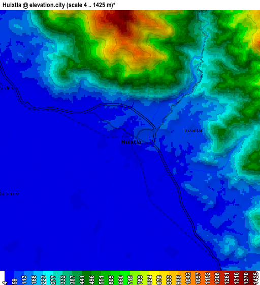
These maps also provides idea of topography and contour of this city, they are displayed at different zoom levels. More info about maps, scale and edge coordinates you can find below images.
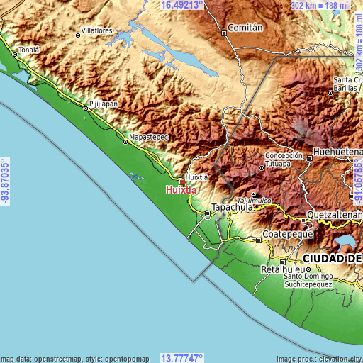
| \ | Map #1 | Map #2 | Topo.Map |
| Scale [m] | 16..730 m | 4..1425 m | × |
| Scale [ft] | 52..2395 ft | 13..4675 ft | × |
| Average | 93.2 m = 306 ft | 207.8 m = 682 ft | × |
| Width | 9.43 km = 5.9 mi | 18.87 km = 11.7 mi | 301.8 km = 187.5 mi |
| Height | 9.43 km = 5.9 mi | 18.87 km = 11.7 mi | 301.9 km = 187.6 mi |
| ↑Max Latitude | 15.181566° | 15.223973° | 16.49213° |
| Latitude at center | 15.13915° | 15.13915° | 15.13915° |
| ↓Min Latitude | 15.096726° | 15.054293° | 13.77747° |
| ← Min Longitude | -92.508045° | -92.551991° | -93.87035° |
| Longitude center | -92.4641° | -92.4641° | -92.4641° |
| →Max Longitude | -92.420155° | -92.376209° | -91.05785° |
Nearby cities:
Cities around Huixtla sort by population:
• Tuzantán elevation 79 m
4.6 km,  78°
78°
• Xochiltepec 47 m
3.5 km,  111°
111°
• Francisco I. Madero 15 m
11.5 km,  228°
228°
• Lázaro Cárdenas 28 m
10.2 km,  291°
291°
• Primer Cantón 41 m
3.3 km,  128°
128°
• Colonia Obrera 21 m
5.8 km,  218°
218°
• Chamulapita 111 m
12.8 km, 127°
• Estación Tuzantán 34 m
3.9 km,  158°
158°
• Cantón Rancho Nuevo 16 m
10.4 km, 219°
• Villa Hidalgo 116 m
10.3 km, 110°
• Cantón las Delicias 28 m
5.6 km, 223°
• Cantón Villaflor 244 m
12.3 km,  103°
103°
Multilingual:
 En español:
Huixtla elevación 52 m.
 En France:
Huixtla élévation 52 m.


Sources and notes:
- [note 1] Map square and city borders are not equal. Map elevation data is calculated only from area inside that square.
- [src 1] Elevation data from geonames database provided with same terms of usage.
- [src 2] The elevation map of Huixtla is generated using elevation data from NASA's 3 arcsec (90m) resolution SRTM data.
- [src 3] Base (background) map © OpenStreetMap contributors tiles are generated by Geofabrik and OpenTopoMap.
Copyright & License:
This Huixtla Elevation Map is licensed under CC BY-SA. You may reuse any part from this page, if you give a proper credit by linking to this URL:
 More info on terms of use page.