Ixtepec elevation
Ixtepec (Oaxaca, Ciudad Ixtepec), Mexico elevation is 68 meters and Ixtepec elevation in feet is 223 ft above sea level [src 1]. Ixtepec is a seat of a second-order administrative division (feature code) with elevation that is 1246 meters (4088 ft) smaller than average city elevation in Mexico.
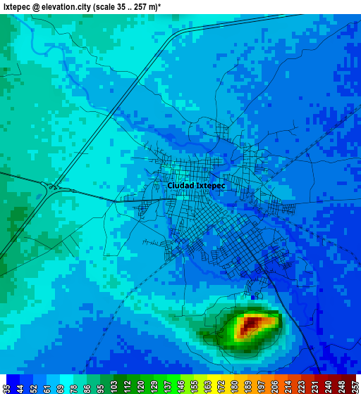
Below is the Elevation map of Ixtepec, which displays elevation range with different colors. Scale of the first map is from 35 to 257 m (115 to 843 ft) with average elevation of 66.7 meters (=219 ft) [note 1]
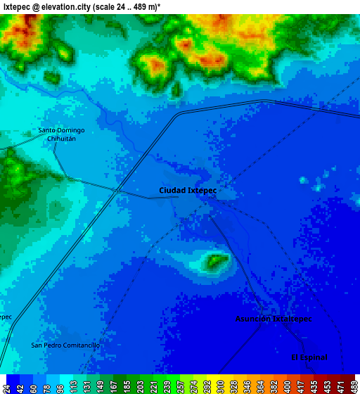
These maps also provides idea of topography and contour of this city, they are displayed at different zoom levels. More info about maps, scale and edge coordinates you can find below images.
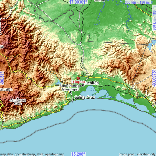
| \ | Map #1 | Map #2 | Topo.Map |
| Scale [m] | 35..257 m | 24..489 m | × |
| Scale [ft] | 115..843 ft | 79..1604 ft | × |
| Average | 66.7 m = 219 ft | 91.5 m = 300 ft | × |
| Width | 9.37 km = 5.8 mi | 18.73 km = 11.6 mi | 299.7 km = 186.2 mi |
| Height | 9.37 km = 5.8 mi | 18.73 km = 11.6 mi | 299.7 km = 186.2 mi |
| ↑Max Latitude | 16.602638° | 16.644746° | 17.90361° |
| Latitude at center | 16.56052° | 16.56052° | 16.56052° |
| ↓Min Latitude | 16.518393° | 16.476257° | 15.208° |
| ← Min Longitude | -95.147695° | -95.191641° | -96.51° |
| Longitude center | -95.10375° | -95.10375° | -95.10375° |
| →Max Longitude | -95.059805° | -95.015859° | -93.6975° |
Nearby cities:
Cities around Ixtepec sort by population:
• Juchitán de Zaragoza elevation 23 m
16.5 km,  147°
147°
• El Espinal 34 m
10.8 km,  140°
140°
• Santa María Xadani 10 m
23.9 km,  157°
157°
• Asunción Ixtaltepec 40 m
7.8 km, 144°
• La Ventosa 30 m
16.7 km,  93°
93°
• San Pedro Comitancillo 69 m
9.5 km,  216°
216°
• Santiago Laollaga 128 m
11.3 km,  283°
283°
• Santo Domingo Chihuitán 98 m
7.2 km,  298°
298°
• Colonia Jordán 34 m
21.8 km,  208°
208°
• Magdalena Tlacotepec 114 m
12.2 km,  239°
239°
• Santiago Ixtaltepec 236 m
25.4 km,  56°
56°
• Colonia San Luis 50 m
24.8 km, 216°
Multilingual:
 En español:
Ixtepec elevación 68 m.
 En France:
Ixtepec élévation 68 m.


Sources and notes:
- [note 1] Map square and city borders are not equal. Map elevation data is calculated only from area inside that square.
- [src 1] Elevation data from geonames database provided with same terms of usage.
- [src 2] The elevation map of Ixtepec is generated using elevation data from NASA's 3 arcsec (90m) resolution SRTM data.
- [src 3] Base (background) map © OpenStreetMap contributors tiles are generated by Geofabrik and OpenTopoMap.
Copyright & License:
This Ixtepec Elevation Map is licensed under CC BY-SA. You may reuse any part from this page, if you give a proper credit by linking to this URL:
 More info on terms of use page.