Xalatlaco elevation
Xalatlaco (State of Mexico), Mexico elevation is 2770 meters and Xalatlaco elevation in feet is 9088 ft above sea level [src 1]. Xalatlaco is a seat of a second-order administrative division (feature code) with elevation that is 1456 meters (4777 ft) bigger than average city elevation in Mexico.
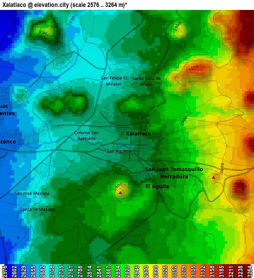
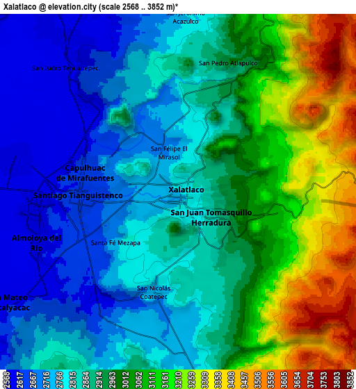
Below is the Elevation map of Xalatlaco, which displays elevation range with different colors. Scale of the first map is from 2576 to 3264 m (8451 to 10709 ft) with average elevation of 2822.8 meters (=9261 ft) [note 1]
These maps also provides idea of topography and contour of this city, they are displayed at different zoom levels. More info about maps, scale and edge coordinates you can find below images.
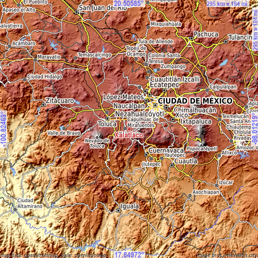
| \ | Map #1 | Map #2 | Topo.Map |
| Scale [m] | 2576..3264 m | 2568..3852 m | × |
| Scale [ft] | 8451..10709 ft | 8425..12638 ft | × |
| Average | 2822.8 m = 9261 ft | 2919.8 m = 9579 ft | × |
| Width | 9.23 km = 5.7 mi | 18.46 km = 11.5 mi | 295.3 km = 183.5 mi |
| Height | 9.23 km = 5.7 mi | 18.46 km = 11.5 mi | 295.4 km = 183.6 mi |
| ↑Max Latitude | 19.22464° | 19.266129° | 20.50585° |
| Latitude at center | 19.18314° | 19.18314° | 19.18314° |
| ↓Min Latitude | 19.14163° | 19.100109° | 17.84972° |
| ← Min Longitude | -99.462385° | -99.506331° | -100.82469° |
| Longitude center | -99.41844° | -99.41844° | -99.41844° |
| →Max Longitude | -99.374495° | -99.330549° | -98.01219° |
Nearby cities:
Cities around Xalatlaco sort by population:
• Santiago Tianguistenco de Galeana elevation 2637 m
5.1 km,  266°
266°
• Santiago Tílapa 2777 m
0.8 km,  340°
340°
• San Miguel Almaya 2726 m
3.9 km,  320°
320°
• San Felipe el Mirasol 2724 m
2.2 km,  352°
352°
• Coamilpa de Juárez 2729 m
3.1 km,  301°
301°
• Mezapa la Fábrica 2704 m
2.9 km,  253°
253°
• La Magdalena de los Reyes (La Magdalena) 2823 m
1.1 km,  50°
50°
• El Águila (La Mesa) 2818 m
2.2 km,  144°
144°
• San Juan Tomasquillo Herradura 2832 m
2 km,  128°
128°
• Techichili 2802 m
1.4 km,  196°
196°
• San José Mezapa Sección I 2673 m
4.4 km,  239°
239°
• Pueblo Nuevo 2779 m
4.8 km,  190°
190°
Multilingual:
 En español:
Xalatlaco elevación 2770 m.
 En France:
Xalatlaco élévation 2770 m.
 Auf Deutsch:
Xalatlaco höhe über dem Meeresspiegel ist 2770 m.

Sources and notes:
- [note 1] Map square and city borders are not equal. Map elevation data is calculated only from area inside that square.
- [src 1] Elevation data from geonames database provided with same terms of usage.
- [src 2] The elevation map of Xalatlaco is generated using elevation data from NASA's 3 arcsec (90m) resolution SRTM data.
- [src 3] Base (background) map © OpenStreetMap contributors tiles are generated by Geofabrik and OpenTopoMap.
Copyright & License:
This Xalatlaco Elevation Map is licensed under CC BY-SA. You may reuse any part from this page, if you give a proper credit by linking to this URL:
 More info on terms of use page.