Jaltocan elevation
Jaltocan (Hidalgo, Jaltocán), Mexico elevation is 207 meters and Jaltocan elevation in feet is 679 ft above sea level [src 1]. Jaltocan is a populated place (feature code) with elevation that is 1107 meters (3632 ft) smaller than average city elevation in Mexico.
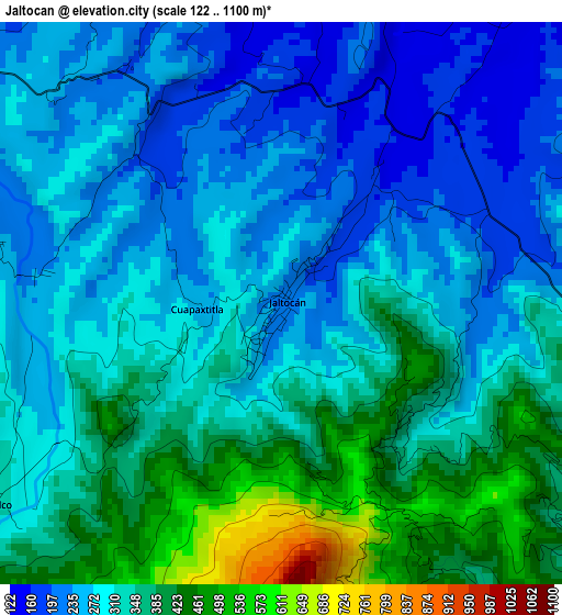
Below is the Elevation map of Jaltocan, which displays elevation range with different colors. Scale of the first map is from 122 to 1100 m (400 to 3609 ft) with average elevation of 313.2 meters (=1028 ft) [note 1]
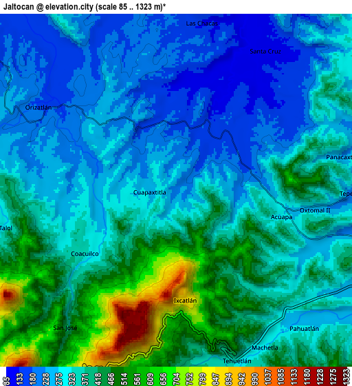
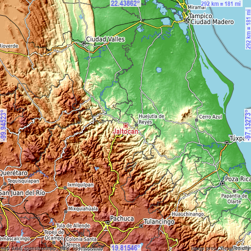
These maps also provides idea of topography and contour of this city, they are displayed at different zoom levels. More info about maps, scale and edge coordinates you can find below images.
| \ | Map #1 | Map #2 | Topo.Map |
| Scale [m] | 122..1100 m | 85..1323 m | × |
| Scale [ft] | 400..3609 ft | 279..4341 ft | × |
| Average | 313.2 m = 1028 ft | 347.1 m = 1139 ft | × |
| Width | 9.12 km = 5.7 mi | 18.23 km = 11.3 mi | 291.7 km = 181.3 mi |
| Height | 9.12 km = 5.7 mi | 18.23 km = 11.3 mi | 291.7 km = 181.3 mi |
| ↑Max Latitude | 21.173824° | 21.214797° | 22.43862° |
| Latitude at center | 21.13284° | 21.13284° | 21.13284° |
| ↓Min Latitude | 21.091844° | 21.050838° | 19.81546° |
| ← Min Longitude | -98.582925° | -98.626871° | -99.94523° |
| Longitude center | -98.53898° | -98.53898° | -98.53898° |
| →Max Longitude | -98.495035° | -98.451089° | -97.13273° |
Nearby cities:
Cities around Jaltocan sort by population:
• San Felipe Orizatlán elevation 178 m
8.3 km,  300°
300°
• Coacuilco 344 m
5.9 km,  236°
236°
• Tehuetlán 324 m
9.4 km,  160°
160°
• Pahuatlán 278 m
9.6 km,  137°
137°
• Ixcatlán 865 m
5.7 km,  175°
175°
• Santa Cruz 108 m
8.6 km,  32°
32°
• Acoapa 277 m
5.5 km,  103°
103°
• Talol 308 m
9.2 km,  261°
261°
• Tepexititla 194 m
9.5 km,  90°
90°
• Cuapaxtitla 243 m
1.4 km,  270°
270°
• San José 431 m
9.1 km,  219°
219°
• Machetla 306 m
9.4 km,  150°
150°
Multilingual:
 En español:
Jaltocan elevación 207 m.
 En France:
Jaltocan élévation 207 m.
 Auf Deutsch:
Jaltocan höhe über dem Meeresspiegel ist 207 m.

Sources and notes:
- [note 1] Map square and city borders are not equal. Map elevation data is calculated only from area inside that square.
- [src 1] Elevation data from geonames database provided with same terms of usage.
- [src 2] The elevation map of Jaltocan is generated using elevation data from NASA's 3 arcsec (90m) resolution SRTM data.
- [src 3] Base (background) map © OpenStreetMap contributors tiles are generated by Geofabrik and OpenTopoMap.
Copyright & License:
This Jaltocan Elevation Map is licensed under CC BY-SA. You may reuse any part from this page, if you give a proper credit by linking to this URL:
 More info on terms of use page.