Jojutla elevation
Jojutla (Morelos), Mexico elevation is 896 meters and Jojutla elevation in feet is 2940 ft above sea level [src 1]. Jojutla is a populated place (feature code) with elevation that is 418 meters (1371 ft) smaller than average city elevation in Mexico.
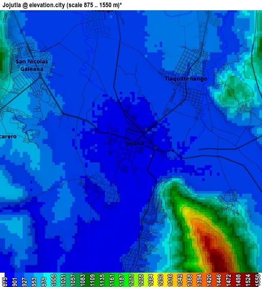
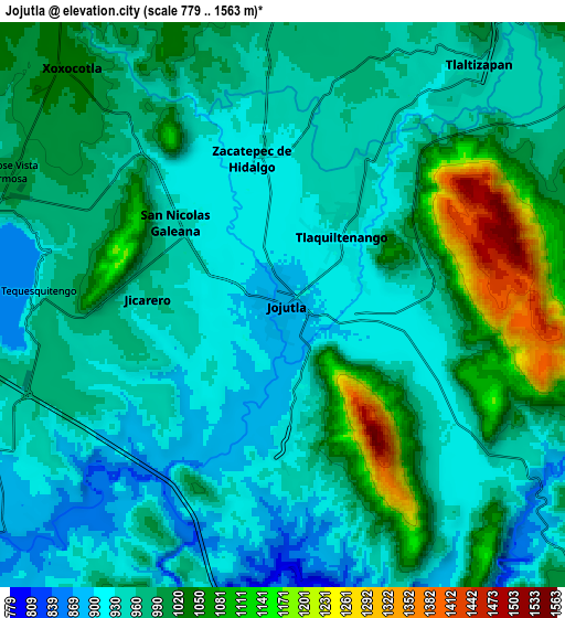
Below is the Elevation map of Jojutla, which displays elevation range with different colors. Scale of the first map is from 875 to 1550 m (2871 to 5085 ft) with average elevation of 946.5 meters (=3105 ft) [note 1]
These maps also provides idea of topography and contour of this city, they are displayed at different zoom levels. More info about maps, scale and edge coordinates you can find below images.
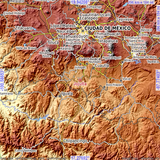
| \ | Map #1 | Map #2 | Topo.Map |
| Scale [m] | 875..1550 m | 779..1563 m | × |
| Scale [ft] | 2871..5085 ft | 2556..5128 ft | × |
| Average | 946.5 m = 3105 ft | 980.2 m = 3216 ft | × |
| Width | 9.26 km = 5.8 mi | 18.52 km = 11.5 mi | 296.3 km = 184.1 mi |
| Height | 9.26 km = 5.8 mi | 18.52 km = 11.5 mi | 296.4 km = 184.2 mi |
| ↑Max Latitude | 18.656361° | 18.697992° | 19.94208° |
| Latitude at center | 18.61472° | 18.61472° | 18.61472° |
| ↓Min Latitude | 18.573069° | 18.531407° | 17.27692° |
| ← Min Longitude | -99.224225° | -99.268171° | -100.58653° |
| Longitude center | -99.18028° | -99.18028° | -99.18028° |
| →Max Longitude | -99.136335° | -99.092389° | -97.77403° |
Nearby cities:
Cities around Jojutla sort by population:
• Zacatepec elevation 922 m
4.5 km,  347°
347°
• Tlaquiltenango 919 m
2.8 km,  39°
39°
• Galeana 938 m
4.3 km,  307°
307°
• Tlatenchi 908 m
2.1 km,  197°
197°
• Pedro Amaro 917 m
2.2 km,  159°
159°
• Higuerón 907 m
4.1 km,  180°
180°
• Unidad Habitacional José María Morelos y Pavón 961 m
4.1 km,  278°
278°
• Tequesquitengo 932 m
8.4 km,  267°
267°
• Huatecalco 947 m
7.9 km,  29°
29°
• Alfredo V. Bonfil (Chacampalco) 944 m
5.3 km, 31°
• San Antonio Chiverías 952 m
6 km, 313°
• Jicarero 959 m
4.5 km, 270°
Multilingual:
 En español:
Jojutla elevación 896 m.
 En France:
Jojutla élévation 896 m.


Sources and notes:
- [note 1] Map square and city borders are not equal. Map elevation data is calculated only from area inside that square.
- [src 1] Elevation data from geonames database provided with same terms of usage.
- [src 2] The elevation map of Jojutla is generated using elevation data from NASA's 3 arcsec (90m) resolution SRTM data.
- [src 3] Base (background) map © OpenStreetMap contributors tiles are generated by Geofabrik and OpenTopoMap.
Copyright & License:
This Jojutla Elevation Map is licensed under CC BY-SA. You may reuse any part from this page, if you give a proper credit by linking to this URL:
 More info on terms of use page.