La Concepción elevation
La Concepción (Guerrero, Acapulco de Juárez), Mexico elevation is 40 meters and La Concepción elevation in feet is 131 ft above sea level [src 1]. La Concepción is a populated place (feature code) with elevation that is 1274 meters (4180 ft) smaller than average city elevation in Mexico.
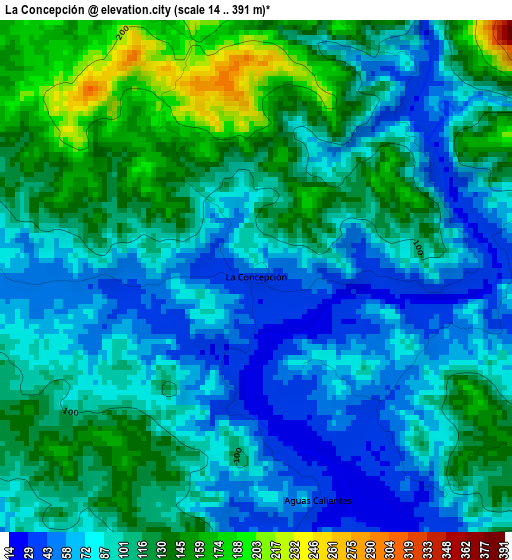
Below is the Elevation map of La Concepción, which displays elevation range with different colors. Scale of the first map is from 14 to 391 m (46 to 1283 ft) with average elevation of 100.3 meters (=329 ft) [note 1]
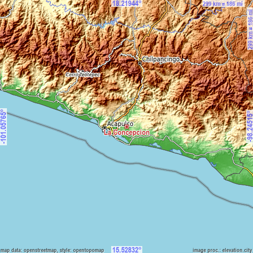
These maps also provides idea of topography and contour of this city, they are displayed at different zoom levels. More info about maps, scale and edge coordinates you can find below images.
| \ | Map #1 | Topo.Map |
| Scale [m] | 14..391 m | × |
| Scale [ft] | 46..1283 ft | × |
| Average | 100.3 m = 329 ft | × |
| Width | 9.35 km = 5.8 mi | 299.2 km = 185.9 mi |
| Height | 9.35 km = 5.8 mi | 299.2 km = 185.9 mi |
| ↑Max Latitude | 16.920718° | 18.21944° |
| Latitude at center | 16.87867° | 16.87867° |
| ↓Min Latitude | 16.836613° | 15.52832° |
| ← Min Longitude | -99.695345° | -101.05765° |
| Longitude center | -99.6514° | -99.6514° |
| →Max Longitude | -99.607455° | -98.24515° |
Nearby cities:
Cities around La Concepción sort by population:
• San Pedro las Playas elevation 10 m
10.6 km,  233°
233°
• Amatillo 42 m
6.7 km,  193°
193°
• San Isidro Gallinero (El Gallinero) 72 m
6.7 km,  272°
272°
• El Bejuco 23 m
8.4 km,  224°
224°
• Aguas Calientes 34 m
4.2 km,  163°
163°
• Cerro de Piedra 45 m
11.6 km,  168°
168°
• Apalani 181 m
7.2 km,  112°
112°
• San Pedro Cacahuatepec 65 m
7.3 km, 194°
• Campanario 177 m
9.7 km,  119°
119°
• Barrio Nuevo de los Muertos 225 m
11.5 km,  82°
82°
• El Metlapil 13 m
11.2 km,  248°
248°
• 10 de Abril 12 m
11 km,  239°
239°
Multilingual:
 En español:
La Concepción elevación 40 m.
 En France:
La Concepción élévation 40 m.
 Auf Deutsch:
La Concepción höhe über dem Meeresspiegel ist 40 m.

Sources and notes:
- [note 1] Map square and city borders are not equal. Map elevation data is calculated only from area inside that square.
- [src 1] Elevation data from geonames database provided with same terms of usage.
- [src 2] The elevation map of La Concepción is generated using elevation data from NASA's 3 arcsec (90m) resolution SRTM data.
- [src 3] Base (background) map © OpenStreetMap contributors tiles are generated by Geofabrik and OpenTopoMap.
Copyright & License:
This La Concepción Elevation Map is licensed under CC BY-SA. You may reuse any part from this page, if you give a proper credit by linking to this URL:
 More info on terms of use page.