Las Margaritas elevation
Las Margaritas (Chiapas), Mexico elevation is 1516 meters and Las Margaritas elevation in feet is 4974 ft above sea level [src 1]. Las Margaritas is a seat of a second-order administrative division (feature code) with elevation that is 202 meters (663 ft) bigger than average city elevation in Mexico.
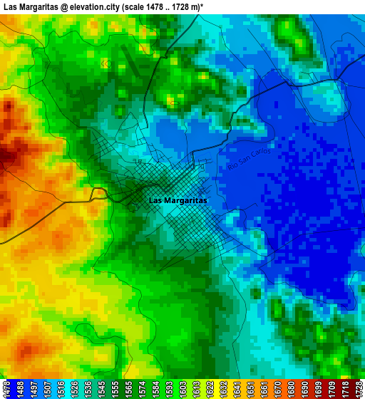
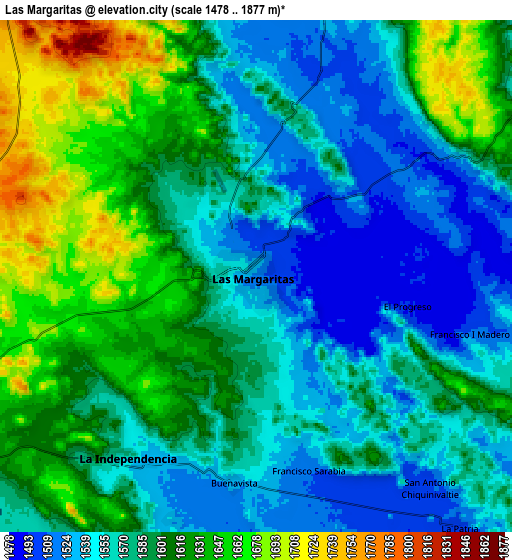
Below is the Elevation map of Las Margaritas, which displays elevation range with different colors. Scale of the first map is from 1478 to 1728 m (4849 to 5669 ft) with average elevation of 1559 meters (=5115 ft) [note 1]
These maps also provides idea of topography and contour of this city, they are displayed at different zoom levels. More info about maps, scale and edge coordinates you can find below images.
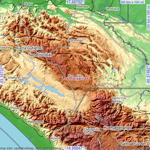
| \ | Map #1 | Map #2 | Topo.Map |
| Scale [m] | 1478..1728 m | 1478..1877 m | × |
| Scale [ft] | 4849..5669 ft | 4849..6158 ft | × |
| Average | 1559 m = 5115 ft | 1588.3 m = 5211 ft | × |
| Width | 9.38 km = 5.8 mi | 18.76 km = 11.7 mi | 300.1 km = 186.5 mi |
| Height | 9.38 km = 5.8 mi | 18.76 km = 11.7 mi | 300.1 km = 186.5 mi |
| ↑Max Latitude | 16.354822° | 16.396984° | 17.65752° |
| Latitude at center | 16.31265° | 16.31265° | 16.31265° |
| ↓Min Latitude | 16.270469° | 16.228279° | 14.95847° |
| ← Min Longitude | -92.025015° | -92.068961° | -93.38732° |
| Longitude center | -91.98107° | -91.98107° | -91.98107° |
| →Max Longitude | -91.937125° | -91.893179° | -90.57482° |
Nearby cities:
Cities around Las Margaritas sort by population:
• La Independencia elevation 1561 m
8.1 km,  214°
214°
• Villahermosa Yaluma 1728 m
10.6 km,  282°
282°
• Jalisco 1635 m
13.1 km,  2°
2°
• Yasha 1749 m
12.8 km,  313°
313°
• San José Yocnajab 1600 m
13.1 km,  239°
239°
• Francisco I. Madero 1506 m
8 km,  104°
104°
• La Patria 1501 m
11.8 km,  141°
141°
• Francisco Sarabia 1510 m
7.5 km,  164°
164°
• Buenavista 1525 m
7.8 km,  185°
185°
• Saltillo 1526 m
9.6 km,  20°
20°
• Veracruz 1559 m
10.4 km,  349°
349°
• El Progreso 1491 m
5.9 km, 100°
Multilingual:
 En español:
Las Margaritas elevación 1516 m.
 En France:
Las Margaritas élévation 1516 m.
 Auf Deutsch:
Las Margaritas höhe über dem Meeresspiegel ist 1516 m.

Sources and notes:
- [note 1] Map square and city borders are not equal. Map elevation data is calculated only from area inside that square.
- [src 1] Elevation data from geonames database provided with same terms of usage.
- [src 2] The elevation map of Las Margaritas is generated using elevation data from NASA's 3 arcsec (90m) resolution SRTM data.
- [src 3] Base (background) map © OpenStreetMap contributors tiles are generated by Geofabrik and OpenTopoMap.
Copyright & License:
This Las Margaritas Elevation Map is licensed under CC BY-SA. You may reuse any part from this page, if you give a proper credit by linking to this URL:
 More info on terms of use page.