Metepec elevation
Metepec (State of Mexico), Mexico elevation is 2623 meters and Metepec elevation in feet is 8606 ft above sea level [src 1]. Metepec is a seat of a second-order administrative division (feature code) with elevation that is 1309 meters (4295 ft) bigger than average city elevation in Mexico.
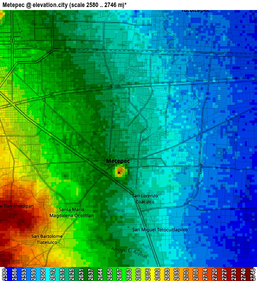
Below is the Elevation map of Metepec, which displays elevation range with different colors. Scale of the first map is from 2580 to 2746 m (8465 to 9009 ft) with average elevation of 2627.3 meters (=8620 ft) [note 1]
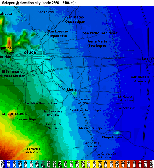
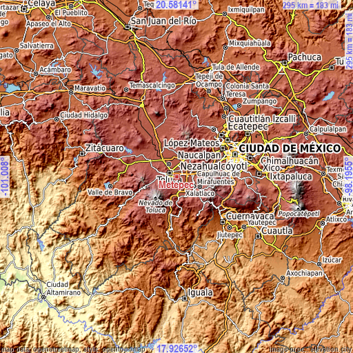
These maps also provides idea of topography and contour of this city, they are displayed at different zoom levels. More info about maps, scale and edge coordinates you can find below images.
| \ | Map #1 | Map #2 | Topo.Map |
| Scale [m] | 2580..2746 m | 2566..3106 m | × |
| Scale [ft] | 8465..9009 ft | 8419..10190 ft | × |
| Average | 2627.3 m = 8620 ft | 2649.1 m = 8691 ft | × |
| Width | 9.23 km = 5.7 mi | 18.45 km = 11.5 mi | 295.2 km = 183.4 mi |
| Height | 9.23 km = 5.7 mi | 18.45 km = 11.5 mi | 295.2 km = 183.4 mi |
| ↑Max Latitude | 19.300821° | 19.342291° | 20.58141° |
| Latitude at center | 19.25934° | 19.25934° | 19.25934° |
| ↓Min Latitude | 19.217849° | 19.176347° | 17.92652° |
| ← Min Longitude | -99.645695° | -99.689641° | -101.008° |
| Longitude center | -99.60175° | -99.60175° | -99.60175° |
| →Max Longitude | -99.557805° | -99.513859° | -98.1955° |
Nearby cities:
Cities around Metepec sort by population:
• San Salvador Tizatlalli elevation 2612 m
1.2 km,  84°
84°
• San Jerónimo Chicahualco 2606 m
2.8 km,  19°
19°
• San Francisco Cuaxusco 2640 m
2.1 km,  296°
296°
• San Jorge Pueblo Nuevo 2655 m
2.8 km,  258°
258°
• Santa María Totoltepec 2601 m
5.3 km,  10°
10°
• San Bartolomé Tlaltelulco 2688 m
4.6 km,  219°
219°
• Mexicaltzingo 2605 m
5.6 km,  161°
161°
• San Felipe Tlalmimilolpan 2726 m
4.8 km,  242°
242°
• San Miguel Totocuitlapilco 2616 m
3.5 km,  166°
166°
• Atizapán 2580 m
5.5 km,  100°
100°
• Santa María Magdalena Ocotitlán 2656 m
3.4 km, 223°
• Santa María la Asunción 2585 m
5.2 km, 80°
Multilingual:
 En español:
Municipio de Metepec elevación 2623 m.
 En France:
Metepec élévation 2623 m.
 Auf Deutsch:
Municipio Metepec höhe über dem Meeresspiegel ist 2623 m.

Sources and notes:
- [note 1] Map square and city borders are not equal. Map elevation data is calculated only from area inside that square.
- [src 1] Elevation data from geonames database provided with same terms of usage.
- [src 2] The elevation map of Metepec is generated using elevation data from NASA's 3 arcsec (90m) resolution SRTM data.
- [src 3] Base (background) map © OpenStreetMap contributors tiles are generated by Geofabrik and OpenTopoMap.
Copyright & License:
This Metepec Elevation Map is licensed under CC BY-SA. You may reuse any part from this page, if you give a proper credit by linking to this URL:
 More info on terms of use page.