Mextepec elevation
Mextepec (State of Mexico, Almoloya de Juárez), Mexico elevation is 2604 meters and Mextepec elevation in feet is 8543 ft above sea level [src 1]. Mextepec is a populated place (feature code) with elevation that is 1290 meters (4232 ft) bigger than average city elevation in Mexico.
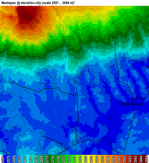
Below is the Elevation map of Mextepec, which displays elevation range with different colors. Scale of the first map is from 2551 to 3084 m (8369 to 10118 ft) with average elevation of 2667.9 meters (=8753 ft) [note 1]
These maps also provides idea of topography and contour of this city, they are displayed at different zoom levels. More info about maps, scale and edge coordinates you can find below images.
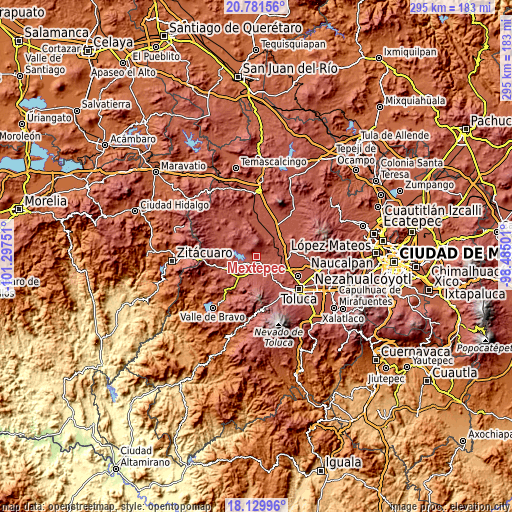
| \ | Map #1 | Topo.Map |
| Scale [m] | 2551..3084 m | × |
| Scale [ft] | 8369..10118 ft | × |
| Average | 2667.9 m = 8753 ft | × |
| Width | 9.21 km = 5.7 mi | 294.8 km = 183.2 mi |
| Height | 9.21 km = 5.7 mi | 294.9 km = 183.2 mi |
| ↑Max Latitude | 19.502609° | 20.78156° |
| Latitude at center | 19.46118° | 19.46118° |
| ↓Min Latitude | 19.41974° | 18.12996° |
| ← Min Longitude | -99.935205° | -101.29751° |
| Longitude center | -99.89126° | -99.89126° |
| →Max Longitude | -99.847315° | -98.48501° |
Nearby cities:
Cities around Mextepec sort by population:
• Salitrillo elevation 2585 m
5.3 km,  125°
125°
• San Marcos de la Loma 2721 m
8.5 km,  301°
301°
• Sitio Ejido 2595 m
1.3 km,  228°
228°
• Benito Juárez 2563 m
4.7 km,  123°
123°
• La Campanilla 2957 m
7.6 km,  315°
315°
• Santiago del Monte 2785 m
8.5 km,  218°
218°
• Laguna de Tabernillas (El Resbaloso) 2605 m
1.4 km,  89°
89°
• Colonia Doctor Gustavo Baz 2617 m
6.5 km,  209°
209°
• San Joaquín del Monte 2605 m
4.7 km,  193°
193°
• Venta de Ocotillos 2606 m
7.2 km,  279°
279°
• San Roque 2616 m
7.6 km,  286°
286°
• Ejido San Diego 2579 m
8.7 km, 127°
Multilingual:
 En español:
Mextepec elevación 2604 m.
 En France:
Mextepec élévation 2604 m.
 Auf Deutsch:
Mextepec höhe über dem Meeresspiegel ist 2604 m.

Sources and notes:
- [note 1] Map square and city borders are not equal. Map elevation data is calculated only from area inside that square.
- [src 1] Elevation data from geonames database provided with same terms of usage.
- [src 2] The elevation map of Mextepec is generated using elevation data from NASA's 3 arcsec (90m) resolution SRTM data.
- [src 3] Base (background) map © OpenStreetMap contributors tiles are generated by Geofabrik and OpenTopoMap.
Copyright & License:
This Mextepec Elevation Map is licensed under CC BY-SA. You may reuse any part from this page, if you give a proper credit by linking to this URL:
 More info on terms of use page.