Michimaloya elevation
Michimaloya (Hidalgo, Tula de Allende), Mexico elevation is 2087 meters and Michimaloya elevation in feet is 6847 ft above sea level [src 1]. Michimaloya is a populated place (feature code) with elevation that is 773 meters (2536 ft) bigger than average city elevation in Mexico.
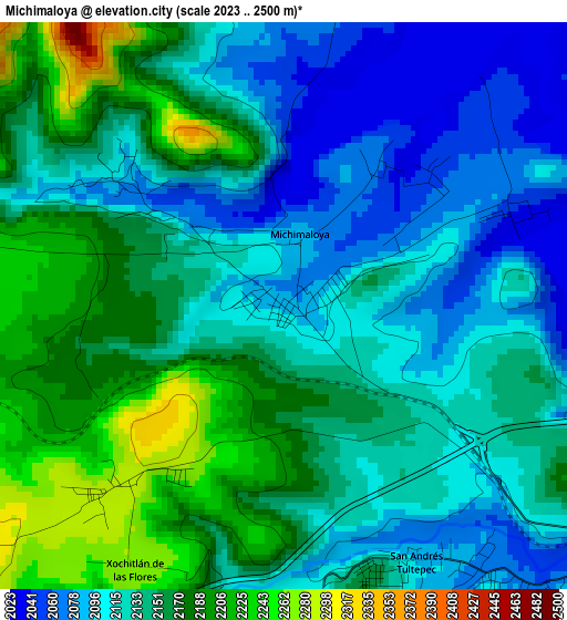
Below is the Elevation map of Michimaloya, which displays elevation range with different colors. Scale of the first map is from 2023 to 2500 m (6637 to 8202 ft) with average elevation of 2139 meters (=7018 ft) [note 1]
These maps also provides idea of topography and contour of this city, they are displayed at different zoom levels. More info about maps, scale and edge coordinates you can find below images.
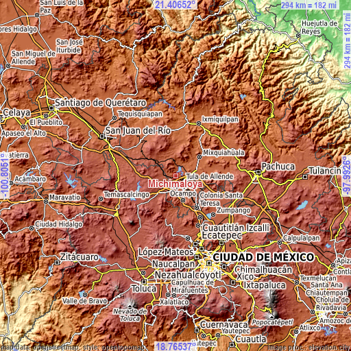
| \ | Map #1 | Topo.Map |
| Scale [m] | 2023..2500 m | × |
| Scale [ft] | 6637..8202 ft | × |
| Average | 2139 m = 7018 ft | × |
| Width | 9.18 km = 5.7 mi | 293.7 km = 182.5 mi |
| Height | 9.18 km = 5.7 mi | 293.7 km = 182.5 mi |
| ↑Max Latitude | 20.132776° | 21.40652° |
| Latitude at center | 20.09151° | 20.09151° |
| ↓Min Latitude | 20.050234° | 18.76537° |
| ← Min Longitude | -99.442795° | -100.8051° |
| Longitude center | -99.39885° | -99.39885° |
| →Max Longitude | -99.354905° | -97.9926° |
Nearby cities:
Cities around Michimaloya sort by population:
• Tula de Allende elevation 2066 m
7.2 km,  127°
127°
• El Llano 2086 m
8.8 km,  109°
109°
• San Marcos 2048 m
9.5 km,  135°
135°
• Santa Ana Ahuehuepan 2060 m
6.6 km,  58°
58°
• Santa Maria Macua 2299 m
9.4 km,  301°
301°
• Nantzha 2068 m
5.3 km, 143°
• General Pedro María Anaya 2036 m
8.9 km,  36°
36°
• San Andrés 2097 m
4.6 km,  154°
154°
• San Agustín Buenavista 2314 m
10.9 km,  240°
240°
• Residencial Arboledas 2095 m
10.6 km, 106°
• La Loma 2033 m
8.9 km,  13°
13°
• Xiteje de Zapata 2073 m
1.2 km, 58°
Multilingual:
 En español:
Michimaloya elevación 2087 m.
 En France:
Michimaloya élévation 2087 m.
 Auf Deutsch:
Michimaloya höhe über dem Meeresspiegel ist 2087 m.

Sources and notes:
- [note 1] Map square and city borders are not equal. Map elevation data is calculated only from area inside that square.
- [src 1] Elevation data from geonames database provided with same terms of usage.
- [src 2] The elevation map of Michimaloya is generated using elevation data from NASA's 3 arcsec (90m) resolution SRTM data.
- [src 3] Base (background) map © OpenStreetMap contributors tiles are generated by Geofabrik and OpenTopoMap.
Copyright & License:
This Michimaloya Elevation Map is licensed under CC BY-SA. You may reuse any part from this page, if you give a proper credit by linking to this URL:
 More info on terms of use page.