Panotla elevation
Panotla (Tlaxcala), Mexico elevation is 2230 meters and Panotla elevation in feet is 7316 ft above sea level [src 1]. Panotla is a seat of a second-order administrative division (feature code) with elevation that is 916 meters (3005 ft) bigger than average city elevation in Mexico.
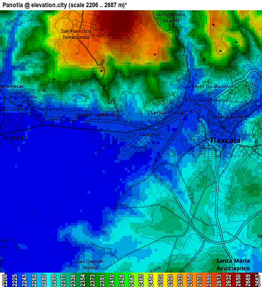
Below is the Elevation map of Panotla, which displays elevation range with different colors. Scale of the first map is from 2206 to 2687 m (7238 to 8816 ft) with average elevation of 2306 meters (=7566 ft) [note 1]
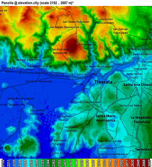
These maps also provides idea of topography and contour of this city, they are displayed at different zoom levels. More info about maps, scale and edge coordinates you can find below images.
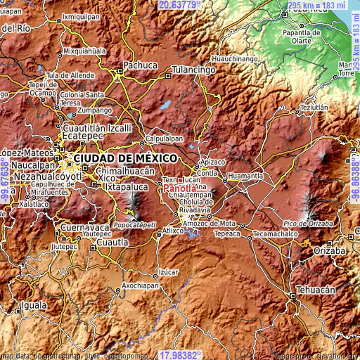
| \ | Map #1 | Map #2 | Topo.Map |
| Scale [m] | 2206..2687 m | 2192..2687 m | × |
| Scale [ft] | 7238..8816 ft | 7192..8816 ft | × |
| Average | 2306 m = 7566 ft | 2334.6 m = 7659 ft | × |
| Width | 9.22 km = 5.7 mi | 18.44 km = 11.5 mi | 295.1 km = 183.4 mi |
| Height | 9.22 km = 5.7 mi | 18.44 km = 11.5 mi | 295.1 km = 183.4 mi |
| ↑Max Latitude | 19.357656° | 19.399112° | 20.63779° |
| Latitude at center | 19.31619° | 19.31619° | 19.31619° |
| ↓Min Latitude | 19.274713° | 19.233226° | 17.98382° |
| ← Min Longitude | -98.314075° | -98.358021° | -99.67638° |
| Longitude center | -98.27013° | -98.27013° | -98.27013° |
| →Max Longitude | -98.226185° | -98.182239° | -96.86388° |
Nearby cities:
Cities around Panotla sort by population:
• Totolac elevation 2252 m
1.6 km,  49°
49°
• San Damián Texoloc 2262 m
4.5 km,  200°
200°
• San Jorge Tezoquipan 2221 m
4.5 km,  276°
276°
• San Hipólito Chimalpa 2236 m
2.1 km,  79°
79°
• Acxotla del Río 2238 m
3.5 km, 75°
• Los Reyes Quiahuixtlan 2285 m
3.2 km,  36°
36°
• San Francisco Temetzontla 2574 m
4.3 km,  332°
332°
• Zaragoza 2242 m
0.7 km,  67°
67°
• Fraccionamiento la Virgen 2240 m
0.9 km, 332°
• Santiago Tepeticpac 2248 m
5 km, 65°
• La Trinidad Chimalpa 2242 m
3 km,  60°
60°
• San Miguel Tlamahuco 2266 m
3.3 km, 74°
Multilingual:
 En español:
Panotla elevación 2230 m.
 En France:
Panotla élévation 2230 m.
 Auf Deutsch:
Panotla höhe über dem Meeresspiegel ist 2230 m.

Sources and notes:
- [note 1] Map square and city borders are not equal. Map elevation data is calculated only from area inside that square.
- [src 1] Elevation data from geonames database provided with same terms of usage.
- [src 2] The elevation map of Panotla is generated using elevation data from NASA's 3 arcsec (90m) resolution SRTM data.
- [src 3] Base (background) map © OpenStreetMap contributors tiles are generated by Geofabrik and OpenTopoMap.
Copyright & License:
This Panotla Elevation Map is licensed under CC BY-SA. You may reuse any part from this page, if you give a proper credit by linking to this URL:
 More info on terms of use page.