Piedra Labrada elevation
Piedra Labrada (Chiapas, Chicomuselo), Mexico elevation is 634 meters and Piedra Labrada elevation in feet is 2080 ft above sea level [src 1]. Piedra Labrada is a populated place (feature code) with elevation that is 680 meters (2231 ft) smaller than average city elevation in Mexico.
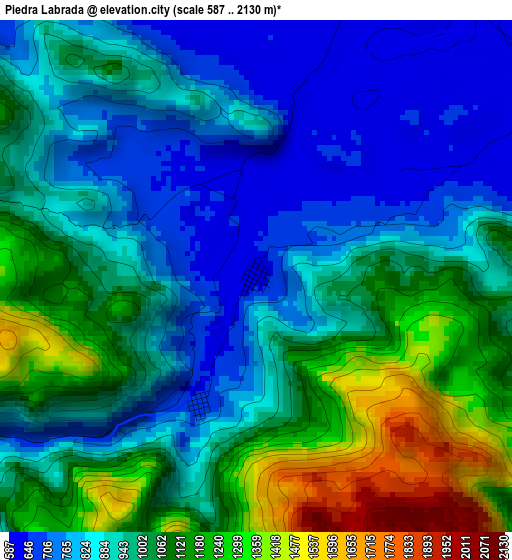
Below is the Elevation map of Piedra Labrada, which displays elevation range with different colors. Scale of the first map is from 587 to 2130 m (1926 to 6988 ft) with average elevation of 975.4 meters (=3200 ft) [note 1]
These maps also provides idea of topography and contour of this city, they are displayed at different zoom levels. More info about maps, scale and edge coordinates you can find below images.
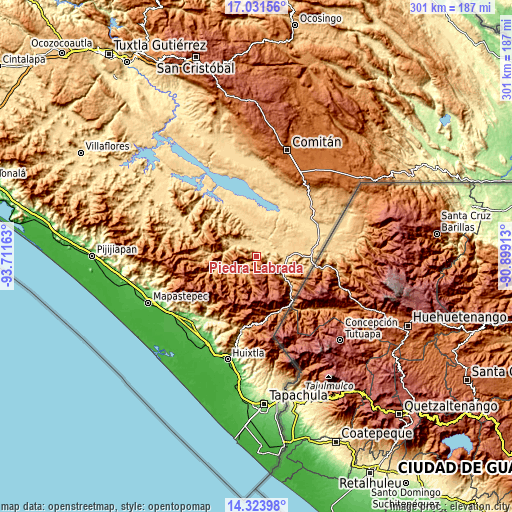
| \ | Map #1 | Topo.Map |
| Scale [m] | 587..2130 m | × |
| Scale [ft] | 1926..6988 ft | × |
| Average | 975.4 m = 3200 ft | × |
| Width | 9.41 km = 5.8 mi | 301.1 km = 187.1 mi |
| Height | 9.41 km = 5.8 mi | 301.1 km = 187.1 mi |
| ↑Max Latitude | 15.724565° | 17.03156° |
| Latitude at center | 15.68226° | 15.68226° |
| ↓Min Latitude | 15.639946° | 14.32398° |
| ← Min Longitude | -92.349325° | -93.71163° |
| Longitude center | -92.30538° | -92.30538° |
| →Max Longitude | -92.261435° | -90.89913° |
Nearby cities:
Cities around Piedra Labrada sort by population:
• Chicomuselo elevation 597 m
7.3 km,  18°
18°
• Siltepec 1566 m
14 km,  187°
187°
• Nueva Independencia 706 m
15.2 km,  42°
42°
• Bella Vista 1573 m
12.6 km,  150°
150°
• Nueva Libertad 711 m
13.9 km,  53°
53°
• Las Chicharras 650 m
10.2 km,  97°
97°
• Lázaro Cárdenas 610 m
6.7 km, 54°
• Emiliano Zapata 625 m
7.3 km, 101°
• San José las Chicharras 1510 m
11.4 km,  112°
112°
• La Rinconada 1548 m
10.7 km,  157°
157°
• Guadalupe Grijalva 634 m
15.2 km,  82°
82°
• Nuevo Pacayal 674 m
2.7 km,  203°
203°
Multilingual:
 En español:
Piedra Labrada elevación 634 m.
 En France:
Piedra Labrada élévation 634 m.
 Auf Deutsch:
Piedra Labrada höhe über dem Meeresspiegel ist 634 m.

Sources and notes:
- [note 1] Map square and city borders are not equal. Map elevation data is calculated only from area inside that square.
- [src 1] Elevation data from geonames database provided with same terms of usage.
- [src 2] The elevation map of Piedra Labrada is generated using elevation data from NASA's 3 arcsec (90m) resolution SRTM data.
- [src 3] Base (background) map © OpenStreetMap contributors tiles are generated by Geofabrik and OpenTopoMap.
Copyright & License:
This Piedra Labrada Elevation Map is licensed under CC BY-SA. You may reuse any part from this page, if you give a proper credit by linking to this URL:
 More info on terms of use page.