Pinotepa de Don Luis elevation
Pinotepa de Don Luis (Oaxaca), Mexico elevation is 424 meters and Pinotepa de Don Luis elevation in feet is 1391 ft above sea level [src 1]. Pinotepa de Don Luis is a seat of a second-order administrative division (feature code) with elevation that is 890 meters (2920 ft) smaller than average city elevation in Mexico.
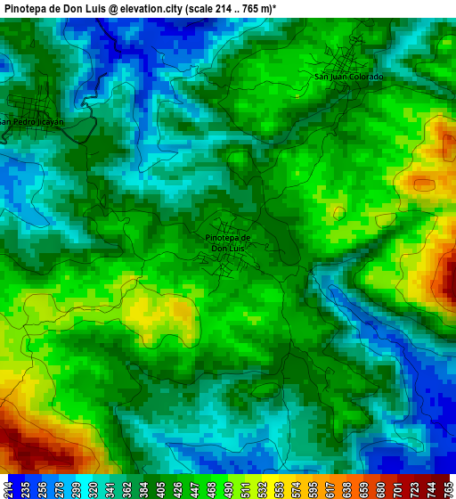
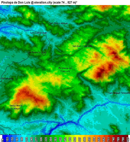
Below is the Elevation map of Pinotepa de Don Luis, which displays elevation range with different colors. Scale of the first map is from 214 to 765 m (702 to 2510 ft) with average elevation of 404.6 meters (=1327 ft) [note 1]
These maps also provides idea of topography and contour of this city, they are displayed at different zoom levels. More info about maps, scale and edge coordinates you can find below images.
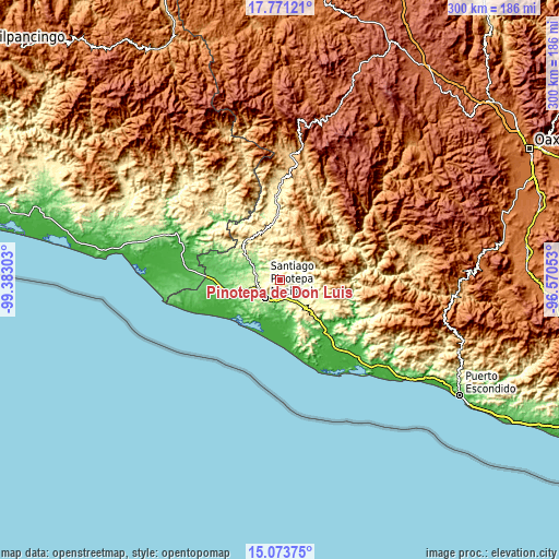
| \ | Map #1 | Map #2 | Topo.Map |
| Scale [m] | 214..765 m | 74..827 m | × |
| Scale [ft] | 702..2510 ft | 243..2713 ft | × |
| Average | 404.6 m = 1327 ft | 342 m = 1122 ft | × |
| Width | 9.37 km = 5.8 mi | 18.75 km = 11.7 mi | 299.9 km = 186.3 mi |
| Height | 9.37 km = 5.8 mi | 18.75 km = 11.7 mi | 300 km = 186.4 mi |
| ↑Max Latitude | 16.469307° | 16.511445° | 17.77121° |
| Latitude at center | 16.42716° | 16.42716° | 16.42716° |
| ↓Min Latitude | 16.385004° | 16.342839° | 15.07375° |
| ← Min Longitude | -98.020725° | -98.064671° | -99.38303° |
| Longitude center | -97.97678° | -97.97678° | -97.97678° |
| →Max Longitude | -97.932835° | -97.888889° | -96.57053° |
Nearby cities:
Cities around Pinotepa de Don Luis sort by population:
• Pinotepa Nacional elevation 211 m
12.6 km,  220°
220°
• San Juan Colorado 449 m
4.4 km,  32°
32°
• San Pedro Jicayán 404 m
4.8 km,  304°
304°
• San Andrés Huaxpaltepec 233 m
12.6 km,  149°
149°
• San Pedro Atoyac 243 m
7.1 km,  352°
352°
• San Lorenzo 240 m
11.5 km,  108°
108°
• San Miguel Tlacamama 265 m
9.3 km,  261°
261°
• San Juan Jicayán 224 m
6.6 km,  324°
324°
• Santa María Jicaltepec 517 m
8.9 km,  233°
233°
• San Miguel Tetepelcingo 230 m
8.7 km, 112°
• Santiago Jicayán 226 m
6.8 km,  328°
328°
• Rancho Viejo 232 m
9.8 km,  172°
172°
Multilingual:
 En español:
Pinotepa de Don Luis elevación 424 m.
 En France:
Pinotepa de Don Luis élévation 424 m.
 Auf Deutsch:
Pinotepa de Don Luis höhe über dem Meeresspiegel ist 424 m.
 На русском:
Pinotepa de Don Luis высота над уровнем моря 424 м
Sources and notes:
- [note 1] Map square and city borders are not equal. Map elevation data is calculated only from area inside that square.
- [src 1] Elevation data from geonames database provided with same terms of usage.
- [src 2] The elevation map of Pinotepa de Don Luis is generated using elevation data from NASA's 3 arcsec (90m) resolution SRTM data.
- [src 3] Base (background) map © OpenStreetMap contributors tiles are generated by Geofabrik and OpenTopoMap.
Copyright & License:
This Pinotepa de Don Luis Elevation Map is licensed under CC BY-SA. You may reuse any part from this page, if you give a proper credit by linking to this URL:
 More info on terms of use page.