Potrero del Llano elevation
Potrero del Llano (Veracruz, Álamo Temapache), Mexico elevation is 85 meters and Potrero del Llano elevation in feet is 279 ft above sea level [src 1]. Potrero del Llano is a populated place (feature code) with elevation that is 1229 meters (4032 ft) smaller than average city elevation in Mexico.
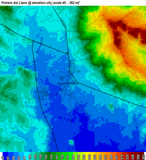
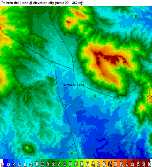
Below is the Elevation map of Potrero del Llano, which displays elevation range with different colors. Scale of the first map is from 45 to 362 m (148 to 1188 ft) with average elevation of 121.7 meters (=399 ft) [note 1]
These maps also provides idea of topography and contour of this city, they are displayed at different zoom levels. More info about maps, scale and edge coordinates you can find below images.
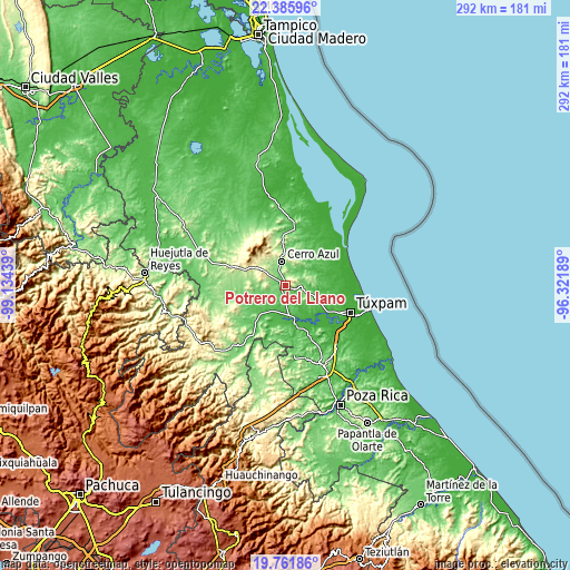
| \ | Map #1 | Map #2 | Topo.Map |
| Scale [m] | 45..362 m | 29..362 m | × |
| Scale [ft] | 148..1188 ft | 95..1188 ft | × |
| Average | 121.7 m = 399 ft | 120.8 m = 396 ft | × |
| Width | 9.12 km = 5.7 mi | 18.24 km = 11.3 mi | 291.8 km = 181.3 mi |
| Height | 9.12 km = 5.7 mi | 18.24 km = 11.3 mi | 291.8 km = 181.3 mi |
| ↑Max Latitude | 21.120699° | 21.161686° | 22.38596° |
| Latitude at center | 21.0797° | 21.0797° | 21.0797° |
| ↓Min Latitude | 21.03869° | 20.997668° | 19.76186° |
| ← Min Longitude | -97.772085° | -97.816031° | -99.13439° |
| Longitude center | -97.72814° | -97.72814° | -97.72814° |
| →Max Longitude | -97.684195° | -97.640249° | -96.32189° |
Nearby cities:
Cities around Potrero del Llano sort by population:
• Álamo elevation 23 m
19.5 km,  163°
163°
• Cerro Azul 141 m
12.6 km,  353°
353°
• Tepetzintla 279 m
15.9 km,  306°
306°
• Chapopote Núñez 30 m
17.1 km, 164°
• La Camelia 50 m
20.9 km,  192°
192°
• Temapache 233 m
9.1 km,  99°
99°
• Tierra Blanca 301 m
21.8 km,  294°
294°
• Tierra Blanca Booxter 79 m
9.5 km,  172°
172°
• La Unión 28 m
21.8 km, 162°
• Vegas de la Soledad y Soledad Dos 51 m
18.5 km,  215°
215°
• Zacamixtle 142 m
18.7 km,  2°
2°
• El Anono 178 m
20.9 km,  20°
20°
Multilingual:
 En español:
Potrero del Llano elevación 85 m.
 En France:
Potrero del Llano élévation 85 m.
 Auf Deutsch:
Potrero del Llano höhe über dem Meeresspiegel ist 85 m.

Sources and notes:
- [note 1] Map square and city borders are not equal. Map elevation data is calculated only from area inside that square.
- [src 1] Elevation data from geonames database provided with same terms of usage.
- [src 2] The elevation map of Potrero del Llano is generated using elevation data from NASA's 3 arcsec (90m) resolution SRTM data.
- [src 3] Base (background) map © OpenStreetMap contributors tiles are generated by Geofabrik and OpenTopoMap.
Copyright & License:
This Potrero del Llano Elevation Map is licensed under CC BY-SA. You may reuse any part from this page, if you give a proper credit by linking to this URL:
 More info on terms of use page.