Reforma elevation
Reforma (Chiapas), Mexico elevation is 27 meters and Reforma elevation in feet is 89 ft above sea level [src 1]. Reforma is a seat of a second-order administrative division (feature code) with elevation that is 1287 meters (4222 ft) smaller than average city elevation in Mexico.
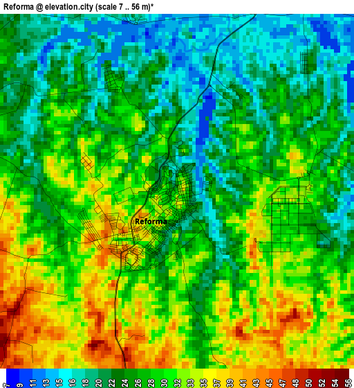
Below is the Elevation map of Reforma, which displays elevation range with different colors. Scale of the first map is from 7 to 56 m (23 to 184 ft) with average elevation of 27.4 meters (=90 ft) [note 1]
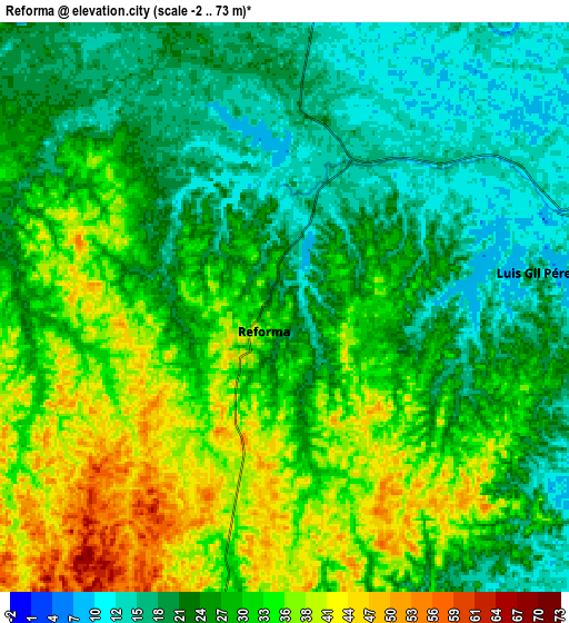
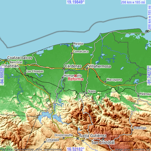
These maps also provides idea of topography and contour of this city, they are displayed at different zoom levels. More info about maps, scale and edge coordinates you can find below images.
| \ | Map #1 | Map #2 | Topo.Map |
| Scale [m] | 7..56 m | -2..73 m | × |
| Scale [ft] | 23..184 ft | -7..240 ft | × |
| Average | 27.4 m = 90 ft | 27.5 m = 90 ft | × |
| Width | 9.3 km = 5.8 mi | 18.6 km = 11.6 mi | 297.6 km = 184.9 mi |
| Height | 9.3 km = 5.8 mi | 18.6 km = 11.6 mi | 297.6 km = 184.9 mi |
| ↑Max Latitude | 17.907011° | 17.948823° | 19.19849° |
| Latitude at center | 17.86519° | 17.86519° | 17.86519° |
| ↓Min Latitude | 17.823359° | 17.781518° | 16.52182° |
| ← Min Longitude | -93.192915° | -93.236861° | -94.55522° |
| Longitude center | -93.14897° | -93.14897° | -93.14897° |
| →Max Longitude | -93.105025° | -93.061079° | -91.74272° |
Nearby cities:
Cities around Reforma sort by population:
• Río Viejo Primera Sección elevation 12 m
19.7 km,  65°
65°
• Luis Gil Pérez 20 m
8.3 km,  82°
82°
• Anacleto Canabal 2da. Sección 12 m
18 km,  47°
47°
• Cucuyulapa Primera Sección 21 m
18 km,  320°
320°
• Gregorio Méndez 14 m
21.3 km,  18°
18°
• El Carmen (El Limón) 28 m
3.3 km,  328°
328°
• Huacapa y Amestoy 15 m
21.6 km,  346°
346°
• Cumuapa 1ra. Sección 17 m
13.4 km,  4°
4°
• Pablo L. Sidar 9 m
13.3 km, 72°
• Nuevo Volcán Chichonal 43 m
11.1 km,  157°
157°
• Rafael Pascacio Gamboa 29 m
13.9 km,  295°
295°
• Miguel Hidalgo 17 m
5.7 km,  36°
36°
Multilingual:
 En español:
Reforma elevación 27 m.
 En France:
Reforma élévation 27 m.


Sources and notes:
- [note 1] Map square and city borders are not equal. Map elevation data is calculated only from area inside that square.
- [src 1] Elevation data from geonames database provided with same terms of usage.
- [src 2] The elevation map of Reforma is generated using elevation data from NASA's 3 arcsec (90m) resolution SRTM data.
- [src 3] Base (background) map © OpenStreetMap contributors tiles are generated by Geofabrik and OpenTopoMap.
Copyright & License:
This Reforma Elevation Map is licensed under CC BY-SA. You may reuse any part from this page, if you give a proper credit by linking to this URL:
 More info on terms of use page.