San Andrés Hueyacatitla elevation
San Andrés Hueyacatitla (Puebla, San Salvador el Verde), Mexico elevation is 2511 meters and San Andrés Hueyacatitla elevation in feet is 8238 ft above sea level [src 1]. San Andrés Hueyacatitla is a populated place (feature code) with elevation that is 1197 meters (3927 ft) bigger than average city elevation in Mexico.
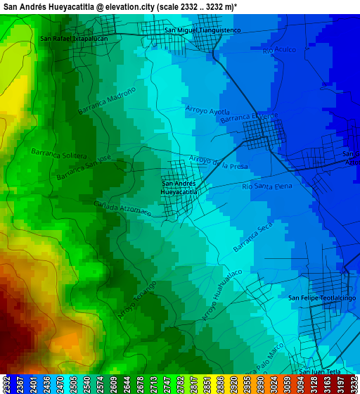
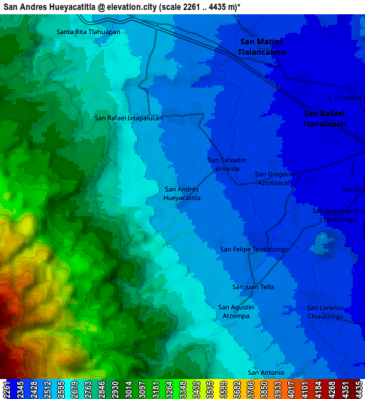
Below is the Elevation map of San Andrés Hueyacatitla, which displays elevation range with different colors. Scale of the first map is from 2332 to 3232 m (7651 to 10604 ft) with average elevation of 2570.6 meters (=8434 ft) [note 1]
These maps also provides idea of topography and contour of this city, they are displayed at different zoom levels. More info about maps, scale and edge coordinates you can find below images.
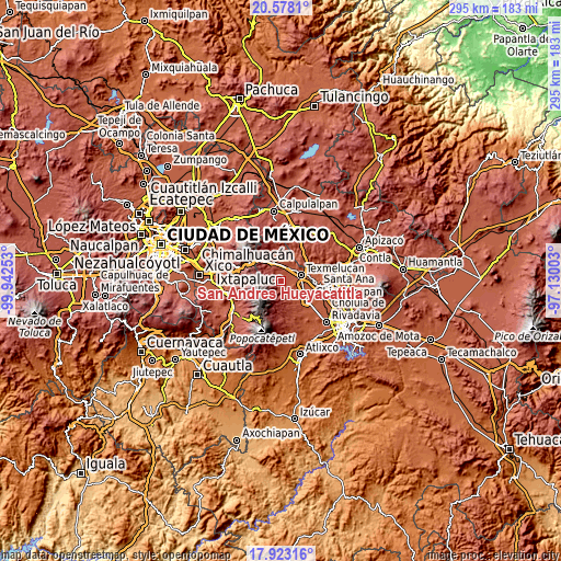
| \ | Map #1 | Map #2 | Topo.Map |
| Scale [m] | 2332..3232 m | 2261..4435 m | × |
| Scale [ft] | 7651..10604 ft | 7418..14551 ft | × |
| Average | 2570.6 m = 8434 ft | 2698.8 m = 8854 ft | × |
| Width | 9.23 km = 5.7 mi | 18.45 km = 11.5 mi | 295.2 km = 183.4 mi |
| Height | 9.23 km = 5.7 mi | 18.45 km = 11.5 mi | 295.2 km = 183.4 mi |
| ↑Max Latitude | 19.297482° | 19.338953° | 20.5781° |
| Latitude at center | 19.256° | 19.256° | 19.256° |
| ↓Min Latitude | 19.214508° | 19.173005° | 17.92316° |
| ← Min Longitude | -98.580225° | -98.624171° | -99.94253° |
| Longitude center | -98.53628° | -98.53628° | -98.53628° |
| →Max Longitude | -98.492335° | -98.448389° | -97.13003° |
Nearby cities:
Cities around San Andrés Hueyacatitla sort by population:
• Teotlaltzingo elevation 2430 m
4.7 km,  126°
126°
• San Rafael Ixtapalucan 2581 m
4.6 km,  329°
329°
• Santa María Texmelucan 2484 m
4.2 km,  357°
357°
• San Simón Atzitzintla 2329 m
6.4 km,  82°
82°
• San Juan Tetla 2490 m
5.6 km,  143°
143°
• San Miguel Tianguistenco 2459 m
4.3 km,  7°
7°
• San Salvador el Verde 2411 m
2.6 km,  53°
53°
• San Gregorio Aztotoacan 2359 m
4.7 km, 78°
• Analco de Ponciano Arriaga (Santa Cruz Analco) 2376 m
3.9 km, 76°
• San Matías Atzala 2348 m
5.8 km,  95°
95°
• Tlacotepec de José Manzo 2340 m
5.7 km,  71°
71°
• San Agustín Atzompa 2574 m
6.5 km,  158°
158°
Multilingual:
 En español:
San Andrés Hueyacatitla elevación 2511 m.
 En France:
San Andrés Hueyacatitla élévation 2511 m.
 Auf Deutsch:
San Andrés Hueyacatitla höhe über dem Meeresspiegel ist 2511 m.
 На русском:
San Andrés Hueyacatitla высота над уровнем моря 2511 м
Sources and notes:
- [note 1] Map square and city borders are not equal. Map elevation data is calculated only from area inside that square.
- [src 1] Elevation data from geonames database provided with same terms of usage.
- [src 2] The elevation map of San Andrés Hueyacatitla is generated using elevation data from NASA's 3 arcsec (90m) resolution SRTM data.
- [src 3] Base (background) map © OpenStreetMap contributors tiles are generated by Geofabrik and OpenTopoMap.
Copyright & License:
This San Andrés Hueyacatitla Elevation Map is licensed under CC BY-SA. You may reuse any part from this page, if you give a proper credit by linking to this URL:
 More info on terms of use page.