San Andrés Timilpan elevation
San Andrés Timilpan (State of Mexico, Timilpan), Mexico elevation is 2671 meters and San Andrés Timilpan elevation in feet is 8763 ft above sea level [src 1]. San Andrés Timilpan is a seat of a second-order administrative division (feature code) with elevation that is 1357 meters (4452 ft) bigger than average city elevation in Mexico.
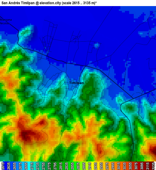
Below is the Elevation map of San Andrés Timilpan, which displays elevation range with different colors. Scale of the first map is from 2615 to 3135 m (8579 to 10285 ft) with average elevation of 2746.3 meters (=9010 ft) [note 1]
These maps also provides idea of topography and contour of this city, they are displayed at different zoom levels. More info about maps, scale and edge coordinates you can find below images.
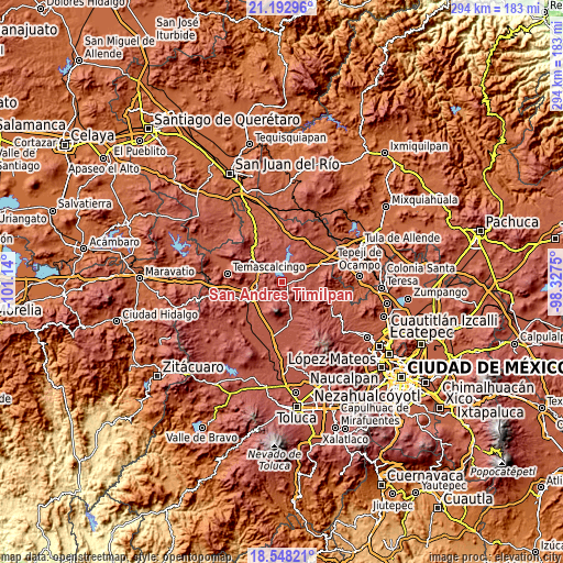
| \ | Map #1 | Topo.Map |
| Scale [m] | 2615..3135 m | × |
| Scale [ft] | 8579..10285 ft | × |
| Average | 2746.3 m = 9010 ft | × |
| Width | 9.19 km = 5.7 mi | 294.1 km = 182.7 mi |
| Height | 9.19 km = 5.7 mi | 294.1 km = 182.7 mi |
| ↑Max Latitude | 19.917422° | 21.19296° |
| Latitude at center | 19.8761° | 19.8761° |
| ↓Min Latitude | 19.834767° | 18.54821° |
| ← Min Longitude | -99.777695° | -101.14° |
| Longitude center | -99.73375° | -99.73375° |
| →Max Longitude | -99.689805° | -98.3275° |
Nearby cities:
Cities around San Andrés Timilpan sort by population:
• Santiago Acutzilapan elevation 2757 m
10.5 km,  198°
198°
• San Juan Tuxtepec 2734 m
10.7 km,  100°
100°
• Xhimojay 2662 m
10.8 km,  62°
62°
• San Marcos Tlazalpan 2731 m
8 km,  167°
167°
• San Felipe Pueblo Nuevo 2944 m
12.3 km,  192°
192°
• San Bartolo Morelos 2715 m
12.1 km,  145°
145°
• Tercera Manzana de Zaragoza 2633 m
2.9 km,  317°
317°
• El Palmito 2639 m
7.1 km,  50°
50°
• Boshindó 2574 m
12.2 km,  293°
293°
• Pathé 2542 m
12.4 km,  297°
297°
• San Juanico Sector Uno 2636 m
7.4 km,  331°
331°
• La Estancia Sector Uno (La Estancia) 2737 m
6.1 km,  264°
264°
Multilingual:
 En español:
San Andrés Timilpan elevación 2671 m.
 En France:
San Andrés Timilpan élévation 2671 m.
 Auf Deutsch:
San Andrés Timilpan höhe über dem Meeresspiegel ist 2671 m.
 На русском:
San Andrés Timilpan высота над уровнем моря 2671 м
Sources and notes:
- [note 1] Map square and city borders are not equal. Map elevation data is calculated only from area inside that square.
- [src 1] Elevation data from geonames database provided with same terms of usage.
- [src 2] The elevation map of San Andrés Timilpan is generated using elevation data from NASA's 3 arcsec (90m) resolution SRTM data.
- [src 3] Base (background) map © OpenStreetMap contributors tiles are generated by Geofabrik and OpenTopoMap.
Copyright & License:
This San Andrés Timilpan Elevation Map is licensed under CC BY-SA. You may reuse any part from this page, if you give a proper credit by linking to this URL:
 More info on terms of use page.