San Cristóbal Amatlán elevation
San Cristóbal Amatlán (Oaxaca), Mexico elevation is 1733 meters and San Cristóbal Amatlán elevation in feet is 5686 ft above sea level [src 1]. San Cristóbal Amatlán is a seat of a second-order administrative division (feature code) with elevation that is 419 meters (1375 ft) bigger than average city elevation in Mexico.
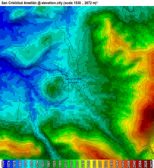
Below is the Elevation map of San Cristóbal Amatlán, which displays elevation range with different colors. Scale of the first map is from 1530 to 2672 m (5020 to 8766 ft) with average elevation of 1907.2 meters (=6257 ft) [note 1]
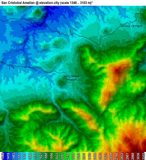
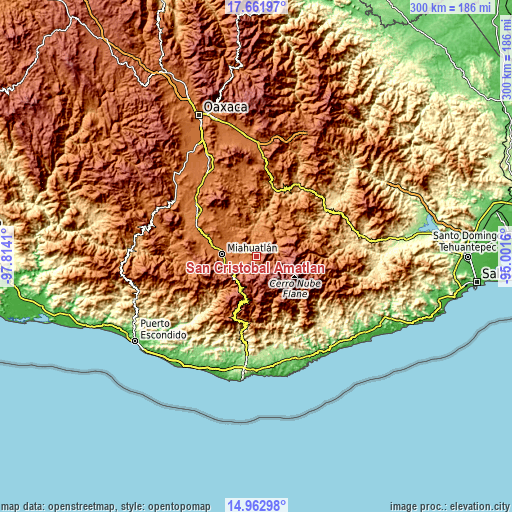
These maps also provides idea of topography and contour of this city, they are displayed at different zoom levels. More info about maps, scale and edge coordinates you can find below images.
| \ | Map #1 | Map #2 | Topo.Map |
| Scale [m] | 1530..2672 m | 1348..3103 m | × |
| Scale [ft] | 5020..8766 ft | 4423..10180 ft | × |
| Average | 1907.2 m = 6257 ft | 1913.5 m = 6278 ft | × |
| Width | 9.38 km = 5.8 mi | 18.76 km = 11.7 mi | 300.1 km = 186.5 mi |
| Height | 9.38 km = 5.8 mi | 18.76 km = 11.7 mi | 300.1 km = 186.5 mi |
| ↑Max Latitude | 16.359301° | 16.401462° | 17.66197° |
| Latitude at center | 16.31713° | 16.31713° | 16.31713° |
| ↓Min Latitude | 16.27495° | 16.232761° | 14.96298° |
| ← Min Longitude | -96.451795° | -96.495741° | -97.8141° |
| Longitude center | -96.40785° | -96.40785° | -96.40785° |
| →Max Longitude | -96.363905° | -96.319959° | -95.0016° |
Nearby cities:
Cities around San Cristóbal Amatlán sort by population:
• San Pedro Mixtepec elevation 2132 m
14.2 km,  111°
111°
• Santa Catarina Roatina 1774 m
12.5 km,  250°
250°
• Santo Tomás Tamazulapam 1713 m
19.3 km, 254°
• San José Lachiguirí 1694 m
10.2 km,  48°
48°
• San Andrés Paxtlán 2010 m
15.5 km,  223°
223°
• San Francisco Logueche 1845 m
5.2 km,  38°
38°
• San Sebastián Río Hondo 2543 m
16 km,  202°
202°
• San Ildefonso Amatlán 1546 m
9.1 km,  281°
281°
• San Luis Amatlán 1503 m
12.4 km,  308°
308°
• Sitio de Xitlapehua 1554 m
13.8 km,  286°
286°
• Santa Catalina Quieri 1965 m
15.1 km,  88°
88°
• San Juan Mixtepec 2051 m
12.3 km, 111°
Multilingual:
 En español:
San Cristóbal Amatlán elevación 1733 m.
 En France:
San Cristóbal Amatlán élévation 1733 m.
 Auf Deutsch:
San Cristóbal Amatlán höhe über dem Meeresspiegel ist 1733 m.
 На русском:
San Cristóbal Amatlán высота над уровнем моря 1733 м
Sources and notes:
- [note 1] Map square and city borders are not equal. Map elevation data is calculated only from area inside that square.
- [src 1] Elevation data from geonames database provided with same terms of usage.
- [src 2] The elevation map of San Cristóbal Amatlán is generated using elevation data from NASA's 3 arcsec (90m) resolution SRTM data.
- [src 3] Base (background) map © OpenStreetMap contributors tiles are generated by Geofabrik and OpenTopoMap.
Copyright & License:
This San Cristóbal Amatlán Elevation Map is licensed under CC BY-SA. You may reuse any part from this page, if you give a proper credit by linking to this URL:
 More info on terms of use page.