San Juan Atepec elevation
San Juan Atepec (Oaxaca), Mexico elevation is 2028 meters and San Juan Atepec elevation in feet is 6654 ft above sea level [src 1]. San Juan Atepec is a populated place (feature code) with elevation that is 714 meters (2343 ft) bigger than average city elevation in Mexico.
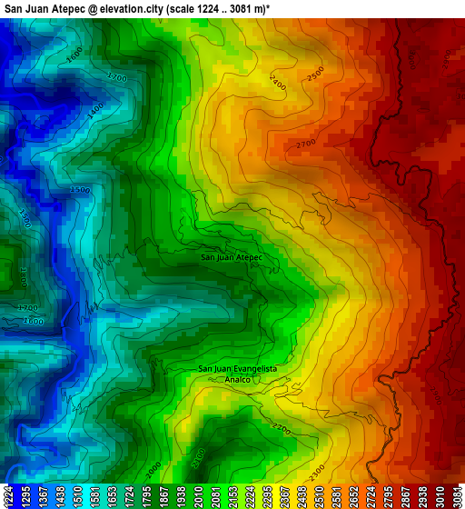
Below is the Elevation map of San Juan Atepec, which displays elevation range with different colors. Scale of the first map is from 1224 to 3081 m (4016 to 10108 ft) with average elevation of 2160.2 meters (=7087 ft) [note 1]
These maps also provides idea of topography and contour of this city, they are displayed at different zoom levels. More info about maps, scale and edge coordinates you can find below images.
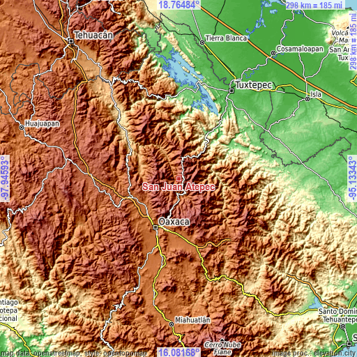
| \ | Map #1 | Topo.Map |
| Scale [m] | 1224..3081 m | × |
| Scale [ft] | 4016..10108 ft | × |
| Average | 2160.2 m = 7087 ft | × |
| Width | 9.32 km = 5.8 mi | 298.3 km = 185.4 mi |
| Height | 9.32 km = 5.8 mi | 298.4 km = 185.4 mi |
| ↑Max Latitude | 17.470113° | 18.76484° |
| Latitude at center | 17.42819° | 17.42819° |
| ↓Min Latitude | 17.386257° | 16.08168° |
| ← Min Longitude | -96.583625° | -97.94593° |
| Longitude center | -96.53968° | -96.53968° |
| →Max Longitude | -96.495735° | -95.13343° |
Nearby cities:
Cities around San Juan Atepec sort by population:
• Ixtlán de Juárez elevation 2034 m
12 km,  152°
152°
• San Miguel Aloápam 2330 m
16.2 km,  263°
263°
• San Juan Quiotepec 1978 m
19.9 km,  345°
345°
• Tanetze de Zaragoza 1371 m
26 km,  102°
102°
• Teococuilco de Marcos Pérez 1796 m
11.6 km,  223°
223°
• San Miguel Abejones 2257 m
7.4 km,  277°
277°
• San Juan Yaee 1454 m
27.2 km,  89°
89°
• San Pedro Yólox 1920 m
17.9 km,  355°
355°
• Santiago Comaltepec 2038 m
15.3 km, 356°
• San Juan Juquila Vijanos 1530 m
26.4 km,  108°
108°
• Santa María Yavesía 2016 m
24.4 km, 151°
• San Pablo Macuiltianguis 2120 m
11.8 km, 353°
Multilingual:
 En español:
San Juan Atepec elevación 2028 m.
 En France:
San Juan Atepec élévation 2028 m.
 Auf Deutsch:
San Juan Atepec höhe über dem Meeresspiegel ist 2028 m.

Sources and notes:
- [note 1] Map square and city borders are not equal. Map elevation data is calculated only from area inside that square.
- [src 1] Elevation data from geonames database provided with same terms of usage.
- [src 2] The elevation map of San Juan Atepec is generated using elevation data from NASA's 3 arcsec (90m) resolution SRTM data.
- [src 3] Base (background) map © OpenStreetMap contributors tiles are generated by Geofabrik and OpenTopoMap.
Copyright & License:
This San Juan Atepec Elevation Map is licensed under CC BY-SA. You may reuse any part from this page, if you give a proper credit by linking to this URL:
 More info on terms of use page.