San Juan Mazatlán elevation
San Juan Mazatlán (Oaxaca), Mexico elevation is 534 meters and San Juan Mazatlán elevation in feet is 1752 ft above sea level [src 1]. San Juan Mazatlán is a populated place (feature code) with elevation that is 780 meters (2559 ft) smaller than average city elevation in Mexico.
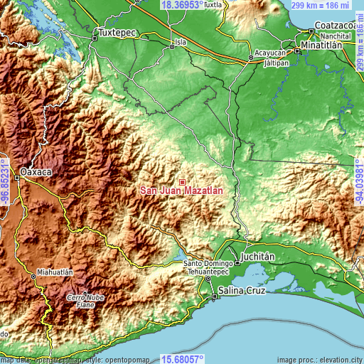
Below is the Elevation map of San Juan Mazatlán, which displays elevation range with different colors. Scale of the first map is from 259 to 834 m (850 to 2736 ft) with average elevation of 481.4 meters (=1579 ft) [note 1]
These maps also provides idea of topography and contour of this city, they are displayed at different zoom levels. More info about maps, scale and edge coordinates you can find below images.

| \ | Map #1 | Topo.Map |
| Scale [m] | 259..834 m | × |
| Scale [ft] | 850..2736 ft | × |
| Average | 481.4 m = 1579 ft | × |
| Width | 9.34 km = 5.8 mi | 299 km = 185.8 mi |
| Height | 9.34 km = 5.8 mi | 299 km = 185.8 mi |
| ↑Max Latitude | 17.071894° | 18.36953° |
| Latitude at center | 17.02988° | 17.02988° |
| ↓Min Latitude | 16.987857° | 15.68057° |
| ← Min Longitude | -95.490005° | -96.85231° |
| Longitude center | -95.44606° | -95.44606° |
| →Max Longitude | -95.402115° | -94.03981° |
Nearby cities:
Cities around San Juan Mazatlán sort by population:
• San Miguel Quetzaltepec elevation 1203 m
34 km,  259°
259°
• San Lucas Camotlán 1290 m
30 km,  251°
251°
• Santa María Guenagati 330 m
33.8 km,  163°
163°
• Santiago Quiavicuzas 1393 m
34.2 km,  237°
237°
• Santa María Puxmetacán 396 m
32.5 km,  324°
324°
• Santiago Ixcuintepec 869 m
21.5 km, 240°
• Constitución Mexicana 72 m
35.4 km,  12°
12°
• Santiago Malacatepec 987 m
17.2 km,  265°
265°
• Zacatal 550 m
27.7 km,  111°
111°
• Encinal Colorado 280 m
36.1 km,  93°
93°
• San José de las Flores 57 m
36 km, 8°
• Santa Margarita Huitepec 1368 m
25.9 km, 246°
Multilingual:
 En español:
Mazatlán elevación 534 m.
 En France:
San Juan Mazatlán élévation 534 m.
 Auf Deutsch:
San Juan Mazatlán höhe über dem Meeresspiegel ist 534 m.

Sources and notes:
- [note 1] Map square and city borders are not equal. Map elevation data is calculated only from area inside that square.
- [src 1] Elevation data from geonames database provided with same terms of usage.
- [src 2] The elevation map of San Juan Mazatlán is generated using elevation data from NASA's 3 arcsec (90m) resolution SRTM data.
- [src 3] Base (background) map © OpenStreetMap contributors tiles are generated by Geofabrik and OpenTopoMap.
Copyright & License:
This San Juan Mazatlán Elevation Map is licensed under CC BY-SA. You may reuse any part from this page, if you give a proper credit by linking to this URL:
 More info on terms of use page.