San Juan Xiutetelco elevation
San Juan Xiutetelco (Puebla, Xiutetelco), Mexico elevation is 1941 meters and San Juan Xiutetelco elevation in feet is 6368 ft above sea level [src 1]. San Juan Xiutetelco is a seat of a second-order administrative division (feature code) with elevation that is 627 meters (2057 ft) bigger than average city elevation in Mexico.
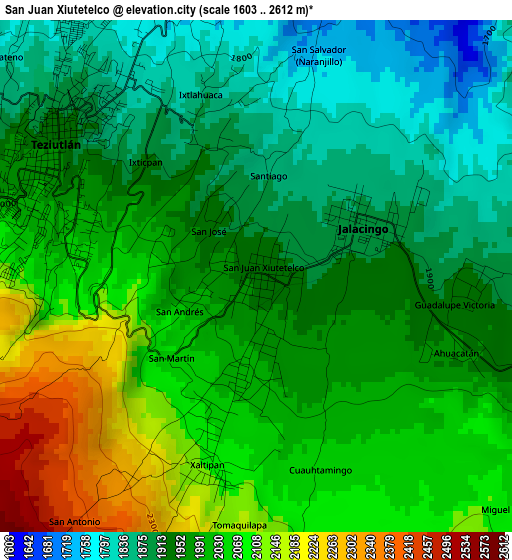
Below is the Elevation map of San Juan Xiutetelco, which displays elevation range with different colors. Scale of the first map is from 1603 to 2612 m (5259 to 8570 ft) with average elevation of 1985.5 meters (=6514 ft) [note 1]
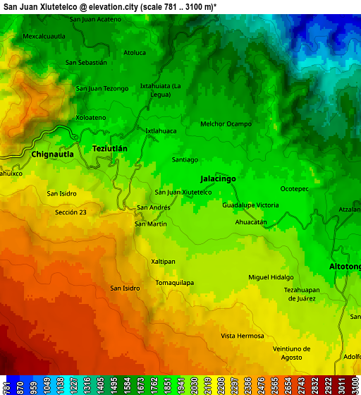
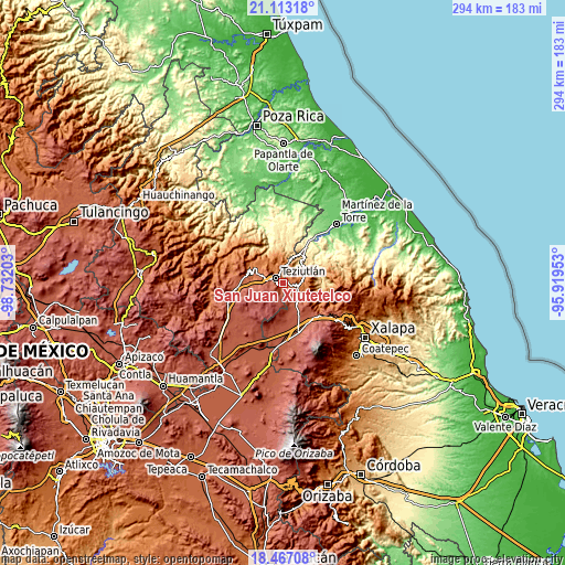
These maps also provides idea of topography and contour of this city, they are displayed at different zoom levels. More info about maps, scale and edge coordinates you can find below images.
| \ | Map #1 | Map #2 | Topo.Map |
| Scale [m] | 1603..2612 m | 781..3100 m | × |
| Scale [ft] | 5259..8570 ft | 2562..10171 ft | × |
| Average | 1985.5 m = 6514 ft | 2004.2 m = 6575 ft | × |
| Width | 9.19 km = 5.7 mi | 18.39 km = 11.4 mi | 294.2 km = 182.8 mi |
| Height | 9.2 km = 5.7 mi | 18.39 km = 11.4 mi | 294.2 km = 182.8 mi |
| ↑Max Latitude | 19.836973° | 19.878305° | 21.11318° |
| Latitude at center | 19.79563° | 19.79563° | 19.79563° |
| ↓Min Latitude | 19.754276° | 19.712912° | 18.46708° |
| ← Min Longitude | -97.369725° | -97.413671° | -98.73203° |
| Longitude center | -97.32578° | -97.32578° | -97.32578° |
| →Max Longitude | -97.281835° | -97.237889° | -95.91953° |
Nearby cities:
Cities around San Juan Xiutetelco sort by population:
• Jalacingo elevation 1889 m
2 km,  64°
64°
• San Francisco 2013 m
2.1 km,  186°
186°
• San Salvador (Naranjillo) 1749 m
4.1 km,  15°
15°
• San Andrés 2033 m
1.5 km,  245°
245°
• San José 1935 m
1.2 km,  314°
314°
• Ahuacatán 1958 m
3.2 km,  114°
114°
• San Martín 2050 m
2.1 km,  226°
226°
• Ixticpan 1917 m
2.8 km,  316°
316°
• Santiago 1869 m
1.8 km,  7°
7°
• Cuaxoxpan 1971 m
2.5 km,  303°
303°
• Cuauhtamingo 2047 m
3.6 km,  160°
160°
• Ixtlahuaca 1881 m
3.2 km,  342°
342°
Multilingual:
 En español:
San Juan Xiutetelco elevación 1941 m.
 En France:
San Juan Xiutetelco élévation 1941 m.
 Auf Deutsch:
San Juan Xiutetelco höhe über dem Meeresspiegel ist 1941 m.
 На русском:
San Juan Xiutetelco высота над уровнем моря 1941 м
Sources and notes:
- [note 1] Map square and city borders are not equal. Map elevation data is calculated only from area inside that square.
- [src 1] Elevation data from geonames database provided with same terms of usage.
- [src 2] The elevation map of San Juan Xiutetelco is generated using elevation data from NASA's 3 arcsec (90m) resolution SRTM data.
- [src 3] Base (background) map © OpenStreetMap contributors tiles are generated by Geofabrik and OpenTopoMap.
Copyright & License:
This San Juan Xiutetelco Elevation Map is licensed under CC BY-SA. You may reuse any part from this page, if you give a proper credit by linking to this URL:
 More info on terms of use page.