San Miguel Tenochtitlán elevation
San Miguel Tenochtitlán (State of Mexico, Jocotitlán), Mexico elevation is 2586 meters and San Miguel Tenochtitlán elevation in feet is 8484 ft above sea level [src 1]. San Miguel Tenochtitlán is a populated place (feature code) with elevation that is 1272 meters (4173 ft) bigger than average city elevation in Mexico.
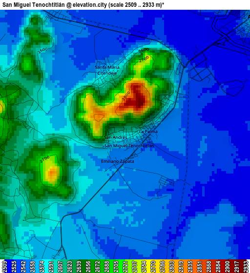
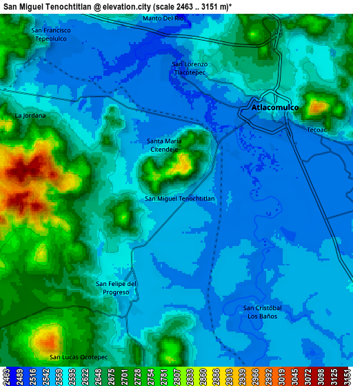
Below is the Elevation map of San Miguel Tenochtitlán, which displays elevation range with different colors. Scale of the first map is from 2509 to 2933 m (8232 to 9623 ft) with average elevation of 2575.7 meters (=8450 ft) [note 1]
These maps also provides idea of topography and contour of this city, they are displayed at different zoom levels. More info about maps, scale and edge coordinates you can find below images.
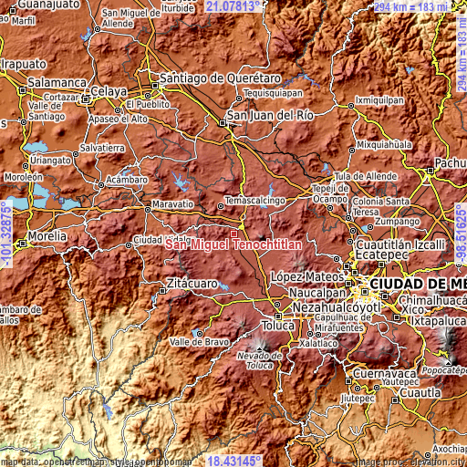
| \ | Map #1 | Map #2 | Topo.Map |
| Scale [m] | 2509..2933 m | 2463..3151 m | × |
| Scale [ft] | 8232..9623 ft | 8081..10338 ft | × |
| Average | 2575.7 m = 8450 ft | 2609.4 m = 8561 ft | × |
| Width | 9.2 km = 5.7 mi | 18.39 km = 11.4 mi | 294.3 km = 182.9 mi |
| Height | 9.2 km = 5.7 mi | 18.39 km = 11.4 mi | 294.3 km = 182.9 mi |
| ↑Max Latitude | 19.801632° | 19.842974° | 21.07813° |
| Latitude at center | 19.76028° | 19.76028° | 19.76028° |
| ↓Min Latitude | 19.718917° | 19.677543° | 18.43145° |
| ← Min Longitude | -99.966445° | -100.010391° | -101.32875° |
| Longitude center | -99.9225° | -99.9225° | -99.9225° |
| →Max Longitude | -99.878555° | -99.834609° | -98.51625° |
Nearby cities:
Cities around San Miguel Tenochtitlán sort by population:
• San Lorenzo Tlacotepec elevation 2544 m
5.9 km,  10°
10°
• Santa María Citendejé 2575 m
2.5 km,  345°
345°
• Santiago Citendejé 2572 m
2.4 km,  343°
343°
• San Juan Coajomulco 2651 m
4.9 km,  260°
260°
• Santiago Casandeje 2768 m
5 km,  282°
282°
• San Felipe del Progreso 2579 m
6 km,  211°
211°
• Santa Cruz Bombatevi 2572 m
6.2 km,  37°
37°
• Colonia Río Lerma (Tic Ti) 2546 m
5.7 km,  27°
27°
• Ejido del Tunal Nenaxi 2545 m
2.3 km,  141°
141°
• Cuendo 2547 m
5.2 km,  329°
329°
• El Obraje 2611 m
5.9 km,  225°
225°
• Concepción Caro 2608 m
1.9 km,  48°
48°
Multilingual:
 En español:
San Miguel Tenochtitlán elevación 2586 m.
 En France:
San Miguel Tenochtitlán élévation 2586 m.
 Auf Deutsch:
San Miguel Tenochtitlán höhe über dem Meeresspiegel ist 2586 m.
 На русском:
San Miguel Tenochtitlán высота над уровнем моря 2586 м
Sources and notes:
- [note 1] Map square and city borders are not equal. Map elevation data is calculated only from area inside that square.
- [src 1] Elevation data from geonames database provided with same terms of usage.
- [src 2] The elevation map of San Miguel Tenochtitlán is generated using elevation data from NASA's 3 arcsec (90m) resolution SRTM data.
- [src 3] Base (background) map © OpenStreetMap contributors tiles are generated by Geofabrik and OpenTopoMap.
Copyright & License:
This San Miguel Tenochtitlán Elevation Map is licensed under CC BY-SA. You may reuse any part from this page, if you give a proper credit by linking to this URL:
 More info on terms of use page.