San Miguel Chimalapa elevation
San Miguel Chimalapa (Oaxaca), Mexico elevation is 128 meters and San Miguel Chimalapa elevation in feet is 420 ft above sea level [src 1]. San Miguel Chimalapa is a populated place (feature code) with elevation that is 1186 meters (3891 ft) smaller than average city elevation in Mexico.
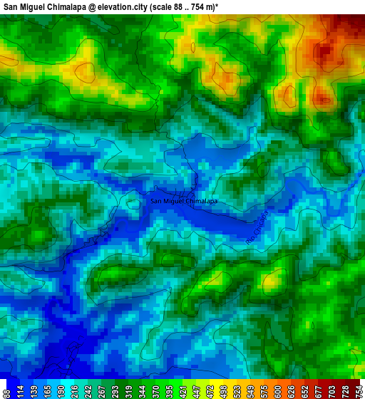
Below is the Elevation map of San Miguel Chimalapa, which displays elevation range with different colors. Scale of the first map is from 88 to 754 m (289 to 2474 ft) with average elevation of 280.6 meters (=921 ft) [note 1]
These maps also provides idea of topography and contour of this city, they are displayed at different zoom levels. More info about maps, scale and edge coordinates you can find below images.
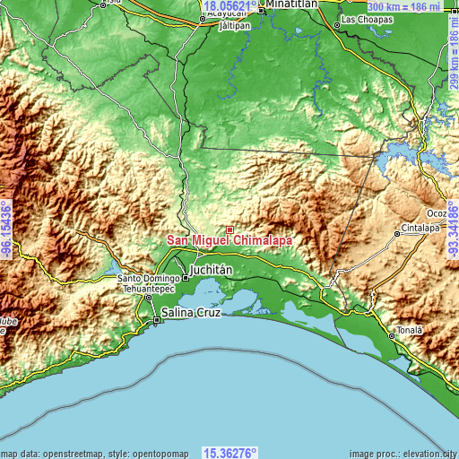
| \ | Map #1 | Topo.Map |
| Scale [m] | 88..754 m | × |
| Scale [ft] | 289..2474 ft | × |
| Average | 280.6 m = 921 ft | × |
| Width | 9.36 km = 5.8 mi | 299.5 km = 186.1 mi |
| Height | 9.36 km = 5.8 mi | 299.5 km = 186.1 mi |
| ↑Max Latitude | 16.756324° | 18.05621° |
| Latitude at center | 16.71424° | 16.71424° |
| ↓Min Latitude | 16.672147° | 15.36276° |
| ← Min Longitude | -94.792055° | -96.15436° |
| Longitude center | -94.74811° | -94.74811° |
| →Max Longitude | -94.704165° | -93.34186° |
Nearby cities:
Cities around San Miguel Chimalapa sort by population:
• Matías Romero elevation 208 m
36 km,  300°
300°
• Unión Hidalgo 15 m
28.3 km,  197°
197°
• La Ventosa 30 m
27.9 km,  229°
229°
• Niltepec 69 m
22 km,  139°
139°
• Chicapa de Castro 11 m
31.7 km,  194°
194°
• Colonia Progreso 257 m
36.6 km,  285°
285°
• Santa María Chimalapa 313 m
22.5 km,  17°
17°
• La Venta 32 m
17.6 km, 204°
• El Bajío 209 m
36.2 km, 302°
• Lázaro Cárdenas 232 m
12 km,  277°
277°
• La Blanca 62 m
14.5 km,  155°
155°
• Santiago Ixtaltepec 236 m
17 km,  260°
260°
Multilingual:
 En español:
San Miguel Chimalapa elevación 128 m.
 En France:
San Miguel Chimalapa élévation 128 m.
 Auf Deutsch:
San Miguel Chimalapa höhe über dem Meeresspiegel ist 128 m.
 На русском:
San Miguel Chimalapa высота над уровнем моря 128 м
Sources and notes:
- [note 1] Map square and city borders are not equal. Map elevation data is calculated only from area inside that square.
- [src 1] Elevation data from geonames database provided with same terms of usage.
- [src 2] The elevation map of San Miguel Chimalapa is generated using elevation data from NASA's 3 arcsec (90m) resolution SRTM data.
- [src 3] Base (background) map © OpenStreetMap contributors tiles are generated by Geofabrik and OpenTopoMap.
Copyright & License:
This San Miguel Chimalapa Elevation Map is licensed under CC BY-SA. You may reuse any part from this page, if you give a proper credit by linking to this URL:
 More info on terms of use page.