San Pablo Huitzo elevation
San Pablo Huitzo (Oaxaca), Mexico elevation is 1691 meters and San Pablo Huitzo elevation in feet is 5548 ft above sea level [src 1]. San Pablo Huitzo is a seat of a second-order administrative division (feature code) with elevation that is 377 meters (1237 ft) bigger than average city elevation in Mexico.
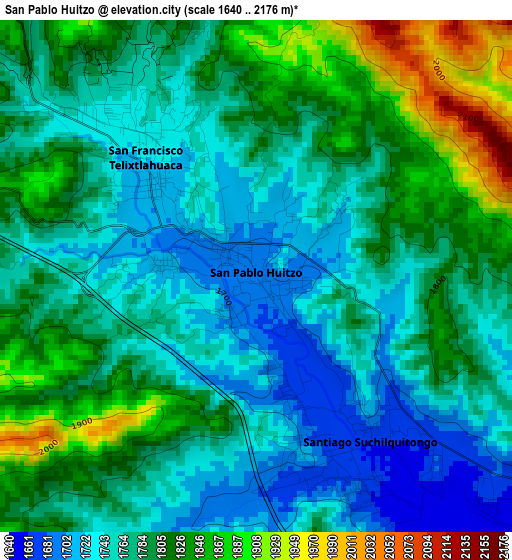
Below is the Elevation map of San Pablo Huitzo, which displays elevation range with different colors. Scale of the first map is from 1640 to 2176 m (5381 to 7139 ft) with average elevation of 1783.4 meters (=5851 ft) [note 1]
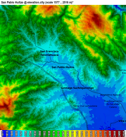
These maps also provides idea of topography and contour of this city, they are displayed at different zoom levels. More info about maps, scale and edge coordinates you can find below images.
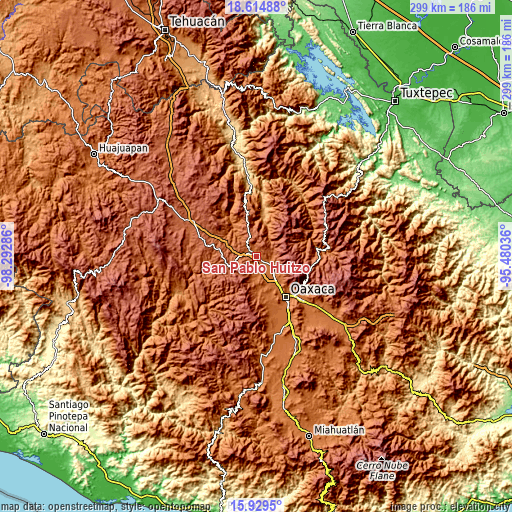
| \ | Map #1 | Map #2 | Topo.Map |
| Scale [m] | 1640..2176 m | 1577..2516 m | × |
| Scale [ft] | 5381..7139 ft | 5174..8255 ft | × |
| Average | 1783.4 m = 5851 ft | 1873.3 m = 6146 ft | × |
| Width | 9.33 km = 5.8 mi | 18.66 km = 11.6 mi | 298.6 km = 185.5 mi |
| Height | 9.33 km = 5.8 mi | 18.66 km = 11.6 mi | 298.6 km = 185.5 mi |
| ↑Max Latitude | 17.319038° | 17.360986° | 18.61488° |
| Latitude at center | 17.27708° | 17.27708° | 17.27708° |
| ↓Min Latitude | 17.235113° | 17.193136° | 15.9295° |
| ← Min Longitude | -96.930555° | -96.974501° | -98.29286° |
| Longitude center | -96.88661° | -96.88661° | -96.88661° |
| →Max Longitude | -96.842665° | -96.798719° | -95.48036° |
Nearby cities:
Cities around San Pablo Huitzo sort by population:
• San Francisco Telixtlahuaca elevation 1723 m
3 km,  317°
317°
• Villa de Etla 1666 m
12.2 km,  130°
130°
• Santiago Suchilquitongo 1675 m
2.8 km,  161°
161°
• Magdalena Apasco 1666 m
8.1 km,  119°
119°
• San Juan del Estado 1745 m
9.3 km,  91°
91°
• Fraccionamiento Ex-Hacienda Catano 1651 m
9.3 km, 126°
• Santo Tomás Mazaltepec 1674 m
11.7 km,  173°
173°
• Reyes Etla 1623 m
11.1 km,  138°
138°
• Fraccionamiento San Miguel 1714 m
12.8 km, 124°
• San Andrés Zautla 1651 m
10.3 km, 166°
• Santa Cruz Lachixolana 1656 m
6.4 km,  148°
148°
• Santiago Tenango 2053 m
13.6 km,  292°
292°
Multilingual:
 En español:
San Pablo Huitzo elevación 1691 m.
 En France:
San Pablo Huitzo élévation 1691 m.
 Auf Deutsch:
San Pablo Huitzo höhe über dem Meeresspiegel ist 1691 m.

Sources and notes:
- [note 1] Map square and city borders are not equal. Map elevation data is calculated only from area inside that square.
- [src 1] Elevation data from geonames database provided with same terms of usage.
- [src 2] The elevation map of San Pablo Huitzo is generated using elevation data from NASA's 3 arcsec (90m) resolution SRTM data.
- [src 3] Base (background) map © OpenStreetMap contributors tiles are generated by Geofabrik and OpenTopoMap.
Copyright & License:
This San Pablo Huitzo Elevation Map is licensed under CC BY-SA. You may reuse any part from this page, if you give a proper credit by linking to this URL:
 More info on terms of use page.