San Pedro Pochutla elevation
San Pedro Pochutla (Oaxaca), Mexico elevation is 156 meters and San Pedro Pochutla elevation in feet is 512 ft above sea level [src 1]. San Pedro Pochutla is a seat of a second-order administrative division (feature code) with elevation that is 1158 meters (3799 ft) smaller than average city elevation in Mexico.
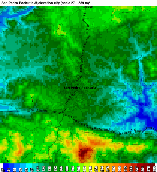
Below is the Elevation map of San Pedro Pochutla, which displays elevation range with different colors. Scale of the first map is from 27 to 389 m (89 to 1276 ft) with average elevation of 155.3 meters (=510 ft) [note 1]
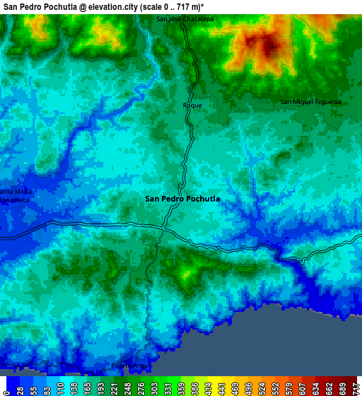
These maps also provides idea of topography and contour of this city, they are displayed at different zoom levels. More info about maps, scale and edge coordinates you can find below images.
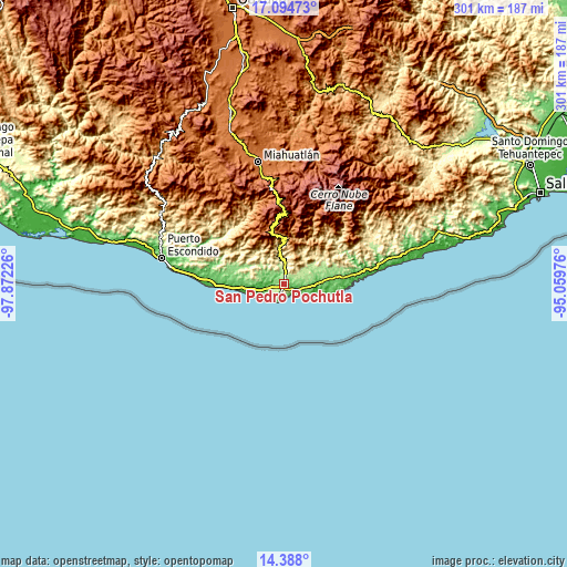
| \ | Map #1 | Map #2 | Topo.Map |
| Scale [m] | 27..389 m | 0..717 m | × |
| Scale [ft] | 89..1276 ft | 0..2352 ft | × |
| Average | 155.3 m = 510 ft | 166.1 m = 545 ft | × |
| Width | 9.41 km = 5.8 mi | 18.81 km = 11.7 mi | 301 km = 187 mi |
| Height | 9.41 km = 5.8 mi | 18.81 km = 11.7 mi | 301 km = 187 mi |
| ↑Max Latitude | 15.788162° | 15.830445° | 17.09473° |
| Latitude at center | 15.74587° | 15.74587° | 15.74587° |
| ↓Min Latitude | 15.703569° | 15.66126° | 14.388° |
| ← Min Longitude | -96.509955° | -96.553901° | -97.87226° |
| Longitude center | -96.46601° | -96.46601° | -96.46601° |
| →Max Longitude | -96.422065° | -96.378119° | -95.05976° |
Nearby cities:
Cities around San Pedro Pochutla sort by population:
• Santa María Huatulco elevation 230 m
18.3 km,  58°
58°
• Puerto Ángel 20 m
9 km,  197°
197°
• Candelaria Loxicha 452 m
20.3 km,  351°
351°
• San José Chacalapa 231 m
9.3 km,  1°
1°
• Santa María Tonameca 40 m
8.7 km,  271°
271°
• San Roque 199 m
4.6 km, 3°
• Cuapinolito (Azulillo) 214 m
17.9 km, 61°
• San Miguel Figueroa 205 m
8 km, 55°
• San José Piedras Negras 217 m
16.8 km,  306°
306°
• La Erradura 216 m
17.1 km, 55°
• San Isidro Apango 208 m
13.5 km, 58°
• Pluma Hidalgo 1322 m
20.8 km,  14°
14°
Multilingual:
 En español:
San Pedro Pochutla elevación 156 m.
 En France:
San Pedro Pochutla élévation 156 m.
 Auf Deutsch:
San Pedro Pochutla höhe über dem Meeresspiegel ist 156 m.
 На русском:
San Pedro Pochutla высота над уровнем моря 156 м
Sources and notes:
- [note 1] Map square and city borders are not equal. Map elevation data is calculated only from area inside that square.
- [src 1] Elevation data from geonames database provided with same terms of usage.
- [src 2] The elevation map of San Pedro Pochutla is generated using elevation data from NASA's 3 arcsec (90m) resolution SRTM data.
- [src 3] Base (background) map © OpenStreetMap contributors tiles are generated by Geofabrik and OpenTopoMap.
Copyright & License:
This San Pedro Pochutla Elevation Map is licensed under CC BY-SA. You may reuse any part from this page, if you give a proper credit by linking to this URL:
 More info on terms of use page.