Santa Catarina Ayotzingo elevation
Santa Catarina Ayotzingo (State of Mexico, Chalco), Mexico elevation is 2246 meters and Santa Catarina Ayotzingo elevation in feet is 7369 ft above sea level [src 1]. Santa Catarina Ayotzingo is a populated place (feature code) with elevation that is 932 meters (3058 ft) bigger than average city elevation in Mexico.
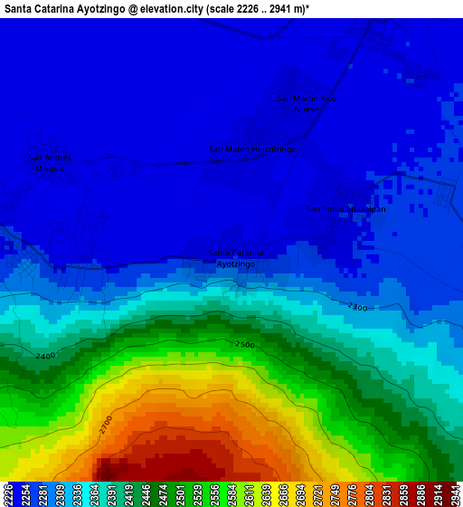
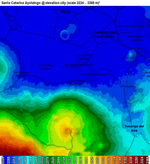
Below is the Elevation map of Santa Catarina Ayotzingo, which displays elevation range with different colors. Scale of the first map is from 2226 to 2941 m (7303 to 9649 ft) with average elevation of 2367 meters (=7766 ft) [note 1]
These maps also provides idea of topography and contour of this city, they are displayed at different zoom levels. More info about maps, scale and edge coordinates you can find below images.
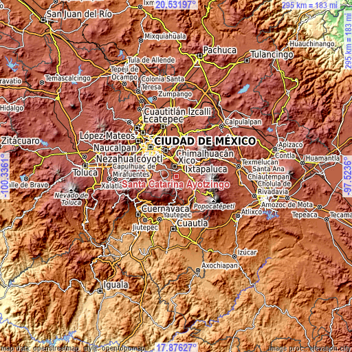
| \ | Map #1 | Map #2 | Topo.Map |
| Scale [m] | 2226..2941 m | 2224..3368 m | × |
| Scale [ft] | 7303..9649 ft | 7297..11050 ft | × |
| Average | 2367 m = 7766 ft | 2422.9 m = 7949 ft | × |
| Width | 9.23 km = 5.7 mi | 18.46 km = 11.5 mi | 295.3 km = 183.5 mi |
| Height | 9.23 km = 5.7 mi | 18.46 km = 11.5 mi | 295.3 km = 183.5 mi |
| ↑Max Latitude | 19.250973° | 19.292456° | 20.53197° |
| Latitude at center | 19.20948° | 19.20948° | 19.20948° |
| ↓Min Latitude | 19.167976° | 19.126462° | 17.87627° |
| ← Min Longitude | -98.973795° | -99.017741° | -100.3361° |
| Longitude center | -98.92985° | -98.92985° | -98.92985° |
| →Max Longitude | -98.885905° | -98.841959° | -97.5236° |
Nearby cities:
Cities around Santa Catarina Ayotzingo sort by population:
• San Antonio Tecómitl elevation 2251 m
6.2 km,  278°
278°
• San Mateo Huitzilzingo 2244 m
2.2 km,  13°
13°
• San Andrés Mixquic 2248 m
4 km,  295°
295°
• San Juan y San Pedro Tezompa 2251 m
3.3 km,  264°
264°
• San Pablo Atlazalpan 2252 m
2.5 km,  69°
69°
• Tetelco 2246 m
4.6 km, 280°
• Zula 2259 m
4.4 km, 74°
• Barrio de Guadalupe 2238 m
2.3 km,  357°
357°
• Caserío de Cortés 2318 m
2.9 km,  244°
244°
• Lomas de San Pablo 2304 m
1.5 km,  121°
121°
• Los Reyes Acatlixhuayán 2267 m
5 km,  90°
90°
• El Recodo de San José Axalco 2285 m
2.9 km,  104°
104°
Multilingual:
 En español:
Santa Catarina Ayotzingo elevación 2246 m.
 En France:
Santa Catarina Ayotzingo élévation 2246 m.
 Auf Deutsch:
Santa Catarina Ayotzingo höhe über dem Meeresspiegel ist 2246 m.
 На русском:
Santa Catarina Ayotzingo высота над уровнем моря 2246 м
Sources and notes:
- [note 1] Map square and city borders are not equal. Map elevation data is calculated only from area inside that square.
- [src 1] Elevation data from geonames database provided with same terms of usage.
- [src 2] The elevation map of Santa Catarina Ayotzingo is generated using elevation data from NASA's 3 arcsec (90m) resolution SRTM data.
- [src 3] Base (background) map © OpenStreetMap contributors tiles are generated by Geofabrik and OpenTopoMap.
Copyright & License:
This Santa Catarina Ayotzingo Elevation Map is licensed under CC BY-SA. You may reuse any part from this page, if you give a proper credit by linking to this URL:
 More info on terms of use page.