Ahuatempan elevation
Ahuatempan (Puebla, Santa Inés Ahuatempan), Mexico elevation is 1813 meters and Ahuatempan elevation in feet is 5948 ft above sea level [src 1]. Ahuatempan is a populated place (feature code) with elevation that is 499 meters (1637 ft) bigger than average city elevation in Mexico.
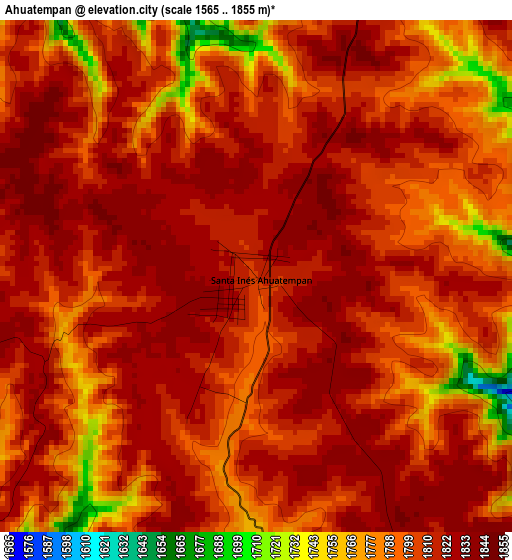
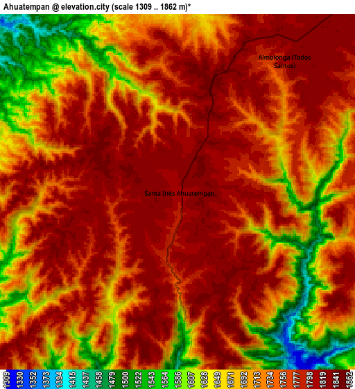
Below is the Elevation map of Ahuatempan, which displays elevation range with different colors. Scale of the first map is from 1565 to 1855 m (5135 to 6086 ft) with average elevation of 1807.2 meters (=5929 ft) [note 1]
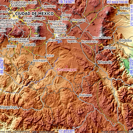
These maps also provides idea of topography and contour of this city, they are displayed at different zoom levels. More info about maps, scale and edge coordinates you can find below images.
| \ | Map #1 | Map #2 | Topo.Map |
| Scale [m] | 1565..1855 m | 1309..1862 m | × |
| Scale [ft] | 5135..6086 ft | 4295..6109 ft | × |
| Average | 1807.2 m = 5929 ft | 1736.7 m = 5698 ft | × |
| Width | 9.27 km = 5.8 mi | 18.54 km = 11.5 mi | 296.7 km = 184.4 mi |
| Height | 9.27 km = 5.8 mi | 18.54 km = 11.5 mi | 296.7 km = 184.4 mi |
| ↑Max Latitude | 18.454381° | 18.496061° | 19.74167° |
| Latitude at center | 18.41269° | 18.41269° | 18.41269° |
| ↓Min Latitude | 18.370989° | 18.329279° | 17.07337° |
| ← Min Longitude | -98.062445° | -98.106391° | -99.42475° |
| Longitude center | -98.0185° | -98.0185° | -98.0185° |
| →Max Longitude | -97.974555° | -97.930609° | -96.61225° |
Nearby cities:
Cities around Ahuatempan sort by population:
• San Juan Ixcaquixtla elevation 1913 m
20.5 km,  74°
74°
• San Vicente Boquerón 1286 m
15.3 km,  194°
194°
• Huajoyuca 1834 m
14 km,  37°
37°
• San Felipe Otlaltepec 1855 m
11.7 km,  96°
96°
• Huejonapan 1797 m
12 km,  58°
58°
• Almolonga 1837 m
9.1 km, 39°
• San Vicente Coyotepec 1897 m
20 km,  92°
92°
• San Pedro Cuayuca 1226 m
19 km,  293°
293°
• Xayacatlán de Bravo 1251 m
20 km,  166°
166°
• Tula 1839 m
18.1 km, 39°
• Hermenegildo Galeana 1382 m
19.5 km,  206°
206°
• Tetelcingo 1208 m
19.3 km,  182°
182°
Multilingual:
 En español:
Ahuatempan elevación 1813 m.
 En France:
Ahuatempan élévation 1813 m.
 Auf Deutsch:
Ahuatempan höhe über dem Meeresspiegel ist 1813 m.

Sources and notes:
- [note 1] Map square and city borders are not equal. Map elevation data is calculated only from area inside that square.
- [src 1] Elevation data from geonames database provided with same terms of usage.
- [src 2] The elevation map of Ahuatempan is generated using elevation data from NASA's 3 arcsec (90m) resolution SRTM data.
- [src 3] Base (background) map © OpenStreetMap contributors tiles are generated by Geofabrik and OpenTopoMap.
Copyright & License:
This Ahuatempan Elevation Map is licensed under CC BY-SA. You may reuse any part from this page, if you give a proper credit by linking to this URL:
 More info on terms of use page.