Santa María elevation
Santa María (State of Mexico, Chapa de Mota), Mexico elevation is 2619 meters and Santa María elevation in feet is 8593 ft above sea level [src 1]. Santa María is a populated place (feature code) with elevation that is 1305 meters (4281 ft) bigger than average city elevation in Mexico.
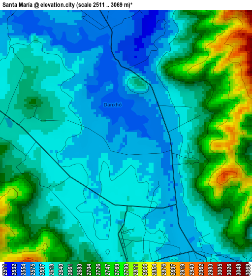
Below is the Elevation map of Santa María, which displays elevation range with different colors. Scale of the first map is from 2511 to 3069 m (8238 to 10069 ft) with average elevation of 2649.3 meters (=8692 ft) [note 1]
These maps also provides idea of topography and contour of this city, they are displayed at different zoom levels. More info about maps, scale and edge coordinates you can find below images.
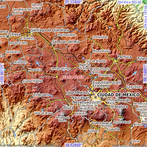
| \ | Map #1 | Topo.Map |
| Scale [m] | 2511..3069 m | × |
| Scale [ft] | 8238..10069 ft | × |
| Average | 2649.3 m = 8692 ft | × |
| Width | 9.19 km = 5.7 mi | 294.1 km = 182.7 mi |
| Height | 9.19 km = 5.7 mi | 294.1 km = 182.7 mi |
| ↑Max Latitude | 19.898367° | 21.17406° |
| Latitude at center | 19.85704° | 19.85704° |
| ↓Min Latitude | 19.815702° | 18.52899° |
| ← Min Longitude | -99.598805° | -100.96111° |
| Longitude center | -99.55486° | -99.55486° |
| →Max Longitude | -99.510915° | -98.14861° |
Nearby cities:
Cities around Santa María sort by population:
• San Felipe Coamango elevation 2661 m
5.4 km,  272°
272°
• San Juan Tuxtepec 2734 m
8.2 km, 271°
• Dongu 2654 m
3.7 km,  244°
244°
• Las Manzanas 2552 m
10.4 km,  356°
356°
• Doxhicho 2502 m
4.8 km, 356°
• Coscomate del Progreso 2479 m
9.4 km,  23°
23°
• Ejido de Coscomate del Progreso 2497 m
8.6 km,  5°
5°
• La Esperanza 2609 m
2.6 km,  169°
169°
• Denjhi 2516 m
7.4 km, 15°
• Tenjay 2654 m
5.5 km,  177°
177°
• El Magueyal 2591 m
9.7 km,  347°
347°
• Chapa de Mota 2619 m
5.6 km,  147°
147°
Multilingual:
 En español:
Santa María elevación 2619 m.
 En France:
Santa María élévation 2619 m.
 Auf Deutsch:
Santa María höhe über dem Meeresspiegel ist 2619 m.

Sources and notes:
- [note 1] Map square and city borders are not equal. Map elevation data is calculated only from area inside that square.
- [src 1] Elevation data from geonames database provided with same terms of usage.
- [src 2] The elevation map of Santa María is generated using elevation data from NASA's 3 arcsec (90m) resolution SRTM data.
- [src 3] Base (background) map © OpenStreetMap contributors tiles are generated by Geofabrik and OpenTopoMap.
Copyright & License:
This Santa María Elevation Map is licensed under CC BY-SA. You may reuse any part from this page, if you give a proper credit by linking to this URL:
 More info on terms of use page.