Santa Teresa elevation
Santa Teresa (Hidalgo, Yahualica), Mexico elevation is 317 meters and Santa Teresa elevation in feet is 1040 ft above sea level [src 1]. Santa Teresa is a populated place (feature code) with elevation that is 997 meters (3271 ft) smaller than average city elevation in Mexico.
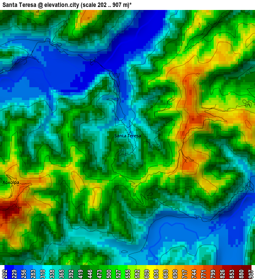
Below is the Elevation map of Santa Teresa, which displays elevation range with different colors. Scale of the first map is from 202 to 907 m (663 to 2976 ft) with average elevation of 432.8 meters (=1420 ft) [note 1]
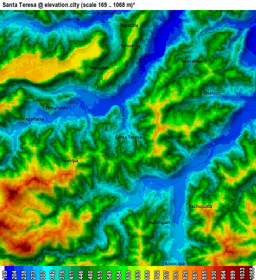
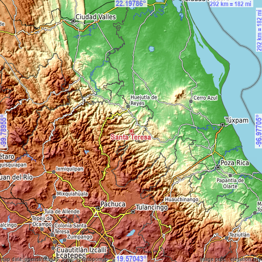
These maps also provides idea of topography and contour of this city, they are displayed at different zoom levels. More info about maps, scale and edge coordinates you can find below images.
| \ | Map #1 | Map #2 | Topo.Map |
| Scale [m] | 202..907 m | 169..1068 m | × |
| Scale [ft] | 663..2976 ft | 554..3504 ft | × |
| Average | 432.8 m = 1420 ft | 473.9 m = 1555 ft | × |
| Width | 9.13 km = 5.7 mi | 18.26 km = 11.3 mi | 292.1 km = 181.5 mi |
| Height | 9.13 km = 5.7 mi | 18.26 km = 11.3 mi | 292.2 km = 181.6 mi |
| ↑Max Latitude | 20.930941° | 20.971981° | 22.19786° |
| Latitude at center | 20.88989° | 20.88989° | 20.88989° |
| ↓Min Latitude | 20.848828° | 20.807754° | 19.57043° |
| ← Min Longitude | -98.427245° | -98.471191° | -99.78955° |
| Longitude center | -98.3833° | -98.3833° | -98.3833° |
| →Max Longitude | -98.339355° | -98.295409° | -96.97705° |
Nearby cities:
Cities around Santa Teresa sort by population:
• Papatlatla elevation 296 m
7.2 km,  280°
280°
• Tlalchiyahualica 230 m
9.2 km,  349°
349°
• Mecatlán 453 m
5.5 km,  338°
338°
• Pahactla 338 m
9.8 km,  16°
16°
• Yahualica 676 m
7.1 km,  2°
2°
• Tecacahuaco 334 m
7.3 km,  38°
38°
• Zoquitipán 297 m
5.5 km,  292°
292°
• Oxeloco 353 m
6.8 km,  61°
61°
• Xoxolpa 629 m
4.5 km,  249°
249°
• Tepetitla 485 m
8 km,  359°
359°
• Pachiquita 692 m
7 km,  134°
134°
• Xococapa 317 m
9.6 km,  159°
159°
Multilingual:
 En español:
Santa Teresa elevación 317 m.
 En France:
Santa Teresa élévation 317 m.
 Auf Deutsch:
Santa Teresa höhe über dem Meeresspiegel ist 317 m.

Sources and notes:
- [note 1] Map square and city borders are not equal. Map elevation data is calculated only from area inside that square.
- [src 1] Elevation data from geonames database provided with same terms of usage.
- [src 2] The elevation map of Santa Teresa is generated using elevation data from NASA's 3 arcsec (90m) resolution SRTM data.
- [src 3] Base (background) map © OpenStreetMap contributors tiles are generated by Geofabrik and OpenTopoMap.
Copyright & License:
This Santa Teresa Elevation Map is licensed under CC BY-SA. You may reuse any part from this page, if you give a proper credit by linking to this URL:
 More info on terms of use page.