Santiago Laxopa elevation
Santiago Laxopa (Oaxaca), Mexico elevation is 1962 meters and Santiago Laxopa elevation in feet is 6437 ft above sea level [src 1]. Santiago Laxopa is a seat of a second-order administrative division (feature code) with elevation that is 648 meters (2126 ft) bigger than average city elevation in Mexico.
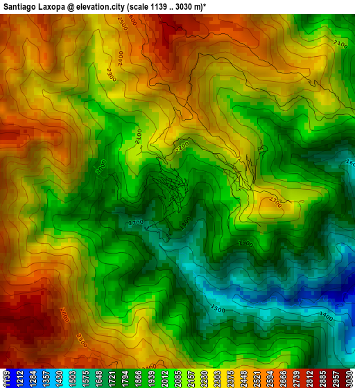
Below is the Elevation map of Santiago Laxopa, which displays elevation range with different colors. Scale of the first map is from 1139 to 3030 m (3737 to 9941 ft) with average elevation of 2127.7 meters (=6981 ft) [note 1]
These maps also provides idea of topography and contour of this city, they are displayed at different zoom levels. More info about maps, scale and edge coordinates you can find below images.
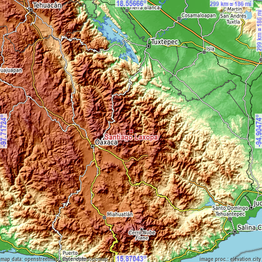
| \ | Map #1 | Topo.Map |
| Scale [m] | 1139..3030 m | × |
| Scale [ft] | 3737..9941 ft | × |
| Average | 2127.7 m = 6981 ft | × |
| Width | 9.33 km = 5.8 mi | 298.7 km = 185.6 mi |
| Height | 9.33 km = 5.8 mi | 298.7 km = 185.6 mi |
| ↑Max Latitude | 17.260391° | 18.55666° |
| Latitude at center | 17.21842° | 17.21842° |
| ↓Min Latitude | 17.176439° | 15.87043° |
| ← Min Longitude | -96.354935° | -97.71724° |
| Longitude center | -96.31099° | -96.31099° |
| →Max Longitude | -96.267045° | -94.90474° |
Nearby cities:
Cities around Santiago Laxopa sort by population:
• San Juan Tabaá elevation 1308 m
14.6 km,  48°
48°
• Cajonos 1864 m
7.7 km,  136°
136°
• Yaganiza 1461 m
11.9 km,  133°
133°
• Xagacía 1640 m
8.5 km,  147°
147°
• San Andrés Solaga 1541 m
10 km, 52°
• San Mateo Cajonos 1380 m
12.7 km,  120°
120°
• Santa María Yavesía 2016 m
12.8 km,  278°
278°
• Santiago Zoochila 1527 m
7.3 km,  88°
88°
• Yalina 1877 m
5.7 km,  65°
65°
• San Francisco Cajonos 1689 m
8.3 km, 129°
• Yatzachi 1590 m
9.6 km, 85°
• Zoogocho 1530 m
7.6 km, 71°
Multilingual:
 En español:
Santiago Laxopa elevación 1962 m.
 En France:
Santiago Laxopa élévation 1962 m.
 Auf Deutsch:
Santiago Laxopa höhe über dem Meeresspiegel ist 1962 m.

Sources and notes:
- [note 1] Map square and city borders are not equal. Map elevation data is calculated only from area inside that square.
- [src 1] Elevation data from geonames database provided with same terms of usage.
- [src 2] The elevation map of Santiago Laxopa is generated using elevation data from NASA's 3 arcsec (90m) resolution SRTM data.
- [src 3] Base (background) map © OpenStreetMap contributors tiles are generated by Geofabrik and OpenTopoMap.
Copyright & License:
This Santiago Laxopa Elevation Map is licensed under CC BY-SA. You may reuse any part from this page, if you give a proper credit by linking to this URL:
 More info on terms of use page.