Santiago Michac elevation
Santiago Michac (Tlaxcala, Natívitas), Mexico elevation is 2199 meters and Santiago Michac elevation in feet is 7215 ft above sea level [src 1]. Santiago Michac is a populated place (feature code) with elevation that is 885 meters (2904 ft) bigger than average city elevation in Mexico.
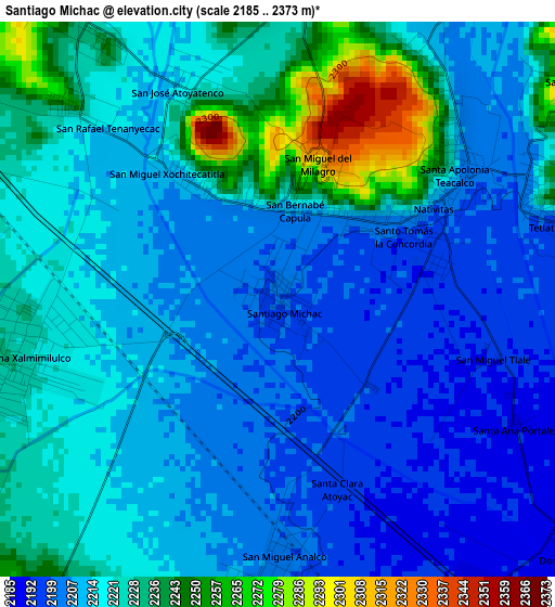
Below is the Elevation map of Santiago Michac, which displays elevation range with different colors. Scale of the first map is from 2185 to 2373 m (7169 to 7785 ft) with average elevation of 2217.8 meters (=7276 ft) [note 1]
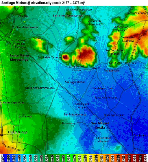
These maps also provides idea of topography and contour of this city, they are displayed at different zoom levels. More info about maps, scale and edge coordinates you can find below images.
| \ | Map #1 | Map #2 | Topo.Map |
| Scale [m] | 2185..2373 m | 2177..2373 m | × |
| Scale [ft] | 7169..7785 ft | 7142..7785 ft | × |
| Average | 2217.8 m = 7276 ft | 2228.7 m = 7312 ft | × |
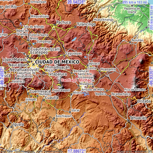
| Width | 9.23 km = 5.7 mi | 18.46 km = 11.5 mi | 295.3 km = 183.5 mi |
| Height | 9.23 km = 5.7 mi | 18.46 km = 11.5 mi | 295.3 km = 183.5 mi |
| ↑Max Latitude | 19.261341° | 19.302821° | 20.54225° |
| Latitude at center | 19.21985° | 19.21985° | 19.21985° |
| ↓Min Latitude | 19.178349° | 19.136837° | 17.88672° |
| ← Min Longitude | -98.383265° | -98.427211° | -99.74557° |
| Longitude center | -98.33932° | -98.33932° | -98.33932° |
| →Max Longitude | -98.295375° | -98.251429° | -96.93307° |
Nearby cities:
Cities around Santiago Michac sort by population:
• Santa Ana Xalmimilulco elevation 2224 m
4.6 km,  260°
260°
• Tlaltenango 2210 m
5.4 km,  181°
181°
• Santa Apolonia Teacalco 2213 m
3.8 km,  50°
50°
• Tetlatlahuca 2205 m
4.8 km,  73°
73°
• Santo Tomás la Concordia 2199 m
2.3 km,  63°
63°
• San Rafael Tenanyecac 2223 m
4.6 km,  312°
312°
• San Miguel Xochitecatitla 2219 m
2.6 km,  323°
323°
• San José Atoyatenco 2217 m
3.8 km,  334°
334°
• San Miguel Analco 2200 m
4.3 km, 180°
• Natívitas 2199 m
3 km, 59°
• San Miguel del Milagro 2299 m
2.5 km,  14°
14°
• Jesús Tepactepec 2199 m
2.8 km, 68°
Multilingual:
 En español:
Santiago Michac elevación 2199 m.
 En France:
Santiago Michac élévation 2199 m.
 Auf Deutsch:
Santiago Michac höhe über dem Meeresspiegel ist 2199 m.

Sources and notes:
- [note 1] Map square and city borders are not equal. Map elevation data is calculated only from area inside that square.
- [src 1] Elevation data from geonames database provided with same terms of usage.
- [src 2] The elevation map of Santiago Michac is generated using elevation data from NASA's 3 arcsec (90m) resolution SRTM data.
- [src 3] Base (background) map © OpenStreetMap contributors tiles are generated by Geofabrik and OpenTopoMap.
Copyright & License:
This Santiago Michac Elevation Map is licensed under CC BY-SA. You may reuse any part from this page, if you give a proper credit by linking to this URL:
 More info on terms of use page.