Santo Tomás Chautla elevation
Santo Tomás Chautla (Puebla), Mexico elevation is 2155 meters and Santo Tomás Chautla elevation in feet is 7070 ft above sea level [src 1]. Santo Tomás Chautla is a populated place (feature code) with elevation that is 841 meters (2759 ft) bigger than average city elevation in Mexico.
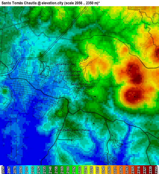
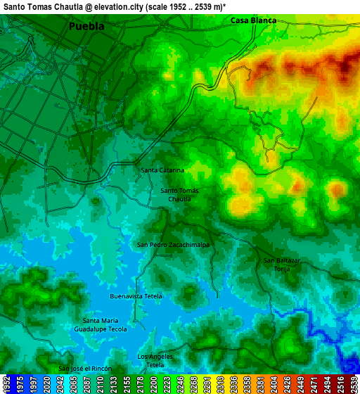
Below is the Elevation map of Santo Tomás Chautla, which displays elevation range with different colors. Scale of the first map is from 2056 to 2350 m (6745 to 7710 ft) with average elevation of 2145.1 meters (=7038 ft) [note 1]
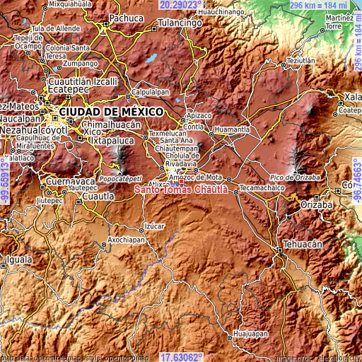
These maps also provides idea of topography and contour of this city, they are displayed at different zoom levels. More info about maps, scale and edge coordinates you can find below images.
| \ | Map #1 | Map #2 | Topo.Map |
| Scale [m] | 2056..2350 m | 1952..2539 m | × |
| Scale [ft] | 6745..7710 ft | 6404..8330 ft | × |
| Average | 2145.1 m = 7038 ft | 2151.2 m = 7058 ft | × |
| Width | 9.24 km = 5.7 mi | 18.48 km = 11.5 mi | 295.7 km = 183.7 mi |
| Height | 9.24 km = 5.7 mi | 18.48 km = 11.5 mi | 295.7 km = 183.7 mi |
| ↑Max Latitude | 19.007284° | 19.048829° | 20.29023° |
| Latitude at center | 18.96573° | 18.96573° | 18.96573° |
| ↓Min Latitude | 18.924165° | 18.88259° | 17.63062° |
| ← Min Longitude | -98.196825° | -98.240771° | -99.55913° |
| Longitude center | -98.15288° | -98.15288° | -98.15288° |
| →Max Longitude | -98.108935° | -98.064989° | -96.74663° |
Nearby cities:
Cities around Santo Tomás Chautla sort by population:
• Puebla elevation 2143 m
9.6 km,  326°
326°
• Casa Blanca 2232 m
9.2 km,  22°
22°
• San Andrés Azumiatla 2142 m
12.5 km,  236°
236°
• San Pedro Zacachimalpa 2151 m
2.6 km,  187°
187°
• Galaxia la Calera 2188 m
3.7 km,  0°
0°
• Los Ángeles Tetela 2116 m
8.6 km, 190°
• Primero de Mayo 2337 m
14.1 km, 24°
• Santa María Guadalupe Tecola 2078 m
8 km,  214°
214°
• Artículo Primero Constitucional 2154 m
1.1 km, 327°
• Buenavista Tetela 2074 m
5.7 km, 205°
• 18 de Marzo 2124 m
0.9 km,  294°
294°
• El Capulo (La Quebradora) 2078 m
12.3 km,  261°
261°
Multilingual:
 En español:
Santo Tomás Chautla elevación 2155 m.
 En France:
Santo Tomás Chautla élévation 2155 m.
 Auf Deutsch:
Santo Tomás Chautla höhe über dem Meeresspiegel ist 2155 m.
 На русском:
Santo Tomás Chautla высота над уровнем моря 2155 м
Sources and notes:
- [note 1] Map square and city borders are not equal. Map elevation data is calculated only from area inside that square.
- [src 1] Elevation data from geonames database provided with same terms of usage.
- [src 2] The elevation map of Santo Tomás Chautla is generated using elevation data from NASA's 3 arcsec (90m) resolution SRTM data.
- [src 3] Base (background) map © OpenStreetMap contributors tiles are generated by Geofabrik and OpenTopoMap.
Copyright & License:
This Santo Tomás Chautla Elevation Map is licensed under CC BY-SA. You may reuse any part from this page, if you give a proper credit by linking to this URL:
 More info on terms of use page.