Soltepec elevation
Soltepec (Puebla), Mexico elevation is 2429 meters and Soltepec elevation in feet is 7969 ft above sea level [src 1]. Soltepec is a populated place (feature code) with elevation that is 1115 meters (3658 ft) bigger than average city elevation in Mexico.
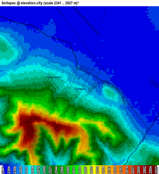
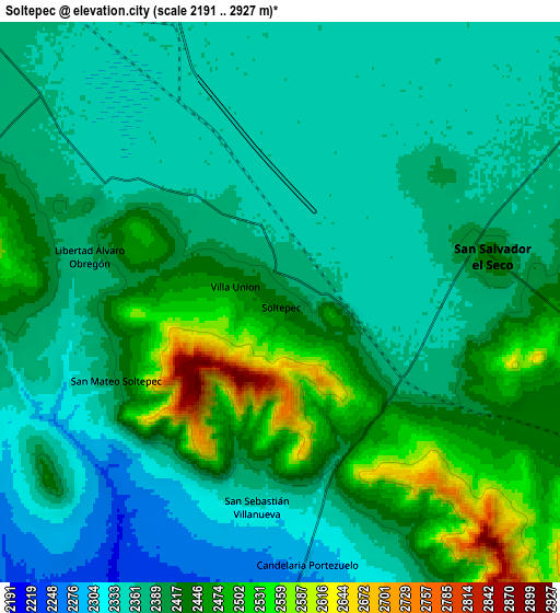
Below is the Elevation map of Soltepec, which displays elevation range with different colors. Scale of the first map is from 2341 to 2927 m (7680 to 9603 ft) with average elevation of 2462.5 meters (=8079 ft) [note 1]
These maps also provides idea of topography and contour of this city, they are displayed at different zoom levels. More info about maps, scale and edge coordinates you can find below images.
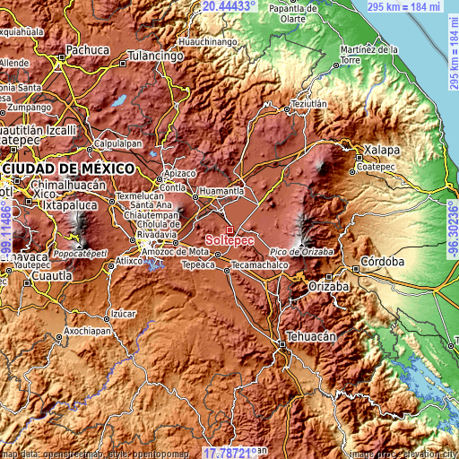
| \ | Map #1 | Map #2 | Topo.Map |
| Scale [m] | 2341..2927 m | 2191..2927 m | × |
| Scale [ft] | 7680..9603 ft | 7188..9603 ft | × |
| Average | 2462.5 m = 8079 ft | 2404.2 m = 7888 ft | × |
| Width | 9.23 km = 5.7 mi | 18.47 km = 11.5 mi | 295.4 km = 183.6 mi |
| Height | 9.23 km = 5.7 mi | 18.47 km = 11.5 mi | 295.5 km = 183.6 mi |
| ↑Max Latitude | 19.162626° | 19.204131° | 20.44433° |
| Latitude at center | 19.12111° | 19.12111° | 19.12111° |
| ↓Min Latitude | 19.079584° | 19.038048° | 17.78721° |
| ← Min Longitude | -97.752555° | -97.796501° | -99.11486° |
| Longitude center | -97.70861° | -97.70861° | -97.70861° |
| →Max Longitude | -97.664665° | -97.620719° | -96.30236° |
Nearby cities:
Cities around Soltepec sort by population:
• San Salvador El Seco elevation 2437 m
7.2 km,  79°
79°
• Santa María Ixtiyucán 2429 m
13 km,  304°
304°
• San Sebastián Villanueva 2335 m
6.8 km,  189°
189°
• Santa Maria Coatepec 2504 m
12.3 km,  96°
96°
• San Antonio Portezuelo 2175 m
13.6 km,  182°
182°
• San Sebastián Teteles 2242 m
13.1 km,  221°
221°
• San José Ozumba 2359 m
12.6 km,  350°
350°
• San Mateo Soltepec 2405 m
6 km,  245°
245°
• Mazapiltepec 2413 m
0.6 km,  109°
109°
• Libertad Álvaro Obregón 2395 m
6.3 km,  283°
283°
• Guadalupe Victoria 2443 m
11 km, 99°
• Candelaria Portezuelo 2280 m
8.8 km,  174°
174°
Multilingual:
 En español:
Soltepec elevación 2429 m.
 En France:
Soltepec élévation 2429 m.
 Auf Deutsch:
Soltepec höhe über dem Meeresspiegel ist 2429 m.

Sources and notes:
- [note 1] Map square and city borders are not equal. Map elevation data is calculated only from area inside that square.
- [src 1] Elevation data from geonames database provided with same terms of usage.
- [src 2] The elevation map of Soltepec is generated using elevation data from NASA's 3 arcsec (90m) resolution SRTM data.
- [src 3] Base (background) map © OpenStreetMap contributors tiles are generated by Geofabrik and OpenTopoMap.
Copyright & License:
This Soltepec Elevation Map is licensed under CC BY-SA. You may reuse any part from this page, if you give a proper credit by linking to this URL:
 More info on terms of use page.