Tacotalpa elevation
Tacotalpa (Tabasco), Mexico elevation is 24 meters and Tacotalpa elevation in feet is 79 ft above sea level [src 1]. Tacotalpa is a seat of a second-order administrative division (feature code) with elevation that is 1290 meters (4232 ft) smaller than average city elevation in Mexico.
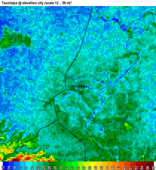
Below is the Elevation map of Tacotalpa, which displays elevation range with different colors. Scale of the first map is from 12 to 58 m (39 to 190 ft) with average elevation of 22 meters (=72 ft) [note 1]
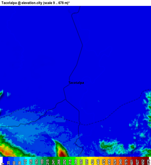
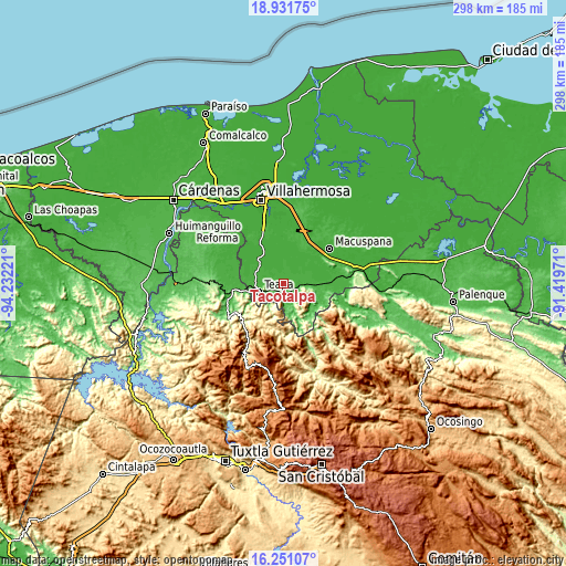
These maps also provides idea of topography and contour of this city, they are displayed at different zoom levels. More info about maps, scale and edge coordinates you can find below images.
| \ | Map #1 | Map #2 | Topo.Map |
| Scale [m] | 12..58 m | 9..678 m | × |
| Scale [ft] | 39..190 ft | 30..2224 ft | × |
| Average | 22 m = 72 ft | 34.6 m = 114 ft | × |
| Width | 9.32 km = 5.8 mi | 18.63 km = 11.6 mi | 298.1 km = 185.2 mi |
| Height | 9.32 km = 5.8 mi | 18.63 km = 11.6 mi | 298.1 km = 185.2 mi |
| ↑Max Latitude | 17.638264° | 17.680139° | 18.93175° |
| Latitude at center | 17.59638° | 17.59638° | 17.59638° |
| ↓Min Latitude | 17.554486° | 17.512582° | 16.25107° |
| ← Min Longitude | -92.869905° | -92.913851° | -94.23221° |
| Longitude center | -92.82596° | -92.82596° | -92.82596° |
| →Max Longitude | -92.782015° | -92.738069° | -91.41971° |
Nearby cities:
Cities around Tacotalpa sort by population:
• Teapa elevation 48 m
14.3 km,  248°
248°
• Río de Teapa 12 m
22.2 km,  339°
339°
• Jalapa 16 m
14 km,  5°
5°
• Juan Aldama 21 m
21.5 km,  273°
273°
• Tapijulapa 54 m
15.7 km,  161°
161°
• Vicente Guerrero 87 m
13.8 km,  227°
227°
• Eureka y Belén 52 m
11.7 km, 249°
• La Gloria 659 m
21.8 km,  218°
218°
• Xicoténcatl 43 m
15.5 km,  124°
124°
• Puxcatán 58 m
21.9 km,  137°
137°
• Ixtapangajoya 106 m
21.6 km,  239°
239°
• Astapa 15 m
20.7 km,  353°
353°
Multilingual:
 En español:
Tacotalpa elevación 24 m.
 En France:
Tacotalpa élévation 24 m.
 Auf Deutsch:
Tacotalpa höhe über dem Meeresspiegel ist 24 m.

Sources and notes:
- [note 1] Map square and city borders are not equal. Map elevation data is calculated only from area inside that square.
- [src 1] Elevation data from geonames database provided with same terms of usage.
- [src 2] The elevation map of Tacotalpa is generated using elevation data from NASA's 3 arcsec (90m) resolution SRTM data.
- [src 3] Base (background) map © OpenStreetMap contributors tiles are generated by Geofabrik and OpenTopoMap.
Copyright & License:
This Tacotalpa Elevation Map is licensed under CC BY-SA. You may reuse any part from this page, if you give a proper credit by linking to this URL:
 More info on terms of use page.