Tecolutla elevation
Tecolutla (Veracruz), Mexico elevation is 8 meters and Tecolutla elevation in feet is 26 ft above sea level [src 1]. Tecolutla is a seat of a second-order administrative division (feature code) with elevation that is 1306 meters (4285 ft) smaller than average city elevation in Mexico.
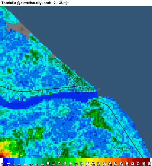
Below is the Elevation map of Tecolutla, which displays elevation range with different colors. Scale of the first map is from -2 to 36 m (-7 to 118 ft) with average elevation of 4.3 meters (=14 ft) [note 1]
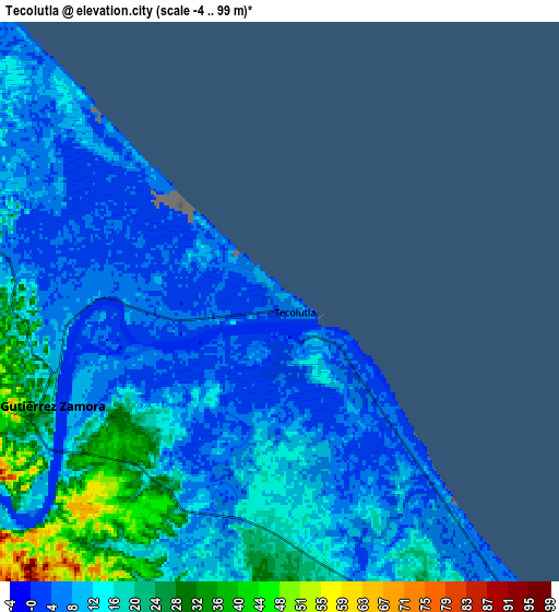
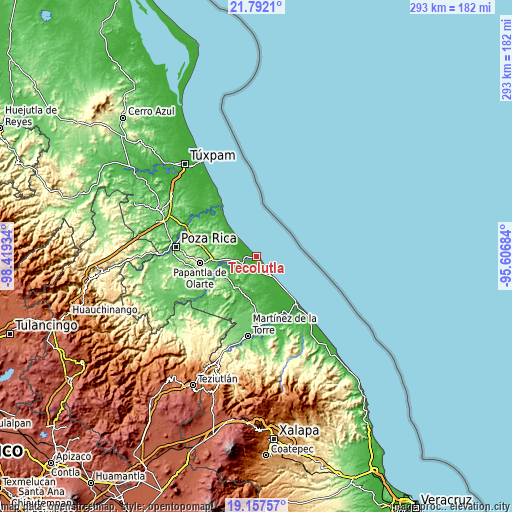
These maps also provides idea of topography and contour of this city, they are displayed at different zoom levels. More info about maps, scale and edge coordinates you can find below images.
| \ | Map #1 | Map #2 | Topo.Map |
| Scale [m] | -2..36 m | -4..99 m | × |
| Scale [ft] | -7..118 ft | -13..325 ft | × |
| Average | 4.3 m = 14 ft | 12.5 m = 41 ft | × |
| Width | 9.15 km = 5.7 mi | 18.31 km = 11.4 mi | 292.9 km = 182 mi |
| Height | 9.15 km = 5.7 mi | 18.31 km = 11.4 mi | 293 km = 182.1 mi |
| ↑Max Latitude | 20.521652° | 20.562803° | 21.7921° |
| Latitude at center | 20.48049° | 20.48049° | 20.48049° |
| ↓Min Latitude | 20.439317° | 20.398133° | 19.15757° |
| ← Min Longitude | -97.057035° | -97.100981° | -98.41934° |
| Longitude center | -97.01309° | -97.01309° | -97.01309° |
| →Max Longitude | -96.969145° | -96.925199° | -95.60684° |
Nearby cities:
Cities around Tecolutla sort by population:
• Gutiérrez Zamora elevation 12 m
8.2 km,  248°
248°
• Hueytepec 28 m
17.2 km,  184°
184°
• El Volador 64 m
30.5 km,  306°
306°
• Carrizal 47 m
28.4 km,  296°
296°
• Carrillo Puerto 32 m
18.6 km, 248°
• Emiliano Zapata 58 m
21.1 km,  237°
237°
• La Guadalupe 10 m
15.4 km,  140°
140°
• El Remolino 108 m
23.1 km, 243°
• Puente de Piedra 9 m
23.6 km, 306°
• Rancho Nuevo 17 m
29.3 km,  316°
316°
• Polutla 144 m
26.1 km,  281°
281°
• La Guásima 61 m
25.5 km, 284°
Multilingual:
 En español:
Tecolutla elevación 8 m.
 En France:
Tecolutla élévation 8 m.


Sources and notes:
- [note 1] Map square and city borders are not equal. Map elevation data is calculated only from area inside that square.
- [src 1] Elevation data from geonames database provided with same terms of usage.
- [src 2] The elevation map of Tecolutla is generated using elevation data from NASA's 3 arcsec (90m) resolution SRTM data.
- [src 3] Base (background) map © OpenStreetMap contributors tiles are generated by Geofabrik and OpenTopoMap.
Copyright & License:
This Tecolutla Elevation Map is licensed under CC BY-SA. You may reuse any part from this page, if you give a proper credit by linking to this URL:
 More info on terms of use page.