Tecozautla elevation
Tecozautla (Hidalgo), Mexico elevation is 1708 meters and Tecozautla elevation in feet is 5604 ft above sea level [src 1]. Tecozautla is a populated place (feature code) with elevation that is 394 meters (1293 ft) bigger than average city elevation in Mexico.
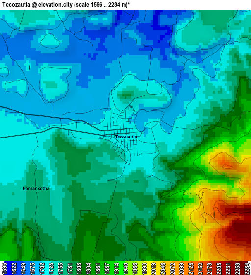
Below is the Elevation map of Tecozautla, which displays elevation range with different colors. Scale of the first map is from 1596 to 2284 m (5236 to 7493 ft) with average elevation of 1776.3 meters (=5828 ft) [note 1]
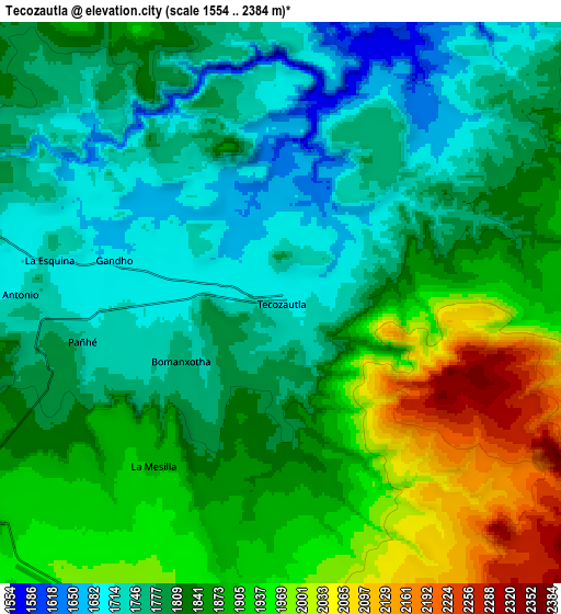
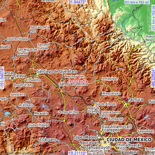
These maps also provides idea of topography and contour of this city, they are displayed at different zoom levels. More info about maps, scale and edge coordinates you can find below images.
| \ | Map #1 | Map #2 | Topo.Map |
| Scale [m] | 1596..2284 m | 1554..2384 m | × |
| Scale [ft] | 5236..7493 ft | 5098..7822 ft | × |
| Average | 1776.3 m = 5828 ft | 1840.9 m = 6040 ft | × |
| Width | 9.15 km = 5.7 mi | 18.3 km = 11.4 mi | 292.8 km = 181.9 mi |
| Height | 9.15 km = 5.7 mi | 18.3 km = 11.4 mi | 292.8 km = 181.9 mi |
| ↑Max Latitude | 20.574738° | 20.615874° | 21.84473° |
| Latitude at center | 20.53359° | 20.53359° | 20.53359° |
| ↓Min Latitude | 20.492431° | 20.451261° | 19.21112° |
| ← Min Longitude | -99.678435° | -99.722381° | -101.04074° |
| Longitude center | -99.63449° | -99.63449° | -99.63449° |
| →Max Longitude | -99.590545° | -99.546599° | -98.22824° |
Nearby cities:
Cities around Tecozautla sort by population:
• Pañhé elevation 1733 m
6.6 km,  258°
258°
• Gandhó 1695 m
5.7 km,  283°
283°
• Bomanxotha 1772 m
3.9 km,  239°
239°
• Mamithi 2035 m
14 km,  190°
190°
• San Francisco 1850 m
12.2 km, 237°
• Bondojito 1963 m
12.1 km,  214°
214°
• San Antonio 1734 m
7.9 km,  268°
268°
• La Mesilla 1888 m
6.6 km,  221°
221°
• La Esquina 1729 m
7.8 km, 281°
• San Joaquín 1961 m
15.1 km, 258°
• Jonacapa 2322 m
15.3 km,  136°
136°
• Dantzibojay 2147 m
11.6 km,  154°
154°
Multilingual:
 En español:
Tecozautla elevación 1708 m.
 En France:
Tecozautla élévation 1708 m.
 Auf Deutsch:
Tecozautla höhe über dem Meeresspiegel ist 1708 m.

Sources and notes:
- [note 1] Map square and city borders are not equal. Map elevation data is calculated only from area inside that square.
- [src 1] Elevation data from geonames database provided with same terms of usage.
- [src 2] The elevation map of Tecozautla is generated using elevation data from NASA's 3 arcsec (90m) resolution SRTM data.
- [src 3] Base (background) map © OpenStreetMap contributors tiles are generated by Geofabrik and OpenTopoMap.
Copyright & License:
This Tecozautla Elevation Map is licensed under CC BY-SA. You may reuse any part from this page, if you give a proper credit by linking to this URL:
 More info on terms of use page.