Teotitlán del Valle elevation
Teotitlán del Valle (Oaxaca), Mexico elevation is 1689 meters and Teotitlán del Valle elevation in feet is 5541 ft above sea level [src 1]. Teotitlán del Valle is a seat of a second-order administrative division (feature code) with elevation that is 375 meters (1230 ft) bigger than average city elevation in Mexico.
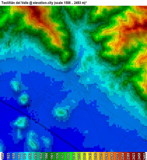
Below is the Elevation map of Teotitlán del Valle, which displays elevation range with different colors. Scale of the first map is from 1588 to 2493 m (5210 to 8179 ft) with average elevation of 1796 meters (=5892 ft) [note 1]
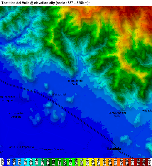
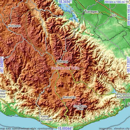
These maps also provides idea of topography and contour of this city, they are displayed at different zoom levels. More info about maps, scale and edge coordinates you can find below images.
| \ | Map #1 | Map #2 | Topo.Map |
| Scale [m] | 1588..2493 m | 1557..3259 m | × |
| Scale [ft] | 5210..8179 ft | 5108..10692 ft | × |
| Average | 1796 m = 5892 ft | 1914.7 m = 6282 ft | × |
| Width | 9.34 km = 5.8 mi | 18.69 km = 11.6 mi | 299 km = 185.8 mi |
| Height | 9.34 km = 5.8 mi | 18.69 km = 11.6 mi | 299 km = 185.8 mi |
| ↑Max Latitude | 17.071764° | 17.113768° | 18.3694° |
| Latitude at center | 17.02975° | 17.02975° | 17.02975° |
| ↓Min Latitude | 16.987727° | 16.945694° | 15.68044° |
| ← Min Longitude | -96.563205° | -96.607151° | -97.92551° |
| Longitude center | -96.51926° | -96.51926° | -96.51926° |
| →Max Longitude | -96.475315° | -96.431369° | -95.11301° |
Nearby cities:
Cities around Teotitlán del Valle sort by population:
• Tlacolula de Matamoros elevation 1625 m
9.5 km,  151°
151°
• San Francisco Lachigoló 1573 m
8.7 km,  260°
260°
• San Juan Guelavía 1600 m
8.7 km,  197°
197°
• San Miguel del Valle 1782 m
10.9 km,  95°
95°
• Villa Díaz Ordaz 1717 m
10 km,  112°
112°
• Macuilxóchitl de Artigas Carranza 1637 m
2.7 km,  234°
234°
• Fraccionamiento Ciudad Yagul 1664 m
8.4 km,  133°
133°
• San Jerónimo Tlacochahuaya 1593 m
7.1 km,  250°
250°
• Santa Ana del Valle 1671 m
6.4 km, 127°
• Santa Cruz Papalutla 1593 m
10.6 km,  219°
219°
• San Sebastián Abasolo 1583 m
8.2 km,  241°
241°
• Santa María Guelacé 1573 m
9.5 km, 250°
Multilingual:
 En español:
Teotitlán del Valle elevación 1689 m.
 En France:
Teotitlán del Valle élévation 1689 m.
 Auf Deutsch:
Teotitlán del Valle höhe über dem Meeresspiegel ist 1689 m.
 На русском:
Teotitlán del Valle высота над уровнем моря 1689 м
Sources and notes:
- [note 1] Map square and city borders are not equal. Map elevation data is calculated only from area inside that square.
- [src 1] Elevation data from geonames database provided with same terms of usage.
- [src 2] The elevation map of Teotitlán del Valle is generated using elevation data from NASA's 3 arcsec (90m) resolution SRTM data.
- [src 3] Base (background) map © OpenStreetMap contributors tiles are generated by Geofabrik and OpenTopoMap.
Copyright & License:
This Teotitlán del Valle Elevation Map is licensed under CC BY-SA. You may reuse any part from this page, if you give a proper credit by linking to this URL:
 More info on terms of use page.