Tetecala elevation
Tetecala (Morelos), Mexico elevation is 986 meters and Tetecala elevation in feet is 3235 ft above sea level [src 1]. Tetecala is a seat of a second-order administrative division (feature code) with elevation that is 328 meters (1076 ft) smaller than average city elevation in Mexico.
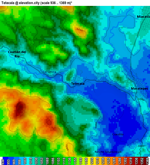
Below is the Elevation map of Tetecala, which displays elevation range with different colors. Scale of the first map is from 936 to 1369 m (3071 to 4491 ft) with average elevation of 1061.4 meters (=3482 ft) [note 1]
These maps also provides idea of topography and contour of this city, they are displayed at different zoom levels. More info about maps, scale and edge coordinates you can find below images.
| \ | Map #1 | Map #2 | Topo.Map |
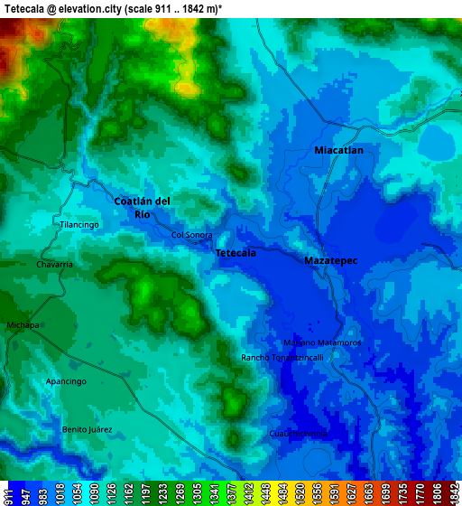
| Scale [m] | 936..1369 m | 911..1842 m | × |
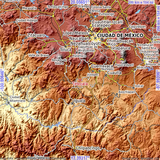
| Scale [ft] | 3071..4491 ft | 2989..6043 ft | × |
| Average | 1061.4 m = 3482 ft | 1093.5 m = 3588 ft | × |
| Width | 9.25 km = 5.7 mi | 18.51 km = 11.5 mi | 296.1 km = 184 mi |
| Height | 9.25 km = 5.7 mi | 18.51 km = 11.5 mi | 296.2 km = 184 mi |
| ↑Max Latitude | 18.771703° | 18.813306° | 20.05651° |
| Latitude at center | 18.73009° | 18.73009° | 18.73009° |
| ↓Min Latitude | 18.688467° | 18.646833° | 17.39317° |
| ← Min Longitude | -99.444155° | -99.488101° | -100.80646° |
| Longitude center | -99.40021° | -99.40021° | -99.40021° |
| →Max Longitude | -99.356265° | -99.312319° | -97.99396° |
Nearby cities:
Cities around Tetecala sort by population:
• Coatetelco elevation 989 m
7.8 km,  90°
90°
• Miacatlán 1032 m
5.6 km,  50°
50°
• Mazatepec 976 m
3.9 km, 93°
• Cuauchichinola 945 m
7.8 km,  160°
160°
• Coatlán del Río 1022 m
3.8 km,  294°
294°
• San Andrés Nicolás Bravo 1193 m
8 km,  301°
301°
• El Mirador 1064 m
7.7 km, 53°
• Cocoyotla 1049 m
6 km, 296°
• El Rodeo 1119 m
9.8 km,  56°
56°
• Michapa 1202 m
8.9 km,  249°
249°
• Colonia el Florido 990 m
3.6 km,  75°
75°
• Chavarría 1162 m
7.2 km,  266°
266°
Multilingual:
 En español:
Tetecala elevación 986 m.
 En France:
Tetecala élévation 986 m.
 Auf Deutsch:
Tetecala höhe über dem Meeresspiegel ist 986 m.

Sources and notes:
- [note 1] Map square and city borders are not equal. Map elevation data is calculated only from area inside that square.
- [src 1] Elevation data from geonames database provided with same terms of usage.
- [src 2] The elevation map of Tetecala is generated using elevation data from NASA's 3 arcsec (90m) resolution SRTM data.
- [src 3] Base (background) map © OpenStreetMap contributors tiles are generated by Geofabrik and OpenTopoMap.
Copyright & License:
This Tetecala Elevation Map is licensed under CC BY-SA. You may reuse any part from this page, if you give a proper credit by linking to this URL:
 More info on terms of use page.