Texca elevation
Texca (Guerrero, Acapulco de Juárez), Mexico elevation is 529 meters and Texca elevation in feet is 1736 ft above sea level [src 1]. Texca is a populated place (feature code) with elevation that is 785 meters (2575 ft) smaller than average city elevation in Mexico.
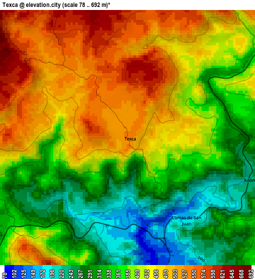
Below is the Elevation map of Texca, which displays elevation range with different colors. Scale of the first map is from 78 to 692 m (256 to 2270 ft) with average elevation of 404.4 meters (=1327 ft) [note 1]
These maps also provides idea of topography and contour of this city, they are displayed at different zoom levels. More info about maps, scale and edge coordinates you can find below images.
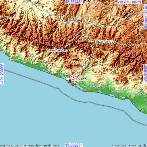
| \ | Map #1 | Topo.Map |
| Scale [m] | 78..692 m | × |
| Scale [ft] | 256..2270 ft | × |
| Average | 404.4 m = 1327 ft | × |
| Width | 9.34 km = 5.8 mi | 299 km = 185.8 mi |
| Height | 9.34 km = 5.8 mi | 299 km = 185.8 mi |
| ↑Max Latitude | 17.053718° | 18.35148° |
| Latitude at center | 17.0117° | 17.0117° |
| ↓Min Latitude | 16.969673° | 15.66227° |
| ← Min Longitude | -99.868685° | -101.23099° |
| Longitude center | -99.82474° | -99.82474° |
| →Max Longitude | -99.780795° | -98.41849° |
Nearby cities:
Cities around Texca sort by population:
• Kilómetro 30 elevation 266 m
5 km,  108°
108°
• Lomas de San Juan 162 m
3.7 km,  143°
143°
• Ejido Nuevo 252 m
10.2 km, 114°
• Sabanillas 235 m
13 km,  95°
95°
• Platanillo 612 m
10.9 km,  302°
302°
• Los Órganos de San Agustín 53 m
8.5 km,  178°
178°
• Valle del Río 31 m
12.5 km,  251°
251°
• Kilómetro 40 410 m
7.1 km,  53°
53°
• Nueva Frontera 26 m
13.8 km, 176°
• Ocotillo 713 m
6.1 km, 295°
• Colonia Nueva Revolución 28 m
12.8 km,  170°
170°
• Colonia Alborada 26 m
14.5 km, 177°
Multilingual:
 En español:
Texca elevación 529 m.
 En France:
Texca élévation 529 m.


Sources and notes:
- [note 1] Map square and city borders are not equal. Map elevation data is calculated only from area inside that square.
- [src 1] Elevation data from geonames database provided with same terms of usage.
- [src 2] The elevation map of Texca is generated using elevation data from NASA's 3 arcsec (90m) resolution SRTM data.
- [src 3] Base (background) map © OpenStreetMap contributors tiles are generated by Geofabrik and OpenTopoMap.
Copyright & License:
This Texca Elevation Map is licensed under CC BY-SA. You may reuse any part from this page, if you give a proper credit by linking to this URL:
 More info on terms of use page.