Tlalixtac de Cabrera elevation
Tlalixtac de Cabrera (Oaxaca), Mexico elevation is 1583 meters and Tlalixtac de Cabrera elevation in feet is 5194 ft above sea level [src 1]. Tlalixtac de Cabrera is a seat of a second-order administrative division (feature code) with elevation that is 269 meters (883 ft) bigger than average city elevation in Mexico.
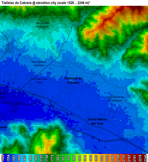
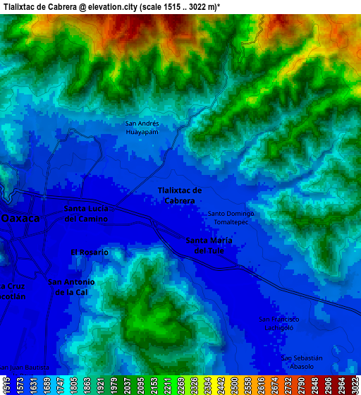
Below is the Elevation map of Tlalixtac de Cabrera, which displays elevation range with different colors. Scale of the first map is from 1526 to 2246 m (5007 to 7369 ft) with average elevation of 1667.6 meters (=5471 ft) [note 1]
These maps also provides idea of topography and contour of this city, they are displayed at different zoom levels. More info about maps, scale and edge coordinates you can find below images.
| \ | Map #1 | Map #2 | Topo.Map |
| Scale [m] | 1526..2246 m | 1515..3022 m | × |
| Scale [ft] | 5007..7369 ft | 4970..9915 ft | × |
| Average | 1667.6 m = 5471 ft | 1825.6 m = 5990 ft | × |
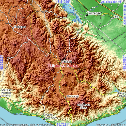
| Width | 9.34 km = 5.8 mi | 18.68 km = 11.6 mi | 298.9 km = 185.7 mi |
| Height | 9.34 km = 5.8 mi | 18.68 km = 11.6 mi | 298.9 km = 185.7 mi |
| ↑Max Latitude | 17.113124° | 17.155119° | 18.41046° |
| Latitude at center | 17.07112° | 17.07112° | 17.07112° |
| ↓Min Latitude | 17.029106° | 16.987083° | 15.7221° |
| ← Min Longitude | -96.691045° | -96.734991° | -98.05335° |
| Longitude center | -96.6471° | -96.6471° | -96.6471° |
| →Max Longitude | -96.603155° | -96.559209° | -95.24085° |
Nearby cities:
Cities around Tlalixtac de Cabrera sort by population:
• Oaxaca elevation 1567 m
8.2 km,  265°
265°
• San Antonio de la Cal 1550 m
7.4 km,  230°
230°
• El Rosario 1558 m
5.7 km,  236°
236°
• Santa Cruz Amilpas 1544 m
4.1 km,  249°
249°
• Santa María del Tule 1565 m
2.9 km,  155°
155°
• San Sebastián Tutla 1545 m
3.4 km, 245°
• San Andrés Huayápam 1713 m
4 km,  330°
330°
• San Agustín Yatareni 1608 m
2.3 km,  301°
301°
• San Francisco Lachigoló 1573 m
7.9 km,  140°
140°
• San Francisco Tutla 1574 m
2.2 km, 269°
• Santo Domingo Tomaltepec 1587 m
2.8 km,  113°
113°
• Rojas de Cuauhtémoc 1579 m
7.8 km, 157°
Multilingual:
 En español:
Tlalixtac de Cabrera elevación 1583 m.
 En France:
Tlalixtac de Cabrera élévation 1583 m.
 Auf Deutsch:
Tlalixtac de Cabrera höhe über dem Meeresspiegel ist 1583 m.
 На русском:
Tlalixtac de Cabrera высота над уровнем моря 1583 м
Sources and notes:
- [note 1] Map square and city borders are not equal. Map elevation data is calculated only from area inside that square.
- [src 1] Elevation data from geonames database provided with same terms of usage.
- [src 2] The elevation map of Tlalixtac de Cabrera is generated using elevation data from NASA's 3 arcsec (90m) resolution SRTM data.
- [src 3] Base (background) map © OpenStreetMap contributors tiles are generated by Geofabrik and OpenTopoMap.
Copyright & License:
This Tlalixtac de Cabrera Elevation Map is licensed under CC BY-SA. You may reuse any part from this page, if you give a proper credit by linking to this URL:
 More info on terms of use page.