Tlalnepantla elevation
Tlalnepantla (Morelos), Mexico elevation is 2057 meters and Tlalnepantla elevation in feet is 6749 ft above sea level [src 1]. Tlalnepantla is a seat of a second-order administrative division (feature code) with elevation that is 743 meters (2438 ft) bigger than average city elevation in Mexico.
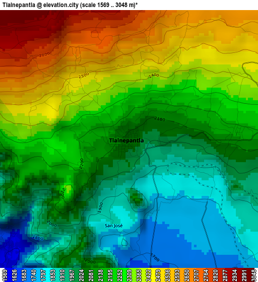
Below is the Elevation map of Tlalnepantla, which displays elevation range with different colors. Scale of the first map is from 1569 to 3048 m (5148 to 10000 ft) with average elevation of 2189.4 meters (=7183 ft) [note 1]
These maps also provides idea of topography and contour of this city, they are displayed at different zoom levels. More info about maps, scale and edge coordinates you can find below images.
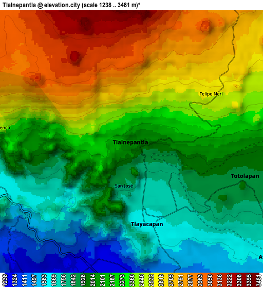
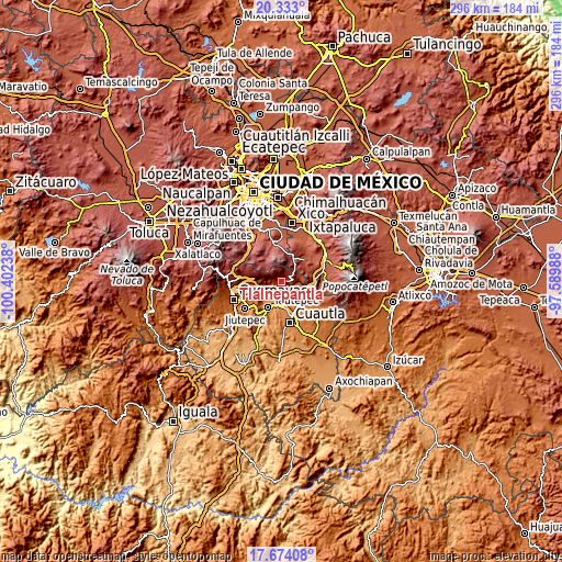
| \ | Map #1 | Map #2 | Topo.Map |
| Scale [m] | 1569..3048 m | 1238..3481 m | × |
| Scale [ft] | 5148..10000 ft | 4062..11421 ft | × |
| Average | 2189.4 m = 7183 ft | 2224 m = 7297 ft | × |
| Width | 9.24 km = 5.7 mi | 18.48 km = 11.5 mi | 295.6 km = 183.7 mi |
| Height | 9.24 km = 5.7 mi | 18.48 km = 11.5 mi | 295.7 km = 183.7 mi |
| ↑Max Latitude | 19.050394° | 19.091927° | 20.333° |
| Latitude at center | 19.00885° | 19.00885° | 19.00885° |
| ↓Min Latitude | 18.967296° | 18.925731° | 17.67408° |
| ← Min Longitude | -99.040075° | -99.084021° | -100.40238° |
| Longitude center | -98.99613° | -98.99613° | -98.99613° |
| →Max Longitude | -98.952185° | -98.908239° | -97.58988° |
Nearby cities:
Cities around Tlalnepantla sort by population:
• Tlayacapan elevation 1637 m
6.1 km,  165°
165°
• Totolapan 1902 m
8.4 km,  108°
108°
• Nepopualco 2043 m
5.7 km,  100°
100°
• Santo Domingo Ocotitlán 2076 m
6.8 km,  275°
275°
• Lázaro Cárdenas (El Empalme) 1285 m
9.1 km,  199°
199°
• Felipe Neri (Cuatepec) 2555 m
6.5 km,  58°
58°
• Cuauhtempan (San Andrés Cuauhtempan) 1860 m
6.5 km,  125°
125°
• Colonia Obrera 1290 m
9.7 km,  207°
207°
• Colonia Ángel Bocanegra (Adolfo López Mateos) 1266 m
9.8 km, 201°
• Ignacio Bastida (Santa Catarina Tlayca) 1302 m
7.9 km,  194°
194°
• Emiliano Zapata (Casahuates) 1518 m
9.5 km,  155°
155°
• Amatlán de Quetzalcoatl 1617 m
5.7 km,  229°
229°
Multilingual:
 En español:
Tlalnepantla elevación 2057 m.
 En France:
Tlalnepantla élévation 2057 m.
 Auf Deutsch:
Tlalnepantla höhe über dem Meeresspiegel ist 2057 m.

Sources and notes:
- [note 1] Map square and city borders are not equal. Map elevation data is calculated only from area inside that square.
- [src 1] Elevation data from geonames database provided with same terms of usage.
- [src 2] The elevation map of Tlalnepantla is generated using elevation data from NASA's 3 arcsec (90m) resolution SRTM data.
- [src 3] Base (background) map © OpenStreetMap contributors tiles are generated by Geofabrik and OpenTopoMap.
Copyright & License:
This Tlalnepantla Elevation Map is licensed under CC BY-SA. You may reuse any part from this page, if you give a proper credit by linking to this URL:
 More info on terms of use page.