Tlapacoyan elevation
Tlapacoyan (Veracruz), Mexico elevation is 446 meters and Tlapacoyan elevation in feet is 1463 ft above sea level [src 1]. Tlapacoyan is a seat of a second-order administrative division (feature code) with elevation that is 868 meters (2848 ft) smaller than average city elevation in Mexico.
Below is the Elevation map of Tlapacoyan, which displays elevation range with different colors. Scale of the first map is from 165 to 874 m (541 to 2867 ft) with average elevation of 447.6 meters (=1469 ft) [note 1]
These maps also provides idea of topography and contour of this city, they are displayed at different zoom levels. More info about maps, scale and edge coordinates you can find below images.
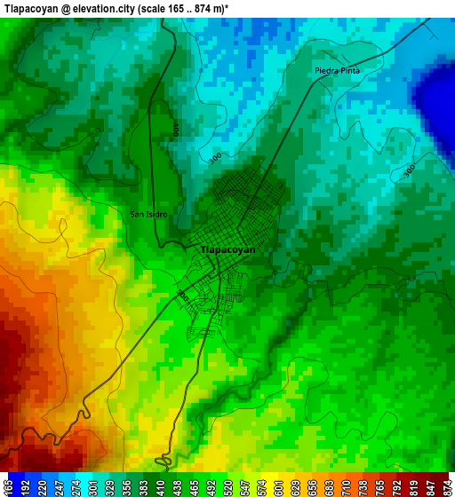
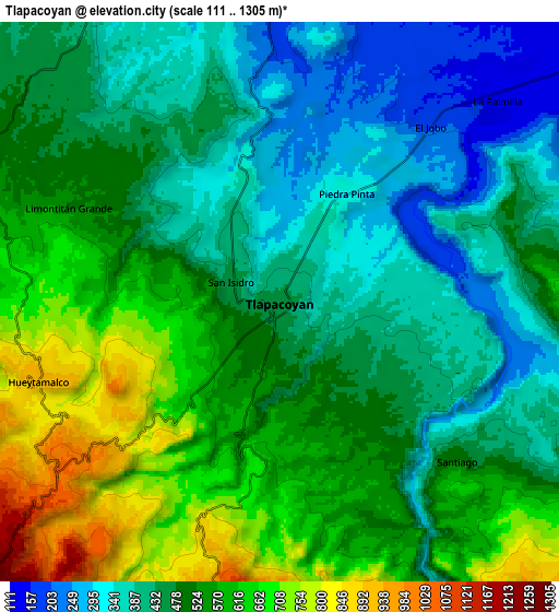
| \ | Map #1 | Map #2 | Topo.Map |
| Scale [m] | 165..874 m | 111..1305 m | × |
| Scale [ft] | 541..2867 ft | 364..4281 ft | × |
| Average | 447.6 m = 1469 ft | 499 m = 1637 ft | × |
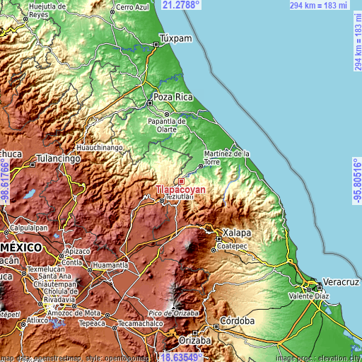
| Width | 9.19 km = 5.7 mi | 18.37 km = 11.4 mi | 293.9 km = 182.6 mi |
| Height | 9.19 km = 5.7 mi | 18.37 km = 11.4 mi | 293.9 km = 182.6 mi |
| ↑Max Latitude | 20.003979° | 20.045268° | 21.2788° |
| Latitude at center | 19.96268° | 19.96268° | 19.96268° |
| ↓Min Latitude | 19.92137° | 19.880049° | 18.63549° |
| ← Min Longitude | -97.255355° | -97.299301° | -98.61766° |
| Longitude center | -97.21141° | -97.21141° | -97.21141° |
| →Max Longitude | -97.167465° | -97.123519° | -95.80516° |
Nearby cities:
Cities around Tlapacoyan sort by population:
• Hueytamalco elevation 922 m
8.4 km,  252°
252°
• La Palmilla 147 m
9.4 km,  47°
47°
• Plan de Arroyos 793 m
13.2 km,  125°
125°
• San Salvador (Naranjillo) 1749 m
18.2 km,  216°
216°
• El Jobo 194 m
7.5 km,  40°
40°
• Piedra Pinta 335 m
3.6 km,  27°
27°
• San Isidro 445 m
1.5 km,  277°
277°
• El Progreso 544 m
17.2 km,  291°
291°
• Pahua Hueca 443 m
16.3 km,  90°
90°
• Santiago 495 m
7.9 km, 130°
• Melchor Ocampo 1688 m
16.9 km, 216°
• San Pedro Tlapacoyan 109 m
15.9 km, 48°
Multilingual:
 En español:
Tlapacoyan elevación 446 m.
 En France:
Tlapacoyan élévation 446 m.
 Auf Deutsch:
Tlapacoyan höhe über dem Meeresspiegel ist 446 m.

Sources and notes:
- [note 1] Map square and city borders are not equal. Map elevation data is calculated only from area inside that square.
- [src 1] Elevation data from geonames database provided with same terms of usage.
- [src 2] The elevation map of Tlapacoyan is generated using elevation data from NASA's 3 arcsec (90m) resolution SRTM data.
- [src 3] Base (background) map © OpenStreetMap contributors tiles are generated by Geofabrik and OpenTopoMap.
Copyright & License:
This Tlapacoyan Elevation Map is licensed under CC BY-SA. You may reuse any part from this page, if you give a proper credit by linking to this URL:
 More info on terms of use page.