San José Toxi elevation
San José Toxi (State of Mexico, Atlacomulco), Mexico elevation is 2496 meters and San José Toxi elevation in feet is 8189 ft above sea level [src 1]. San José Toxi is a populated place (feature code) with elevation that is 1182 meters (3878 ft) bigger than average city elevation in Mexico.
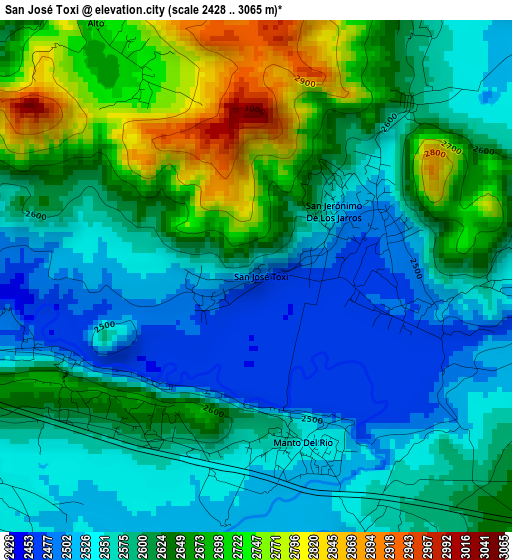
Below is the Elevation map of San José Toxi, which displays elevation range with different colors. Scale of the first map is from 2428 to 3065 m (7966 to 10056 ft) with average elevation of 2604.3 meters (=8544 ft) [note 1]
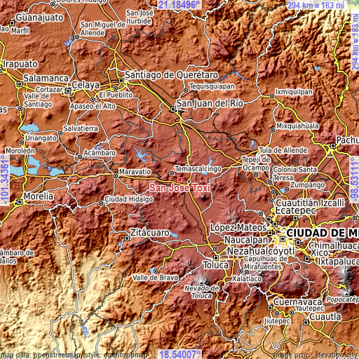
These maps also provides idea of topography and contour of this city, they are displayed at different zoom levels. More info about maps, scale and edge coordinates you can find below images.
| \ | Map #1 | Topo.Map |
| Scale [m] | 2428..3065 m | × |
| Scale [ft] | 7966..10056 ft | × |
| Average | 2604.3 m = 8544 ft | × |
| Width | 9.19 km = 5.7 mi | 294.1 km = 182.7 mi |
| Height | 9.19 km = 5.7 mi | 294.1 km = 182.7 mi |
| ↑Max Latitude | 19.909354° | 21.18496° |
| Latitude at center | 19.86803° | 19.86803° |
| ↓Min Latitude | 19.826695° | 18.54007° |
| ← Min Longitude | -99.981305° | -101.34361° |
| Longitude center | -99.93736° | -99.93736° |
| →Max Longitude | -99.893415° | -98.53111° |
Nearby cities:
Cities around San José Toxi sort by population:
• San Lorenzo Tlacotepec elevation 2544 m
6.7 km,  156°
156°
• San Francisco Tepeolulco 2553 m
6.6 km,  233°
233°
• San Jerónimo de los Jarros 2508 m
1.9 km,  51°
51°
• San Juan de los Jarros 2475 m
2.3 km,  106°
106°
• La Mesa de Chosto 2526 m
5.2 km, 109°
• San Pedro el Alto 2742 m
5.5 km,  329°
329°
• Chosto de los Jarros 2485 m
2.9 km,  100°
100°
• Bobashi de Guadalupe 2517 m
2.8 km,  72°
72°
• San Bartolo Lanzados 2551 m
4.5 km,  92°
92°
• San Mateo el Viejo 2586 m
5.9 km,  28°
28°
• Manto del Río Ejido 2542 m
3.3 km, 161°
• Santo Domingo Shomege (Shomege) 2531 m
4.5 km,  124°
124°
Multilingual:
 En español:
San José Toxi elevación 2496 m.
 En France:
San José Toxi élévation 2496 m.
 Auf Deutsch:
San José Toxi höhe über dem Meeresspiegel ist 2496 m.

Sources and notes:
- [note 1] Map square and city borders are not equal. Map elevation data is calculated only from area inside that square.
- [src 1] Elevation data from geonames database provided with same terms of usage.
- [src 2] The elevation map of San José Toxi is generated using elevation data from NASA's 3 arcsec (90m) resolution SRTM data.
- [src 3] Base (background) map © OpenStreetMap contributors tiles are generated by Geofabrik and OpenTopoMap.
Copyright & License:
This San José Toxi Elevation Map is licensed under CC BY-SA. You may reuse any part from this page, if you give a proper credit by linking to this URL:
 More info on terms of use page.