Santa Rosa Treinta elevation
Santa Rosa Treinta (Morelos, Tlaltizapán de Zapata), Mexico elevation is 990 meters and Santa Rosa Treinta elevation in feet is 3248 ft above sea level [src 1]. Santa Rosa Treinta is a populated place (feature code) with elevation that is 324 meters (1063 ft) smaller than average city elevation in Mexico.
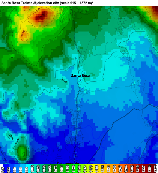
Below is the Elevation map of Santa Rosa Treinta, which displays elevation range with different colors. Scale of the first map is from 915 to 1372 m (3002 to 4501 ft) with average elevation of 1008.9 meters (=3310 ft) [note 1]
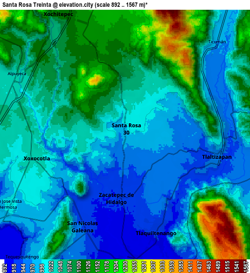
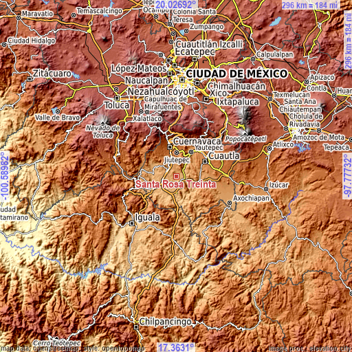
These maps also provides idea of topography and contour of this city, they are displayed at different zoom levels. More info about maps, scale and edge coordinates you can find below images.
| \ | Map #1 | Map #2 | Topo.Map |
| Scale [m] | 915..1372 m | 892..1567 m | × |
| Scale [ft] | 3002..4501 ft | 2927..5141 ft | × |
| Average | 1008.9 m = 3310 ft | 1046.2 m = 3432 ft | × |
| Width | 9.26 km = 5.8 mi | 18.51 km = 11.5 mi | 296.2 km = 184 mi |
| Height | 9.26 km = 5.8 mi | 18.51 km = 11.5 mi | 296.2 km = 184 mi |
| ↑Max Latitude | 18.74187° | 18.78348° | 20.02692° |
| Latitude at center | 18.70025° | 18.70025° | 18.70025° |
| ↓Min Latitude | 18.658619° | 18.616979° | 17.3631° |
| ← Min Longitude | -99.227515° | -99.271461° | -100.58982° |
| Longitude center | -99.18357° | -99.18357° | -99.18357° |
| →Max Longitude | -99.139625° | -99.095679° | -97.77732° |
Nearby cities:
Cities around Santa Rosa Treinta sort by population:
• Zacatepec elevation 922 m
5.2 km,  187°
187°
• Xoxocotla 1032 m
6.8 km,  254°
254°
• Tlaltizapán 952 m
7 km,  102°
102°
• Atlacholoaya 1087 m
6.5 km,  315°
315°
• Huatecalco 947 m
5 km,  121°
121°
• Bonifacio García 970 m
7 km,  73°
73°
• Alfredo V. Bonfil (Chacampalco) 944 m
5.9 km,  148°
148°
• Acamilpa 1002 m
3.3 km,  56°
56°
• Temimilcingo 1021 m
4 km,  36°
36°
• San Antonio Chiverías 952 m
6.7 km,  216°
216°
• Pueblo Nuevo 983 m
3.2 km,  89°
89°
• Colonia Palo Prieto (Chipitongo) 958 m
7.5 km, 86°
Multilingual:
 En español:
Santa Rosa Treinta elevación 990 m.
 En France:
Santa Rosa Treinta élévation 990 m.
 Auf Deutsch:
Santa Rosa Treinta höhe über dem Meeresspiegel ist 990 m.
 На русском:
Santa Rosa Treinta высота над уровнем моря 990 м
Sources and notes:
- [note 1] Map square and city borders are not equal. Map elevation data is calculated only from area inside that square.
- [src 1] Elevation data from geonames database provided with same terms of usage.
- [src 2] The elevation map of Santa Rosa Treinta is generated using elevation data from NASA's 3 arcsec (90m) resolution SRTM data.
- [src 3] Base (background) map © OpenStreetMap contributors tiles are generated by Geofabrik and OpenTopoMap.
Copyright & License:
This Santa Rosa Treinta Elevation Map is licensed under CC BY-SA. You may reuse any part from this page, if you give a proper credit by linking to this URL:
 More info on terms of use page.