Tultepec elevation
Tultepec (State of Mexico), Mexico elevation is 2257 meters and Tultepec elevation in feet is 7405 ft above sea level [src 1]. Tultepec is a populated place (feature code) with elevation that is 943 meters (3094 ft) bigger than average city elevation in Mexico.
Below is the Elevation map of Tultepec, which displays elevation range with different colors. Scale of the first map is from 2233 to 2353 m (7326 to 7720 ft) with average elevation of 2255.2 meters (=7399 ft) [note 1]
These maps also provides idea of topography and contour of this city, they are displayed at different zoom levels. More info about maps, scale and edge coordinates you can find below images.
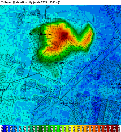
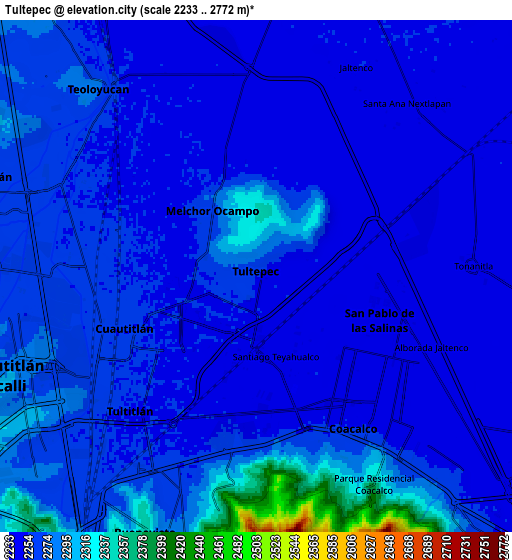
| \ | Map #1 | Map #2 | Topo.Map |
| Scale [m] | 2233..2353 m | 2233..2772 m | × |
| Scale [ft] | 7326..7720 ft | 7326..9094 ft | × |
| Average | 2255.2 m = 7399 ft | 2265.3 m = 7432 ft | × |
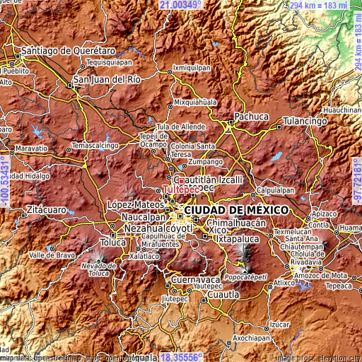
| Width | 9.2 km = 5.7 mi | 18.4 km = 11.4 mi | 294.4 km = 182.9 mi |
| Height | 9.2 km = 5.7 mi | 18.4 km = 11.4 mi | 294.4 km = 182.9 mi |
| ↑Max Latitude | 19.726372° | 19.767733° | 21.00349° |
| Latitude at center | 19.685° | 19.685° | 19.685° |
| ↓Min Latitude | 19.643618° | 19.602224° | 18.35556° |
| ← Min Longitude | -99.172005° | -99.215951° | -100.53431° |
| Longitude center | -99.12806° | -99.12806° | -99.12806° |
| →Max Longitude | -99.084115° | -99.040169° | -97.72181° |
Nearby cities:
Cities around Tultepec sort by population:
• San Pablo de las Salinas elevation 2248 m
4 km,  120°
120°
• Cuautitlán 2262 m
5.7 km,  253°
253°
• Fuentes del Valle 2256 m
5.9 km,  190°
190°
• Santiago Teyahualco 2249 m
2.8 km,  173°
173°
• Melchor Ocampo 2262 m
2.6 km,  316°
316°
• San Mateo Ixtacalco 2255 m
4.8 km,  289°
289°
• Colonia 2 de Septiembre 2309 m
2.1 km,  34°
34°
• San Francisco Tenopalco 2254 m
3.3 km,  22°
22°
• Lomas de Tenopalco 2299 m
2.5 km,  40°
40°
• San Antonio Xahuento 2247 m
2.3 km,  71°
71°
• Fracción San Roque (El Prieto) 2254 m
4.6 km,  273°
273°
• La Trinidad 2255 m
4.6 km,  263°
263°
Multilingual:
 En español:
Tultepec elevación 2257 m.
 En France:
Tultepec élévation 2257 m.
 Auf Deutsch:
Tultepec höhe über dem Meeresspiegel ist 2257 m.

Sources and notes:
- [note 1] Map square and city borders are not equal. Map elevation data is calculated only from area inside that square.
- [src 1] Elevation data from geonames database provided with same terms of usage.
- [src 2] The elevation map of Tultepec is generated using elevation data from NASA's 3 arcsec (90m) resolution SRTM data.
- [src 3] Base (background) map © OpenStreetMap contributors tiles are generated by Geofabrik and OpenTopoMap.
Copyright & License:
This Tultepec Elevation Map is licensed under CC BY-SA. You may reuse any part from this page, if you give a proper credit by linking to this URL:
 More info on terms of use page.