Túxpam de Rodríguez Cano elevation
Túxpam de Rodríguez Cano (Veracruz, Tuxpan), Mexico elevation is 11 meters and Túxpam de Rodríguez Cano elevation in feet is 36 ft above sea level [src 1]. Túxpam de Rodríguez Cano is a seat of a second-order administrative division (feature code) with elevation that is 1303 meters (4275 ft) smaller than average city elevation in Mexico.
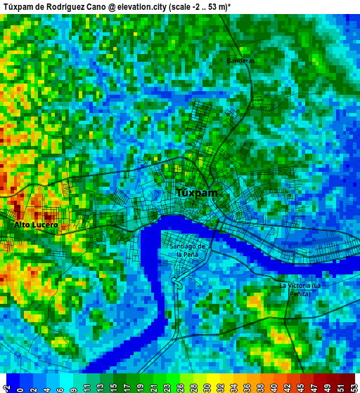
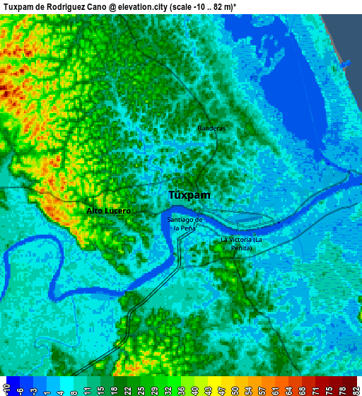
Below is the Elevation map of Túxpam de Rodríguez Cano, which displays elevation range with different colors. Scale of the first map is from -2 to 53 m (-7 to 174 ft) with average elevation of 12.8 meters (=42 ft) [note 1]
These maps also provides idea of topography and contour of this city, they are displayed at different zoom levels. More info about maps, scale and edge coordinates you can find below images.
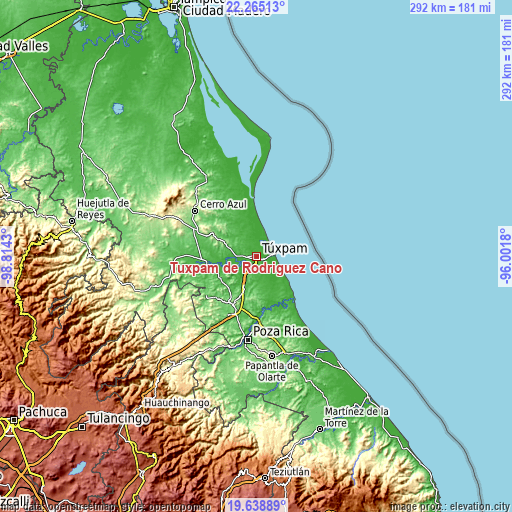
| \ | Map #1 | Map #2 | Topo.Map |
| Scale [m] | -2..53 m | -10..82 m | × |
| Scale [ft] | -7..174 ft | -33..269 ft | × |
| Average | 12.8 m = 42 ft | 14.3 m = 47 ft | × |
| Width | 9.13 km = 5.7 mi | 18.25 km = 11.3 mi | 292 km = 181.4 mi |
| Height | 9.13 km = 5.7 mi | 18.25 km = 11.3 mi | 292 km = 181.4 mi |
| ↑Max Latitude | 20.998802° | 21.039824° | 22.26513° |
| Latitude at center | 20.95777° | 20.95777° | 20.95777° |
| ↓Min Latitude | 20.916726° | 20.875671° | 19.63889° |
| ← Min Longitude | -97.451995° | -97.495941° | -98.8143° |
| Longitude center | -97.40805° | -97.40805° | -97.40805° |
| →Max Longitude | -97.364105° | -97.320159° | -96.0018° |
Nearby cities:
Cities around Túxpam de Rodríguez Cano sort by population:
• Alto Lucero elevation 37 m
3.5 km,  262°
262°
• Santiago de la Peña 8 m
1.4 km,  167°
167°
• Estero del Ídolo 26 m
27.1 km,  253°
253°
• Temapache 233 m
27.1 km,  296°
296°
• La Victoria (La Peñita) 4 m
4.4 km,  122°
122°
• Banderas 26 m
4 km,  22°
22°
• Hidalgo Amajac 18 m
23.7 km, 255°
• Doctor Montes de Oca 14 m
15.6 km, 260°
• Manlio Fabio Altamirano 12 m
25.1 km,  158°
158°
• Tierra Blanca 16 m
10.7 km,  210°
210°
• Ojite Rancho Nuevo 37 m
12.5 km,  275°
275°
• Buenos Aires (San Isidro) 60 m
24 km,  236°
236°
Multilingual:
 En español:
Túxpam, Túxpam de Rodríguez Cano elevación 11 m.
 En France:
Túxpam de Rodríguez Cano élévation 11 m.
 Auf Deutsch:
Túxpam de Rodríguez Cano höhe über dem Meeresspiegel ist 11 m.
 На русском:
Túxpam de Rodríguez Cano высота над уровнем моря 11 м
Sources and notes:
- [note 1] Map square and city borders are not equal. Map elevation data is calculated only from area inside that square.
- [src 1] Elevation data from geonames database provided with same terms of usage.
- [src 2] The elevation map of Túxpam de Rodríguez Cano is generated using elevation data from NASA's 3 arcsec (90m) resolution SRTM data.
- [src 3] Base (background) map © OpenStreetMap contributors tiles are generated by Geofabrik and OpenTopoMap.
Copyright & License:
This Túxpam de Rodríguez Cano Elevation Map is licensed under CC BY-SA. You may reuse any part from this page, if you give a proper credit by linking to this URL:
 More info on terms of use page.