Xalpatlahuac elevation
Xalpatlahuac (Guerrero, Xalpatláhuac), Mexico elevation is 1547 meters and Xalpatlahuac elevation in feet is 5075 ft above sea level [src 1]. Xalpatlahuac is a seat of a second-order administrative division (feature code) with elevation that is 233 meters (764 ft) bigger than average city elevation in Mexico.
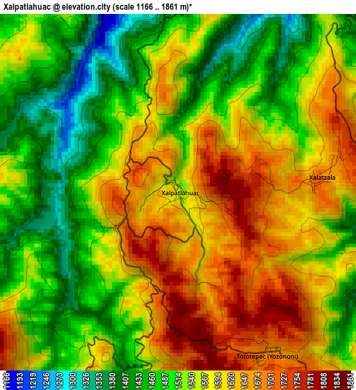
Below is the Elevation map of Xalpatlahuac, which displays elevation range with different colors. Scale of the first map is from 1166 to 1861 m (3825 to 6106 ft) with average elevation of 1553.4 meters (=5096 ft) [note 1]
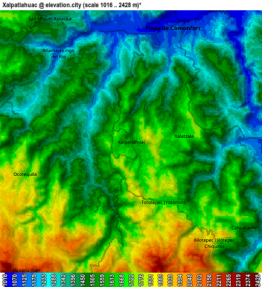
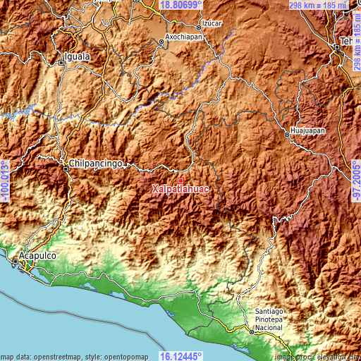
These maps also provides idea of topography and contour of this city, they are displayed at different zoom levels. More info about maps, scale and edge coordinates you can find below images.
| \ | Map #1 | Map #2 | Topo.Map |
| Scale [m] | 1166..1861 m | 1016..2428 m | × |
| Scale [ft] | 3825..6106 ft | 3333..7966 ft | × |
| Average | 1553.4 m = 5096 ft | 1542.7 m = 5061 ft | × |
| Width | 9.32 km = 5.8 mi | 18.64 km = 11.6 mi | 298.3 km = 185.4 mi |
| Height | 9.32 km = 5.8 mi | 18.64 km = 11.6 mi | 298.3 km = 185.4 mi |
| ↑Max Latitude | 17.512573° | 17.554477° | 18.80699° |
| Latitude at center | 17.47066° | 17.47066° | 17.47066° |
| ↓Min Latitude | 17.428737° | 17.386804° | 16.12445° |
| ← Min Longitude | -98.650695° | -98.694641° | -100.013° |
| Longitude center | -98.60675° | -98.60675° | -98.60675° |
| →Max Longitude | -98.562805° | -98.518859° | -97.2005° |
Nearby cities:
Cities around Xalpatlahuac sort by population:
• Tlapa de Comonfort elevation 1092 m
8.9 km,  21°
21°
• Copanatoyac 1377 m
11.4 km,  265°
265°
• Tototepec 1677 m
4.7 km,  154°
154°
• Xalatzala 1703 m
3.5 km,  84°
84°
• Atlamajac 1061 m
11.3 km,  33°
33°
• Cahuatache 1556 m
10 km,  127°
127°
• San Miguel Axoxuca 1383 m
10.5 km,  326°
326°
• Santa Anita 1571 m
12.9 km,  247°
247°
• Patlicha 1423 m
12.7 km, 254°
• Atlamajalcingo del Río 1150 m
8.1 km,  320°
320°
• Colonia Constitución 1208 m
7.4 km,  6°
6°
• Ocotequila 1706 m
7.9 km, 252°
Multilingual:
 En español:
Xalpatlahuac elevación 1547 m.
 En France:
Xalpatlahuac élévation 1547 m.
 Auf Deutsch:
Xalpatlahuac höhe über dem Meeresspiegel ist 1547 m.

Sources and notes:
- [note 1] Map square and city borders are not equal. Map elevation data is calculated only from area inside that square.
- [src 1] Elevation data from geonames database provided with same terms of usage.
- [src 2] The elevation map of Xalpatlahuac is generated using elevation data from NASA's 3 arcsec (90m) resolution SRTM data.
- [src 3] Base (background) map © OpenStreetMap contributors tiles are generated by Geofabrik and OpenTopoMap.
Copyright & License:
This Xalpatlahuac Elevation Map is licensed under CC BY-SA. You may reuse any part from this page, if you give a proper credit by linking to this URL:
 More info on terms of use page.