General Zaragoza elevation
General Zaragoza (Nuevo León), Mexico elevation is 1377 meters and General Zaragoza elevation in feet is 4518 ft above sea level [src 1]. General Zaragoza is a seat of a second-order administrative division (feature code) with elevation that is 63 meters (207 ft) bigger than average city elevation in Mexico.
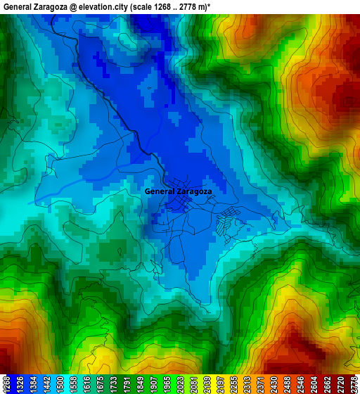
Below is the Elevation map of General Zaragoza, which displays elevation range with different colors. Scale of the first map is from 1268 to 2778 m (4160 to 9114 ft) with average elevation of 1762.2 meters (=5781 ft) [note 1]
These maps also provides idea of topography and contour of this city, they are displayed at different zoom levels. More info about maps, scale and edge coordinates you can find below images.
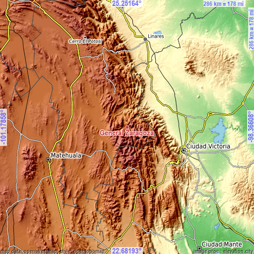
| \ | Map #1 | Topo.Map |
| Scale [m] | 1268..2778 m | × |
| Scale [ft] | 4160..9114 ft | × |
| Average | 1762.2 m = 5781 ft | × |
| Width | 8.93 km = 5.5 mi | 285.7 km = 177.5 mi |
| Height | 8.93 km = 5.5 mi | 285.7 km = 177.5 mi |
| ↑Max Latitude | 24.013338° | 25.25164° |
| Latitude at center | 23.97319° | 23.97319° |
| ↓Min Latitude | 23.933029° | 22.68193° |
| ← Min Longitude | -99.816275° | -101.17858° |
| Longitude center | -99.77233° | -99.77233° |
| →Max Longitude | -99.728385° | -98.36608° |
Nearby cities:
Cities around General Zaragoza sort by population:
• Doctor Arroyo elevation 1716 m
53.4 km,  231°
231°
• Guillermo Zúñiga 221 m
58.3 km,  85°
85°
• Estación Santa Engracia 219 m
58.1 km, 85°
• Hidalgo 331 m
45.6 km,  47°
47°
• Barretal 201 m
66.8 km,  79°
79°
• La Ascensión 1961 m
41.6 km,  339°
339°
• Aramberri 1086 m
14.8 km, 342°
• Miquihuana 1863 m
44.2 km,  177°
177°
• Bustamante 1694 m
59.8 km, 178°
• La Libertad 319 m
62.5 km,  108°
108°
• Villagrán 385 m
62.4 km,  27°
27°
• La Misión 287 m
64.1 km, 107°
Multilingual:
 En español:
General Zaragoza elevación 1377 m.
 En France:
General Zaragoza élévation 1377 m.
 Auf Deutsch:
General Zaragoza höhe über dem Meeresspiegel ist 1377 m.

Sources and notes:
- [note 1] Map square and city borders are not equal. Map elevation data is calculated only from area inside that square.
- [src 1] Elevation data from geonames database provided with same terms of usage.
- [src 2] The elevation map of General Zaragoza is generated using elevation data from NASA's 3 arcsec (90m) resolution SRTM data.
- [src 3] Base (background) map © OpenStreetMap contributors tiles are generated by Geofabrik and OpenTopoMap.
Copyright & License:
This General Zaragoza Elevation Map is licensed under CC BY-SA. You may reuse any part from this page, if you give a proper credit by linking to this URL:
 More info on terms of use page.