Zinacantán elevation
Zinacantán (Chiapas), Mexico elevation is 2160 meters and Zinacantán elevation in feet is 7087 ft above sea level [src 1]. Zinacantán is a seat of a second-order administrative division (feature code) with elevation that is 846 meters (2776 ft) bigger than average city elevation in Mexico.
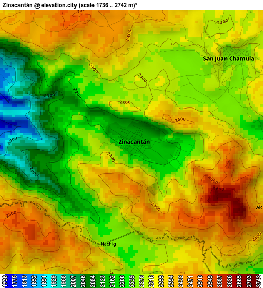
Below is the Elevation map of Zinacantán, which displays elevation range with different colors. Scale of the first map is from 1736 to 2742 m (5696 to 8996 ft) with average elevation of 2301.1 meters (=7550 ft) [note 1]
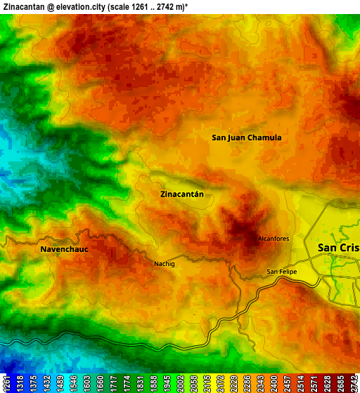
These maps also provides idea of topography and contour of this city, they are displayed at different zoom levels. More info about maps, scale and edge coordinates you can find below images.
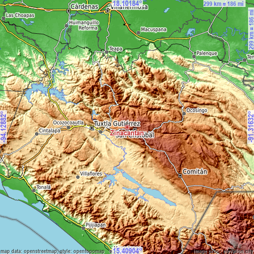
| \ | Map #1 | Map #2 | Topo.Map |
| Scale [m] | 1736..2742 m | 1261..2742 m | × |
| Scale [ft] | 5696..8996 ft | 4137..8996 ft | × |
| Average | 2301.1 m = 7550 ft | 2199.9 m = 7218 ft | × |
| Width | 9.36 km = 5.8 mi | 18.71 km = 11.6 mi | 299.4 km = 186 mi |
| Height | 9.36 km = 5.8 mi | 18.71 km = 11.6 mi | 299.4 km = 186 mi |
| ↑Max Latitude | 16.802274° | 16.844338° | 18.10184° |
| Latitude at center | 16.7602° | 16.7602° | 16.7602° |
| ↓Min Latitude | 16.718117° | 16.676024° | 15.40904° |
| ← Min Longitude | -92.766515° | -92.810461° | -94.12882° |
| Longitude center | -92.72257° | -92.72257° | -92.72257° |
| →Max Longitude | -92.678625° | -92.634679° | -91.31632° |
Nearby cities:
Cities around Zinacantán sort by population:
• San Cristóbal de las Casas elevation 2125 m
9.2 km,  110°
110°
• Navenchauc 2254 m
6.6 km,  245°
245°
• Pasté 2314 m
6.5 km,  197°
197°
• Chamula 2289 m
4.4 km,  52°
52°
• Nachig 2270 m
3.3 km,  185°
185°
• San Antonio del Monte 2243 m
7.4 km,  89°
89°
• Patosil 2313 m
2.2 km, 245°
• Catishtic 2247 m
2.8 km,  324°
324°
• Cuchulumtic 2257 m
2.7 km, 45°
• Bautista Chico 2398 m
4.5 km,  14°
14°
• Arvenza Uno 2314 m
2.2 km, 6°
• Bochojbo Alto 2442 m
2.8 km,  167°
167°
Multilingual:
 En español:
Zinacantán elevación 2160 m.
 En France:
Zinacantán élévation 2160 m.
 Auf Deutsch:
Zinacantán höhe über dem Meeresspiegel ist 2160 m.

Sources and notes:
- [note 1] Map square and city borders are not equal. Map elevation data is calculated only from area inside that square.
- [src 1] Elevation data from geonames database provided with same terms of usage.
- [src 2] The elevation map of Zinacantán is generated using elevation data from NASA's 3 arcsec (90m) resolution SRTM data.
- [src 3] Base (background) map © OpenStreetMap contributors tiles are generated by Geofabrik and OpenTopoMap.
Copyright & License:
This Zinacantán Elevation Map is licensed under CC BY-SA. You may reuse any part from this page, if you give a proper credit by linking to this URL:
 More info on terms of use page.