Zongozotla elevation
Zongozotla (Puebla), Mexico elevation is 1129 meters and Zongozotla elevation in feet is 3704 ft above sea level [src 1]. Zongozotla is a seat of a second-order administrative division (feature code) with elevation that is 185 meters (607 ft) smaller than average city elevation in Mexico.
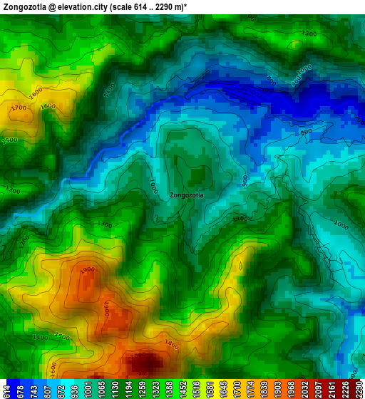
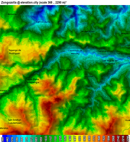
Below is the Elevation map of Zongozotla, which displays elevation range with different colors. Scale of the first map is from 614 to 2290 m (2014 to 7513 ft) with average elevation of 1203.2 meters (=3948 ft) [note 1]
These maps also provides idea of topography and contour of this city, they are displayed at different zoom levels. More info about maps, scale and edge coordinates you can find below images.
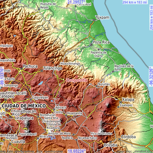
| \ | Map #1 | Map #2 | Topo.Map |
| Scale [m] | 614..2290 m | 368..2290 m | × |
| Scale [ft] | 2014..7513 ft | 1207..7513 ft | × |
| Average | 1203.2 m = 3948 ft | 1210.1 m = 3970 ft | × |
| Width | 9.18 km = 5.7 mi | 18.37 km = 11.4 mi | 293.9 km = 182.6 mi |
| Height | 9.18 km = 5.7 mi | 18.37 km = 11.4 mi | 293.9 km = 182.6 mi |
| ↑Max Latitude | 20.020595° | 20.061879° | 21.29527° |
| Latitude at center | 19.9793° | 19.9793° | 19.9793° |
| ↓Min Latitude | 19.937994° | 19.896677° | 18.65224° |
| ← Min Longitude | -97.771455° | -97.815401° | -99.13376° |
| Longitude center | -97.72751° | -97.72751° | -97.72751° |
| →Max Longitude | -97.683565° | -97.639619° | -96.32126° |
Nearby cities:
Cities around Zongozotla sort by population:
• Huitzilan elevation 922 m
3.7 km,  110°
110°
• Tepango 1531 m
7.7 km,  290°
290°
• Ixtepec 1059 m
9.9 km,  59°
59°
• Tuxtla 908 m
7.9 km,  72°
72°
• San Miguel del Progreso 900 m
6.5 km,  79°
79°
• Hueytlalpan 943 m
6.2 km,  31°
31°
• Tlamanca de Hernández 1413 m
9.5 km,  254°
254°
• Zapotitlán 667 m
2.9 km, 29°
• Camocuautla 716 m
7.3 km,  333°
333°
• Nanacatlán 926 m
6 km, 63°
• Chipahuatlán 942 m
10 km,  24°
24°
• Zoyotla 1149 m
6.7 km,  148°
148°
Multilingual:
 En español:
Zongozotla elevación 1129 m.
 En France:
Zongozotla élévation 1129 m.
 Auf Deutsch:
Zongozotla höhe über dem Meeresspiegel ist 1129 m.

Sources and notes:
- [note 1] Map square and city borders are not equal. Map elevation data is calculated only from area inside that square.
- [src 1] Elevation data from geonames database provided with same terms of usage.
- [src 2] The elevation map of Zongozotla is generated using elevation data from NASA's 3 arcsec (90m) resolution SRTM data.
- [src 3] Base (background) map © OpenStreetMap contributors tiles are generated by Geofabrik and OpenTopoMap.
Copyright & License:
This Zongozotla Elevation Map is licensed under CC BY-SA. You may reuse any part from this page, if you give a proper credit by linking to this URL:
 More info on terms of use page.